| Agua Caliente (AGUC1) | 0.00 |
| Alpine (ANEC1) | 0.56 |
| Barona (BNAC1) | 0.13 |
| Barret Lake (BRTC1) | 0.39 |
| Barrett Junction (BAJC1) | 0.49 |
| Birch Hill (IRCC1) | 0.58 |
| Bonita (BNNC1) | 0.11 |
| Bonsall (BOSC1) | 0.44 |
| Borrego Palm Canyon (BRPC1) | 0.00 |
| Borrego Springs (BGOC1) | 0.01 |
| Brown Field (SDM) | 0.43 |
| Cactus County Park (CCPC1) | 0.02 |
| Cameron Guard Station (CMNC1) | 0.32 |
| Camp Elliot (MPEC1) | 0.10 |
| Campo (CMFC1) | 0.13 |
| Case Springs (CSPC1) | 0.03 |
| CMP Target Range (CTGC1) | 0.03 |
| Core Grade Road (OLEC1) | 0.39 |
| Couser Canyon (OUSC1) | 0.43 |
| Coyote Cyn Creek (CCYC1) | 0.00 |
| Cuyamaca Reservoir (CYDC1) | 0.56 |
| Deer Springs (DRGC1) | 0.45 |
| Descanso (DENC1) | 0.53 |
| Descanso RS (DSCC1) | 0.59 |
| Dulzura Summit (DULC1) | 0.25 |
| Eastern Tanks (ETKC1) | 0.48 |
| Echo Dell (ECDC1) | 0.52 |
| El Cajon (LCKC1) | 0.12 |
| El Camino Del Norte (ECMC1) | 0.15 |
| El Capitan Dam (ELPC1) | 0.08 |
| Encinitas (ENCC1) | 0.12 |
| Escondido (ESOC1) | 0.24 |
| Fallbrook 5NE (FBOC1) | 0.16 |
| Fallbrook (FBZC1) | 0.07 |
| Fallbrook (FLBC1) | 0.18 |
| Fallbrook Community AP (L18) | 0.10 |
| Fashion Valley (FSNC1) | 0.11 |
| Flinn Springs (FLYC1) | 0.08 |
| Goose Valley (GOSC1) | 0.08 |
| Granite Hills (GRHC1) | 0.12 |
| Harbison Canyon (HARC1) | 0.29 |
| Henshaw Dam (HAWC1) | 0.22 |
| Japatul Fire Station (JFSC1) | 0.51 |
| Julian (JLNC1) | 0.16 |
| Julian (JULC1) | 0.17 |
| Kearny Mesa (KEAC1) | 0.09 |
| La Jolla Amago (LJOC1) | 0.18 |
| La Mesa (LMSC1) | 0.17 |
| Lake Hodges (HODC1) | 0.20 |
| Lake Morena (MRAC1) | 0.35 |
| Lake Murray (MUYC1) | 0.16 |
| Las Flores (LSFC1) | 0.06 |
| Lindbergh Int'l Airport (SAN) | 0.13 |
| Loma Tova (LMTB1) | 0.00 |
| Lower Oat Flats (OFLC1) | 0.39 |
| Marron Valley (MAVC1) | 0.32 |
| Mesa Grande (MEGC1) | 0.14 |
| Miramar Lake (MMRC1) | 0.18 |
| Mission Valley (BVDC1) | 0.11 |
| Missle (MSXC1) | 0.08 |
| Montgomery Field (MYF) | 0.10 |
| Mount Laguna (LGMC1) | 0.17 |
| Mount Laguna (MLGC1) | 0.17 |
| Mt Woodson Rd - Ramona (RMAC1) | 0.11 |
| Oak Grove (OGVC1) | 0.26 |
| Oceanside (OCNC1) | 0.27 |
| Oceanside (OKB) | 0.24 |
| Otay Mountain (OTYC1) | 0.61 |
| Pala 2W (PZAC1) | 0.18 |
| Palomar Airport (CRQ) | 0.40 |
| Palomar Airport (PLMC1) | 0.43 |
| Palomar Mountain (PRMC1) | 0.37 |
| Palomar Mountain CRS (PMMC1) | 0.77 |
| Palomar Mountain USFS (PAMC1) | 0.38 |
| Pine Hills (PIHC1) | 0.39 |
| Pine Hills Fire Station (PHIC1) | 0.43 |
| Pine Valley County Park (PNVC1) | 0.32 |
| Point Loma (L13) | 0.13 |
| Potrero (PRCC1) | 0.24 |
| Potrero CDF (POTC1) | 0.22 |
| Poway (PWYC1) | 0.23 |
| Rainbow Camp (RAIC1) | 0.22 |
| Rainbow County Park (RABC1) | 0.23 |
| Ramona (RMNC1) | 0.03 |
| Ranchita (RTAC1) | 0.08 |
| Ranchita CDF (RCHC1) | 0.07 |
| Ranchita Margarita (RMGC1) | 0.35 |
| Rancho Bernardo (RNBC1) | 0.07 |
| Red Gate Repeater (RGPC1) | 0.35 |
| Rincon Springs (RINC1) | 0.27 |
| Roads Division 1 HQ (RDHC1) | 0.28 |
| San Diego Estates (ESTC1) | 0.08 |
| San Felipe Valley (SFVC1) | 0.00 |
| San Marcos Cnty Rd Station (SMXC1) | 0.45 |
| San Marcos Landfill (NMLC1) | 0.30 |
| San Miguel (MIGC1) | 0.33 |
| San Pasqual (PSQC1) | 0.09 |
| San Ysidro (YSDC1) | 0.31 |
| Santa Rosa Plateau (SRUC1) | 0.07 |
| Santa Ysabel (SYSC1) | 0.14 |
| Santee - Mast Rd (STEC1) | 0.07 |
| Skyline Ranch (SKLC1) | 0.16 |
| Smugglers Gulch (UGGC1) | 0.12 |
| Sutherland Dam (SUDC1) | 0.09 |
| Talega (TLGC1) | 0.06 |
| Temecula (TEMC1) | 0.20 |
| Thousand Trails - Jamul (TTRC1) | 0.43 |
| Tierra Del Sol (TRRC1) | 0.05 |
| Tijuana Estuary (TJEC1) | 0.16 |
| Tijuana R - Int'l Boundary (TIJC1) | 0.00 |
| Valley Center (VALC1) | 0.22 |
| Valley Center (VLCC1) | 0.29 |
| Volcano Mountain (VCNC1) | 0.10 |
| Warner Springs (WSGC1) | 0.11 |
| Wire Mountain (WIRC1) | 0.17 |
| Witch Creek Fire Station (WCHC1) | 0.08 |
| Wohlford Dam (WHLC1) | 0.25 |
ADVERTISEMENT
SAN DIEGO RAIN TOTALS: MONDAY 1-17-2022
SAN DIEGO RAIN TOTALS: SATURDAY 1-15-2022
| Agua Caliente (AGUC1) | 0.00 |
| Alpine (ANEC1) | 0.00 |
| Barona (BNAC1) | 0.00 |
| Barret Lake (BRTC1) | 0.01 |
| Barrett Junction (BAJC1) | 0.05 |
| Birch Hill (IRCC1) | 0.06 |
| Bonita (BNNC1) | 0.02 |
| Bonsall (BOSC1) | 0.00 |
| Borrego Palm Canyon (BRPC1) | 0.00 |
| Borrego Springs (BGOC1) | 0.00 |
| Brown Field (SDM) | 0.04 |
| Cactus County Park (CCPC1) | 0.03 |
| Cameron Guard Station (CMNC1) | 0.01 |
| Camp Elliot (MPEC1) | 0.02 |
| Campo (CMFC1) | 0.00 |
| Case Springs (CSPC1) | 0.02 |
| CMP Target Range (CTGC1) | 0.03 |
| Core Grade Road (OLEC1) | 0.00 |
| Couser Canyon (OUSC1) | 0.00 |
| Coyote Cyn Creek (CCYC1) | 0.00 |
| Cuyamaca Reservoir (CYDC1) | 0.01 |
| Deer Springs (DRGC1) | 0.00 |
| Descanso (DENC1) | 0.02 |
| Descanso RS (DSCC1) | 0.02 |
| Dulzura Summit (DULC1) | 0.07 |
| Eastern Tanks (ETKC1) | 0.00 |
| Echo Dell (ECDC1) | 0.01 |
| El Cajon (LCKC1) | 0.04 |
| El Camino Del Norte (ECMC1) | 0.02 |
| El Capitan Dam (ELPC1) | 0.03 |
| Encinitas (ENCC1) | 0.03 |
| Escondido (ESOC1) | 0.02 |
| Fallbrook 5NE (FBOC1) | 0.00 |
| Fallbrook (FBZC1) | 0.00 |
| Fallbrook (FLBC1) | 0.00 |
| Fallbrook Community AP (L18) | 0.00 |
| Fashion Valley (FSNC1) | 0.03 |
| Flinn Springs (FLYC1) | 0.05 |
| Goat Canyon (GOCC1) | 0.04 |
| Goose Valley (GOSC1) | 0.00 |
| Granite Hills (GRHC1) | 0.04 |
| Harbison Canyon (HARC1) | 0.02 |
| Henshaw Dam (HAWC1) | 0.00 |
| Japatul Fire Station (JFSC1) | 0.07 |
| Julian (JLNC1) | 0.01 |
| Julian (JULC1) | 0.01 |
| Kearny Mesa (KEAC1) | 0.04 |
| La Jolla Amago (LJOC1) | 0.00 |
| La Mesa (LMSC1) | 0.02 |
| Lake Hodges (HODC1) | 0.03 |
| Lake Morena (MRAC1) | 0.01 |
| Lake Murray (MUYC1) | 0.00 |
| Las Flores (LSFC1) | 0.03 |
| Lindbergh Int'l Airport (SAN) | 0.03 |
| Loma Tova (LMTB1) | 0.00 |
| Lower Oat Flats (OFLC1) | 0.00 |
| Marron Valley (MAVC1) | 0.08 |
| Mesa Grande (MEGC1) | 0.05 |
| Miramar Lake (MMRC1) | 0.03 |
| Mission Valley (BVDC1) | 0.03 |
| Missle (MSXC1) | 0.02 |
| Montgomery Field (MYF) | 0.04 |
| Mount Laguna (LGMC1) | 0.00 |
| Mount Laguna (MLGC1) | 0.00 |
| Mt Woodson Rd - Ramona (RMAC1) | 0.04 |
| North Island NAS (NZY) | 0.02 |
| Oak Grove (OGVC1) | 0.00 |
| Oceanside (OCNC1) | 0.05 |
| Oceanside (OKB) | 0.05 |
| Otay Mountain (OTYC1) | 0.15 |
| Pala 2W (PZAC1) | 0.00 |
| Palomar Airport (CRQ) | 0.04 |
| Palomar Airport (PLMC1) | 0.03 |
| Palomar Mountain (PRMC1) | 0.03 |
| Palomar Mountain CRS (PMMC1) | 0.04 |
| Palomar Mountain USFS (PAMC1) | 0.05 |
| Pine Hills (PIHC1) | 0.02 |
| Pine Hills Fire Station (PHIC1) | 0.01 |
| Pine Valley County Park (PNVC1) | 0.02 |
| Point Loma (L13) | 0.05 |
| Potrero (PRCC1) | 0.04 |
| Potrero CDF (POTC1) | 0.03 |
| Poway (PWYC1) | 0.02 |
| Rainbow Camp (RAIC1) | 0.00 |
| Rainbow County Park (RABC1) | 0.01 |
| Ramona (RMNC1) | 0.00 |
| Ranchita (RTAC1) | 0.00 |
| Ranchita CDF (RCHC1) | 0.00 |
| Ranchita Margarita (RMGC1) | 0.01 |
| Rancho Bernardo (RNBC1) | 0.02 |
| Red Gate Repeater (RGPC1) | 0.00 |
| Rincon Springs (RINC1) | 0.00 |
| Roads Division 1 HQ (RDHC1) | 0.03 |
| San Diego Estates (ESTC1) | 0.00 |
| San Felipe Valley (SFVC1) | 0.00 |
| San Marcos Cnty Rd Station (SMXC1) | 0.04 |
| San Marcos Landfill (NMLC1) | 0.03 |
| San Miguel (MIGC1) | 0.04 |
| San Pasqual (PSQC1) | 0.01 |
| San Ysidro (YSDC1) | 0.00 |
| Santa Rosa Plateau (SRUC1) | 0.00 |
| Santa Ysabel (SYSC1) | 0.00 |
| Santee - Mast Rd (STEC1) | 0.03 |
| Skyline Ranch (SKLC1) | 0.00 |
| Smugglers Gulch (UGGC1) | 0.04 |
| Sutherland Dam (SUDC1) | 0.01 |
| Talega (TLGC1) | 0.03 |
| Temecula (TEMC1) | 0.00 |
| Thousand Trails - Jamul (TTRC1) | 0.06 |
| Tierra Del Sol (TRRC1) | 0.03 |
| Tijuana Estuary (TJEC1) | 0.04 |
| Tijuana R - Int'l Boundary (TIJC1) | 0.02 |
| Valley Center (VALC1) | 0.00 |
| Valley Center (VLCC1) | 0.00 |
| Volcano Mountain (VCNC1) | 0.00 |
| Warner Springs (WSGC1) | 0.00 |
| Wire Mountain (WIRC1) | 0.04 |
| Witch Creek Fire Station (WCHC1) | 0.01 |
| Wohlford Dam (WHLC1) | 0.00 |
WEATHER UPDATE: SATURDAY 1-15-2022
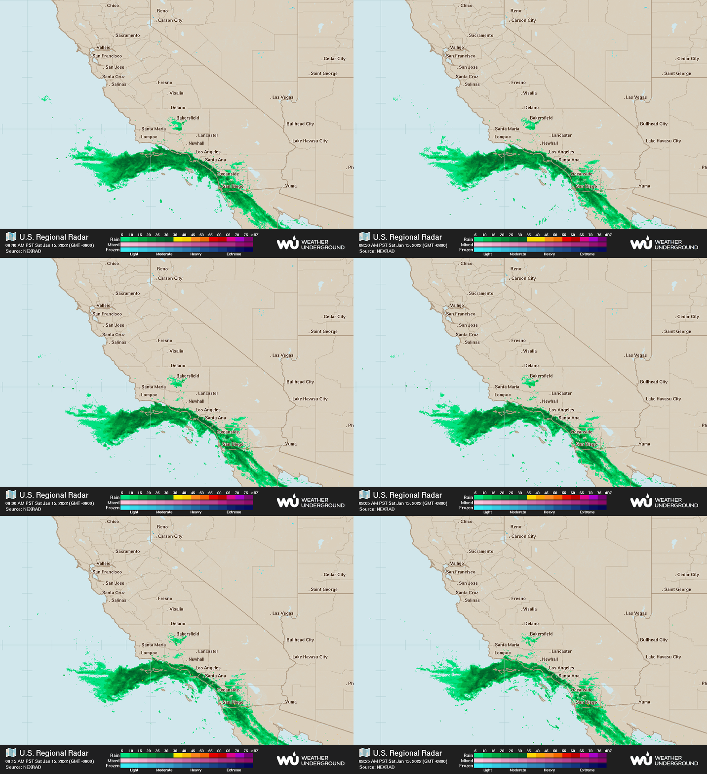
A band of showers is currently moving across San Diego County - seen on the radar loop below. This band of showers will dissipate from noon to 2 PM, so most areas should be completely dry by late afternoon.
This pesky storm system has been parked out in the Pacific for the past few days. It is cut off from the guiding winds in the upper atmosphere, so it's difficult to forecast. However, it looks like it will finally migrate overhead Monday and Tuesday.
There isn't mush moisture associated with system, so rain chances are low. Regardless, an isolated shower could pop up at any time Monday or Tuesday. Snow levels will be high, so no snow is expected in local mountains.
Long range forecast still generally looks dry, though an occasional shower could pop up from time to time. There are hints of a slight pattern change by the end of the month. Hopefully this could eventually bring a more substantial rain by early February. As always, I'll keep an eye on it in the coming days.
 |
| Radar loop at 9:45 AM Saturday 1-15-2022 |
WEATHER UPDATE: SUNDAY 1-9-2022
Unfortunately Monday's rain chance has evaporated. Most of the energy is going to split to the north and south around our area. The computer's are having a difficult time with this transition in the weather pattern.
Luckily, the December rains put coastal and inland areas of Southern California in a surplus for this rain season. Things are drastically different further inland to the desert regions of Southeast California, where it's very dry compared to normal. I've included an updated map of the entire state, which also shows that a lot of areas are doing good for rainfall...for now.
We are still in a La Nina, where equatorial water temperatures in the Pacific are cool. This usually equates to generally dry conditions for our area.
Looking at the long term computer projection for the next ten days (third map), it's looking pretty dry across the entire state of California. We might see a renegade storm sneak in during this time period, but otherwise, it's looking very dry.
Looking even farther out, I don't see much change to this pattern through January. I'll keep watching and bring updates if there are any changes.
 |
| Percent of rainfall so far this rain season. |
 |
| A moderate La Nina can be seen along the equator off the west coast of South America. |
 |
| Computer projection for total rainfall for the next ten days. |
NEXT RAIN CHANCE SAN DIEGO: UPDATED FRIDAY 1-7-2021
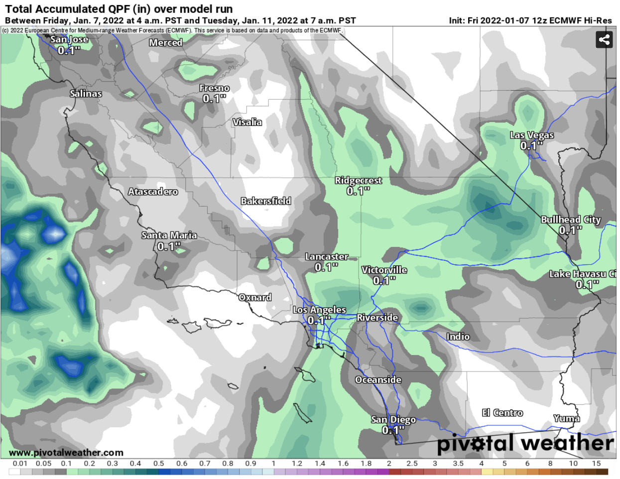
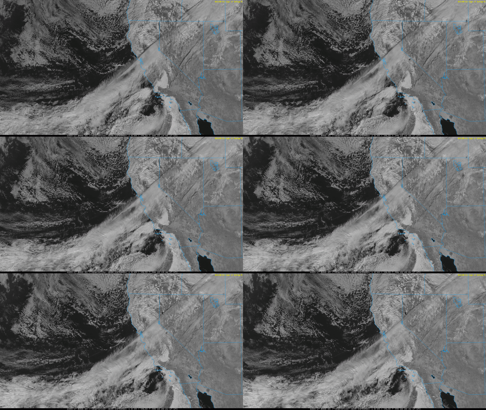
A weak front will pass the area tonight and bring a chance for a few light showers (you can see the clouds approaching on the satellite loop below). The best chance for a light shower will be from 9 PM to 7 AM tonight and rain totals will be 0.1" or less. Snow levels will remain high, so no snow is expected in local mountains.
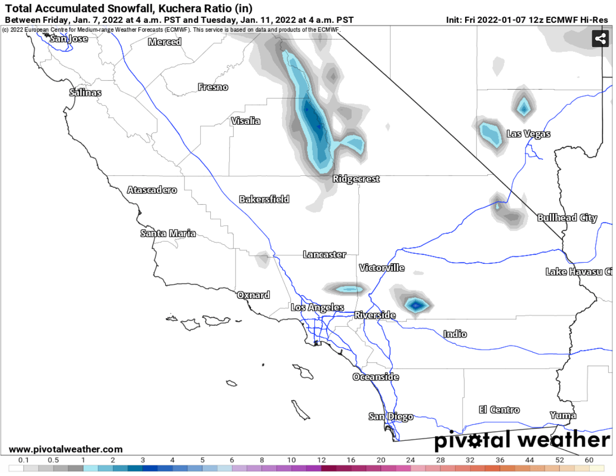
Another weak system will pass the area on Monday and bring another chance for a few showers. Snow levels will again remain high, though there should be accumulations in the San Jacinto and San Bernardino mountains.
I've attached the computer projected rain and snow totals on the maps below.
The long term weather pattern is still generally dry for at the least next couple weeks, though an occasional shower could pop up from time to time. I'll bring more updates if I see a bigger pattern change, but for now it isn't looking to great for substantial rainfall.
 |
| Computer projected rainfall through 7 AM next Tuesday. |
 |
| Computer projected snowfall through 7 AM next Tuesday. |
SAN DIEGO 2021 RECAP: RAINFALL AND TEMPERATURES
2021 was a dry and slightly warmer than normal year. April and July were both warm months, while October and December were much cooler than normal. Almost every month had below average rainfall with October and December being notable exceptions.
I've posted data for San Diego County, California and the entire United States below.
| Average Temperature | Departure From Normal | Total Rainfall | Departure From Normal | |
| Jan | 58.0 | 0.9 | 1.80 | -0.18 |
| Feb | 59.0 | 1.1 | 0.10 | -2.17 |
| Mar | 58.9 | -0.5 | 1.48 | -0.33 |
| Apr | 63.8 | 2.0 | 0.07 | -0.71 |
| May | 64.8 | 0.0 | 0.07 | -0.21 |
| Jun | 68.2 | 1.0 | 0.01 | -0.04 |
| Jul | 73.1 | 2.4 | 0.00 | -0.08 |
| Aug | 73.6 | 1.2 | 0.23 | 0.22 |
| Sep | 72.5 | 0.8 | 0.50 | 0.38 |
| Oct | 66.8 | -1.3 | 1.01 | 0.51 |
| Nov | 64.3 | 1.5 | 0.00 | -0.79 |
| Dec | 55.6 | -2.3 | 2.58 | 0.91 |
| Total | 64.9 | 0.6 | 7.85 | -2.49 |
Here are the rain totals by month (click to enlarge). You can see that most of the rain came in January, March, October and December.
Here is a graph that plots temperatures through the year. The light gray shaded area represents normal temperatures. Generally, we stayed within the norm, though you can see some periods of warmth in January, February, July and November. Conversely, October and December had days that were cooler than normal.
Here are the rain totals across California.
This map shows the percentage from normal for rainfall across California. This helps to highlight which areas were extraordinarily wet or dry. Most of the state was below normal, though the southern third of the state was the worst. There were some pockets of higher rainfall in Central California, especially into parts of the Sierra Nevada. Most of this rain came in December, otherwise, these areas were also dry.
This map shows the ranking for rainfall, which shows that no records were broken. If we didn't receive all that rain in December, this map would look dramatically different.
This map shows the temperature departure from normal across California. Although coastal San Diego County saw near normal temperatures, most of the state was significantly warmer than normal.
Here are the temperature rankings, which shows several areas across the state with record breaking heat.
This map shows the rainfall across the United States in 2021.
This shows the departure from normal rainfall in the United States. Most of the Western states were dry, while the Gulf Coast saw large amounts of rainfall due to an active hurricane season.
This map shows the percentage of normal rainfall. Some of the rain totals in the Southeast were record breaking.
Here is a map of temperature departures from normal across the country. Generally, most areas were above average for the year.
Here are the temperature rankings, which shows that some areas in the Southwest and Northeast United States saw record breaking heat.
Lastly, here are the monthly rain totals across San Diego County for 2021.
DECEMBER 2021 SAN DIEGO RAIN TOTALS
Coastal and inland rain totals were 2 to 4", mountain totals ranged from 4 to 10". This was 150 to 250% of the normal values for December. I've posted all the data below.
| BARONA (BNAC1) | 4.29 |
| BARRET LAKE (BRTC1) | 5.34 |
| BONSALL (BOSC1) | 4.18 |
| BROWN FIELD - SAN DIEGO CO (SDM) | 3.39 |
| CACTUS COUNTY PARK (CCPC1) | 3.54 |
| CAMP PENDELTON (NFG) | 3.50 |
| COLE GRADE ROAD (OLEC1) | 4.31 |
| DESCANSO (USFS) (DENC1) | 6.68 |
| ENCINITAS (ENCC1) | 2.83 |
| ESCONDIDO (ESOC1) | 4.56 |
| GOOSE VALLEY (USFS) (GOSC1) | 4.56 |
| GRANITE HILLS (GRHC1) | 3.84 |
| JULIAN (JULC1) | 9.74 |
| KEARNY MESA (KEAC1) | 3.39 |
| LA MESA (LMSC1) | 3.86 |
| OCEANSIDE (OCNC1) | 4.06 |
| PALOMAR AIRPORT (PLMC1) | 3.25 |
| PINE HILLS (USFS) (PIHC1) | 9.11 |
| POTRERO (CDF) (POTC1) | 4.98 |
| POWAY (PWYC1) | 3.29 |
| RAMONA (RMNC1) | 4.76 |
| SAN DIEGO - FASHION VLY (FSNC1) | 3.60 |
| SAN DIEGO - LINDBERGH - ASOS (SAN) | 2.73 |
| SAN DIEGO - MAST ROAD, AT, SANTEE, NR (STEC1) | 3.71 |
| SAN DIEGO-EL CAPITAN DAM (ELPC1) | 4.90 |
| SANTA YSABEL (SYSC1) | 6.76 |
| SUTHERLAND DAM (SUDC1) | 5.57 |
| THOUSAND TRAILS NR JAMUL (TTRC1) | 4.79 |
| VALLECITOS REPEATER (VCIC1) | 8.55 |
| VALLEY CENTER (CDF) (VLCC1) | 5.00 |
FORECAST
BLOG ARCHIVE
- ► 2015 (118)


