ADVERTISEMENT

SAN DIEGO RAIN TOTALS: TUESDAY 12-27-2022 TO WEDNESDAY 12-28-2022

Agua Caliente (AGUC1)0.01
Barona (BNAC1)0.69
Barret Lake (BRTC1)0.55
Birch Hill (IRCC1)1.08
Bonita (BNNC1)0.71
Bonsall (BOSC1)0.70
Borrego Palm Canyon (BRPC1)0.06
Borrego Springs (BGOC1)0.01
Brown Field (SDM)0.59
Cactus County Park (CCPC1)0.84
Camp Elliot (MPEC1)0.73
Camp Pendleton (PPDC1)0.71
Campo (CMFC1)0.49
Case Springs (CSPC1)0.52
CMP Target Range (CTGC1)0.67
Core Grade Road (OLEC1)0.63
Couser Canyon (OUSC1)0.65
Coyote Cyn Creek (CCYC1)0.03
Cuyamaca Reservoir (CYDC1)1.03
Deer Springs (DRGC1)0.75
Descanso RS (DSCC1)0.89
Dulzura Summit (DULC1)0.00
Eastern Tanks (ETKC1)0.91
Echo Dell (ECDC1)1.01
El Camino Del Norte (ECMC1)0.75
El Capitan Dam (ELPC1)1.20
Encinitas (ENCC1)0.77
Escondido (ESOC1)0.81
Fallbrook 5NE (FBOC1)0.47
Fallbrook (FBZC1)0.61
Fallbrook Community AP (L18)0.52
Fashion Valley (FSNC1)0.68
Flinn Springs (FLYC1)0.81
Granite Hills (GRHC1)0.70
Harbison Canyon (HARC1)0.87
Henshaw Dam (HAWC1)0.82
Julian (JLNC1)0.89
Kearny Mesa (KEAC1)0.61
La Jolla Amago (LJOC1)0.95
La Mesa (LMSC1)0.77
Lake Hodges (HODC1)0.65
Lake Morena (MRAC1)0.95
Lakeside / El Cajon (LCKC1)0.69
Las Flores (LSFC1)0.64
Lindbergh Int'l Airport (SAN)0.62
Loma Tova (LMTB1)0.00
Lower Oat Flats (OFLC1)0.72
Marron Valley (MAVC1)0.63
Mesa Grande (MEGC1)0.01
Miramar Lake (MMRC1)0.75
Miramar Marine Corps Station (NKX)0.65
Mount Laguna (LGMC1)0.60
Mt Woodson Rd - Ramona (RMAC1)0.86
Oak Grove (OGVC1)0.56
Oceanside (OCNC1)0.62
Oceanside (OKB)0.62
Otay Mountain (OTYC1)0.84
Palomar Airport (PLMC1)0.75
Palomar Mountain (PRMC1)0.81
Palomar Mountain CRS (PMMC1)1.20
Palomar Mountain USFS (PAMC1)0.96
Pine Hills Fire Station (PHIC1)1.04
Pine Valley County Park (PNVC1)0.69
Point Loma (L13)0.65
Potrero (PRCC1)0.84
Potrero CDF (POTC1)0.83
Poway (PWYC1)0.62
Rainbow Camp (RAIC1)0.62
Rainbow County Park (RABC1)0.53
Ramona (RMNC1)0.79
Ramona (RNM)0.61
Ranchita (RTAC1)0.48
Ranchita CDF (RCHC1)0.36
Ranchita Margarita (RMGC1)1.10
Rancho Bernardo (RNBC1)0.65
Red Gate Repeater (RGPC1)0.71
Rincon Springs (RINC1)0.63
Roads Division 1 HQ (RDHC1)0.74
San Diego Estates (ESTC1)0.75
San Felipe Valley (SFVC1)0.12
San Marcos Cnty Rd Station (SMXC1)0.72
San Marcos Landfill (NMLC1)0.63
Santa Ysabel (SYSC1)0.91
Santee - Mast Rd (STEC1)0.71
Skyline Ranch (SKLC1)0.79
Sutherland Dam (SUDC1)1.22
Talega (TLGC1)0.48
Temecula (TEMC1)0.39
Tierra Del Sol (TRRC1)0.33
Valley Center (VALC1)0.77
Valley Center (VLCC1)0.72
Volcan Mountain (VCNC1)0.78
Warner Springs (WSGC1)0.35
Wire Mountain (WIRC1)0.66
Witch Creek Fire Station (WCHC1)0.94
Wohlford Dam (WHLC1)0.79


NEXT RAIN CHANCE SAN DIEGO: UPDATED MONDAY 12-26-2022

The atmosphere is becoming energized over the Pacific, which will allow for a few chances of rain in the next several days.

In the satellite loop below you can spot the flow streaming towards the West Coast off the Pacific. The flow is fairly flat (east to west) and not highly amplified (north to south). This allows fast-moving storms to approach the coastline.

There is also a tropical connection of moisture, or atmospheric river, which is shown in the second map. This will greatly enhance the rain potential in Central and Northern California, however, this river will weaken as it moves into Southern California. 

The first round of rain will arrive Tuesday evening and persist into early Wednesday morning (90%).

A few showers could pop up Thursday and Friday, though the majority of the days look dry (30%).

Snow levels will remain high (9,000 to 10,000) through most of the week.

Rain, isolated thunderstorms, and downpours will be possible through the day Saturday as a potent storm races past the area (90%). Showers will diminish early Sunday morning (New Year's Day).

Snow levels will briefly drop to 5,000-6,000 feet Saturday evening and night, so some local mountains could see some snow. Keep a close eye on the forecast in the coming days because I'm sure there will be some adjustments.

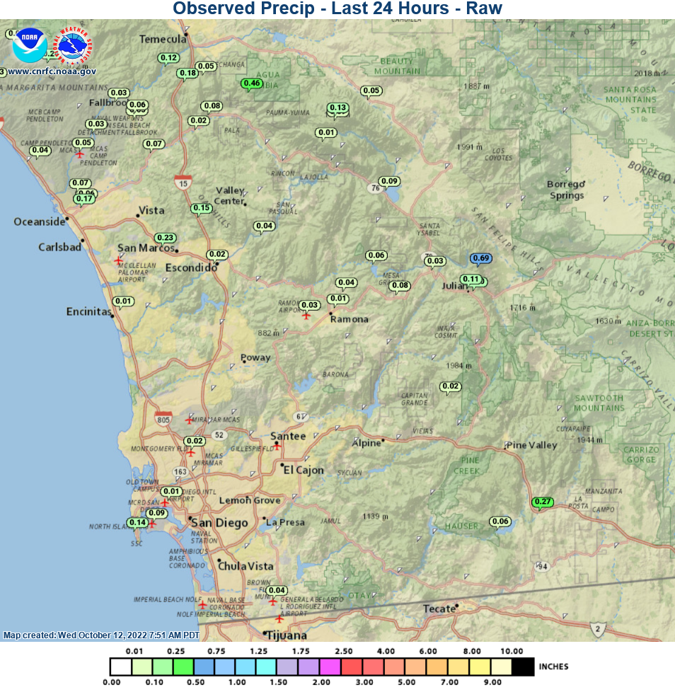
I've posted the computer projected rainfall and snowfall through Sunday afternoon. Most of Southern California is going to get some much needed precipitation soon!


SNOW TOTALS: SUNDAY 12-11-2022 TO MONDAY 12-12-2022

SNOW VALLEY         10-12        7500        07 AM 12/12
BEAR MTN SNOW SUMMIT  9          7100        03 PM 12/12
MOUNT LAGUNA          8          6000        04 PM 12/12
BIG BEAR CITY        4-8         6800        02 PM 12/12
GREEN VALLEY LAKE     7          6900        07 AM 12/12
SUGARLOAF             5          7000        04 PM 12/11
MOUNTAIN HIGH         5          7500        07 AM 12/12
MT BALDY SKI AREA     5          7500        02 PM 12/11
LAKE CUYAMACA         5          4600        03 PM 12/12
BIRCH HILL           4.5         5700        10 AM 12/12
PALOMAR MOUNTAIN     4.5         5500        03 PM 12/12
JULIAN                4          4150        12 PM 12/12
PINE COVE HWY 243     4          6000        01 PM 12/12
WRIGHTWOOD ACORN CYN  4          6000        07 PM 12/12
BARTON FLATS          3          6900        07 AM 12/12
FOREST FALLS          3          5900        07 AM 12/12
BIG BEAR YARD         3          6800        07 AM 12/12
FERN VALLEY           3          5900        10 AM 12/12
PINE COVE DUTCH FLAT 2-3       5800-6100     10 AM 12/12
IDYLLWILD            2.5         5400        02 PM 12/12
LAKE ARROWHEAD        2          5170        07 AM 12/12
ARROWBEAR LAKE        2          6190        07 AM 12/12
RUNNING SPRINGS       2          6200        07 AM 12/12
WRIGHTWOOD            2          5900        07 PM 12/12
CRESTLINE             1          4597        07 AM 12/12
END OF MT BALDY RD    1          6300        07 AM 12/12
ANGELUS OAKS          1          5780        07 AM 12/12
DESCANSO              1          3573        09 AM 12/12


SAN DIEGO RAIN TOTALS: SUNDAY 12-11-2022 TO MONDAY 12-12-2022


Agua Caliente (AGUC1)0.02
Alpine (ANEC1)1.41
Barona (BNAC1)0.95
Barret Lake (BRTC1)0.78
Barrett Junction (BAJC1)1.01
Birch Hill (IRCC1)1.45
Bonita (BNNC1)1.06
Bonsall (BOSC1)0.94
Borrego Palm Canyon (BRPC1)0.01
Borrego Springs (BGOC1)0.00
Cactus County Park (CCPC1)1.01
Cameron Guard Station (CMNC1)0.09
Camp Elliot (MPEC1)1.41
Camp Pendleton (PPDC1)0.91
Campo (CMFC1)1.28
Case Springs (CSPC1)2.16
CMP Target Range (CTGC1)1.02
Core Grade Road (OLEC1)0.96
Couser Canyon (OUSC1)1.22
Coyote Cyn Creek (CCYC1)0.05
Cuyamaca Reservoir (CYDC1)2.08
Deer Springs (DRGC1)1.05
Descanso (DENC1)1.74
Descanso RS (DSCC1)2.11
Dulzura Summit (DULC1)0.00
Eastern Tanks (ETKC1)1.65
Echo Dell (ECDC1)1.42
El Camino Del Norte (ECMC1)0.76
El Capitan Dam (ELPC1)1.20
Encinitas (ENCC1)0.80
Escondido (ESOC1)1.16
Fallbrook 5NE (FBOC1)1.27
Fallbrook (FBZC1)1.25
Fallbrook (FLBC1)0.04
Fallbrook Community AP (L18)0.96
Fashion Valley (FSNC1)1.10
Flinn Springs (FLYC1)1.23
Goose Valley (GOSC1)1.26
Granite Hills (GRHC1)1.16
Harbison Canyon (HARC1)1.44
Henshaw Dam (HAWC1)1.92
Japatul Fire Station (JFSC1)1.75
Julian (JLNC1)1.83
Julian (JULC1)1.88
Kearny Mesa (KEAC1)1.10
La Jolla Amago (LJOC1)0.25
La Mesa (LMSC1)0.96
Lake Hodges (HODC1)0.90
Lake Morena (MRAC1)1.39
Lakeside / El Cajon (LCKC1)1.10
Las Flores (LSFC1)1.00
Lindbergh Int'l Airport (SAN)0.92
Loma Tova (LMTB1)0.16
Lower Oat Flats (OFLC1)1.85
Marron Valley (MAVC1)0.79
Mesa Grande (MEGC1)2.58
Miramar Lake (MMRC1)0.97
Mission Valley (BVDC1)1.04
Missle (MSXC1)1.42
Montgomery Field (MYF)0.96
Mount Laguna (LGMC1)0.58
Mount Laguna (MLGC1)0.84
Mt Woodson Rd - Ramona (RMAC1)1.46
North Island NAS (NZY)0.52
Oak Grove (OGVC1)0.90
Oceanside (OCNC1)1.10
Otay Mountain (OTYC1)1.61
Pala 2W (PZAC1)1.15
Palomar Airport (PLMC1)1.01
Palomar Mountain (PRMC1)2.58
Palomar Mountain CRS (PMMC1)2.03
Palomar Mountain USFS (PAMC1)2.24
Pine Hills Fire Station (PHIC1)2.62
Pine Valley County Park (PNVC1)1.86
Point Loma (L13)0.58
Potrero (PRCC1)1.71
Potrero CDF (POTC1)1.52
Poway (PWYC1)0.97
Rainbow Camp (RAIC1)1.92
Rainbow County Park (RABC1)1.48
Ramona (RMNC1)1.25
Ramona (RNM)1.17
Ranchita (RTAC1)0.55
Ranchita CDF (RCHC1)0.43
Ranchita Margarita (RMGC1)2.15
Rancho Bernardo (RNBC1)1.04
Red Gate Repeater (RGPC1)1.06
Rincon Springs (RINC1)0.74
Roads Division 1 HQ (RDHC1)0.82
San Diego Estates (ESTC1)1.18
San Felipe Valley (SFVC1)0.23
San Marcos Cnty Rd Station (SMXC1)1.01
San Marcos Landfill (NMLC1)0.81
San Miguel (MIGC1)0.94
San Pasqual (PSQC1)0.94
Santa Rosa Plateau (SRUC1)2.19
Santa Ysabel (SYSC1)1.73
Santee - Mast Rd (STEC1)1.05
Skyline Ranch (SKLC1)1.44
Sutherland Dam (SUDC1)1.80
Talega (TLGC1)1.35
Temecula (TEMC1)1.46
Thousand Trails - Jamul (TTRC1)1.04
Tierra Del Sol (TRRC1)0.93
Valley Center (VALC1)1.19
Valley Center (VLCC1)1.20
Volcan Mountain (VCNC1)1.29
Warner Springs (WSGC1)0.90
Wire Mountain (WIRC1)1.11
Witch Creek Fire Station (WCHC1)1.68
Wohlford Dam (WHLC1)1.53


NEXT RAIN CHANCE SAN DIEGO: UPDATED FRIDAY 12-9-2022

Our next storm system is moving out of the Gulf of Alaska and will bring rain to the area Sunday into Monday. You can spot it spiraling in the satellite image below. 

Showers will develop late Saturday night into early Sunday morning. Intermittent showers and isolated downpours will be possible through midday Monday, then we should be dry by Monday afternoon.

Snow levels will start at 7,000-8,000 feet Sunday, then drop to 4,000-5,000 feet Sunday night. Levels will then finish at 3,000-4,000 feet as the system exits early Monday.

I've posted rain and snow projections in the maps below. Rain totals will range from 1-2" and a few inches of snow accumulation will be possible in the highest peaks in our area.


NEXT RAIN CHANCE SAN DIEGO: UPDATED FRIDAY 12-2-2022

Skies are turbulent in the Pacific Ocean. There are a few small storm systems, which can be spotted in the satellite loop below. The most notable is the one diving out of the Gulf of Alaska. 

A brief shower could pop up over the weekend and Monday, but the chances look slim. A slightly better chance for rain will arrive late Monday into Tuesday as that Gulf system passes over head. However, rain chances are only low to moderate. This has been a difficult storm to predict, so I'll bring updates if needed.

I've posted computer projected rain and snow totals through next Wednesday morning. These maps show that most precipitation will remain north of our area. It's still great to see rain and snow in the Central Coast and Sierra's, which is much needed!


SAN DIEGO RAIN TOTALS: MONDAY 11-7-2022 TO WEDNESDAY 11-9-2022

Agua Caliente (AGUC1)0.00
Alpine (ANEC1)2.77
Barona (BNAC1)1.95
Barret Lake (BRTC1)2.18
Barrett Junction (BAJC1)2.62
Birch Hill (IRCC1)4.14
Bonita (BNNC1)1.66
Bonsall (BOSC1)2.24
Borrego Palm Canyon (BRPC1)0.00
Borrego Springs (BGOC1)0.00
Brown Field (SDM)2.28
Cactus County Park (CCPC1)1.56
Cameron Guard Station (CMNC1)1.22
Camp Elliot (MPEC1)1.05
Camp Pendleton (PPDC1)1.38
Campo (CMFC1)1.11
Case Springs (CSPC1)3.06
CMP Target Range (CTGC1)1.27
Core Grade Road (OLEC1)1.93
Couser Canyon (OUSC1)2.03
Coyote Cyn Creek (CCYC1)0.16
Cuyamaca Reservoir (CYDC1)4.66
Deer Springs (DRGC1)1.88
Descanso (DENC1)2.61
Descanso RS (DSCC1)3.06
Dulzura Summit (DULC1)0.00
Eastern Tanks (ETKC1)3.23
Echo Dell (ECDC1)2.90
El Cajon (LCKC1)2.15
El Camino Del Norte (ECMC1)1.19
El Capitan Dam (ELPC1)2.76
Encinitas (ENCC1)1.39
Escondido (ESOC1)2.10
Fallbrook (FBZC1)1.71
Fallbrook (FLBC1)2.04
Fallbrook Community AP (L18)1.57
Fashion Valley (FSNC1)1.00
Flinn Springs (FLYC1)2.91
Goose Valley (GOSC1)1.47
Granite Hills (GRHC1)2.37
Harbison Canyon (HARC1)3.06
Henshaw Dam (HAWC1)4.20
Imperial Beach (TIXC1)0.91
Japatul Fire Station (JFSC1)1.94
Julian (JLNC1)4.31
Julian (JULC1)4.03
Kearny Mesa (KEAC1)0.95
La Jolla Amago (LJOC1)3.54
La Mesa (LMSC1)1.61
Lake Hodges (HODC1)1.48
Lake Morena (MRAC1)2.14
Las Flores (LSFC1)1.41
Lindbergh Int'l Airport (SAN)1.00
Loma Tova (LMTB1)0.31
Lower Oat Flats (OFLC1)3.02
Marron Valley (MAVC1)1.22
Mesa Grande (MEGC1)3.83
Miramar Lake (MMRC1)1.07
Mission Valley (BVDC1)1.03
Missle (MSXC1)1.37
Montgomery Field (MYF)0.82
Mount Laguna (LGMC1)1.55
Mount Laguna (MLGC1)1.81
Mt Woodson Rd - Ramona (RMAC1)2.16
Oak Grove (OGVC1)2.48
Oceanside (OCNC1)1.25
Oceanside (OKB)1.40
Otay Mountain (OTYC1)3.78
Pala 2W (PZAC1)2.10
Palomar Airport (CRQ)1.12
Palomar Airport (PLMC1)1.19
Palomar Mountain (PRMC1)6.87
Palomar Mountain CRS (PMMC1)4.33
Palomar Mountain USFS (PAMC1)6.14
Pine Hills (PIHC1)4.29
Pine Hills Fire Station (PHIC1)4.50
Pine Valley County Park (PNVC1)2.28
Point Loma (L13)0.79
Potrero (PRCC1)1.78
Potrero CDF (POTC1)1.38
Poway (PWYC1)1.34
Rainbow Camp (RAIC1)2.62
Rainbow County Park (RABC1)2.23
Ramona (RMNC1)1.84
Ramona (RNM)1.64
Ranchita (RTAC1)1.12
Ranchita CDF (RCHC1)0.91
Ranchita Margarita (RMGC1)3.89
Rancho Bernardo (RNBC1)1.42
Red Gate Repeater (RGPC1)2.05
Rincon Springs (RINC1)1.85
Roads Division 1 HQ (RDHC1)1.69
San Diego Estates (ESTC1)2.36
San Felipe Valley (SFVC1)0.32
San Marcos Cnty Rd Station (SMXC1)1.59
San Marcos Landfill (NMLC1)1.09
San Miguel (MIGC1)0.06
San Pasqual (PSQC1)1.39
Santa Rosa Plateau (SRUC1)3.03
Santa Ysabel (SYSC1)2.75
Santee - Mast Rd (STEC1)1.56
Skyline Ranch (SKLC1)3.58
Sutherland Dam (SUDC1)2.29
Talega (TLGC1)1.66
Temecula (TEMC1)1.93
Tierra Del Sol (TRRC1)0.67
Valley Center (VALC1)2.07
Valley Center (VLCC1)2.19
Volcan Mountain (VCNC1)3.66
Warner Springs (WSGC1)1.80
Wire Mountain (WIRC1)1.27
Witch Creek Fire Station (WCHC1)2.90
Wohlford Dam (WHLC1)2.39


NEXT RAIN CHANCE SAN DIEGO: UPDATED SUNDAY 11-6-2022

Our next storm system is currently nestling into the Pacific Northwest - seen on the satellite loop below. Some patches of drizzle or light rain will develop on Monday, but most of the day should be dry.

Rain will then overspread the area on Tuesday and will persist intermittently through Wednesday morning. Rain chances quickly diminish by Wednesday afternoon. I've posted the computer projected rain totals below, which show 1-3" for coastal and inland areas and 3-4" for the mountains.

Snow levels will stay high through this event. On Tuesday they will be above 9,000 feet, then drop to 6,000 feet early Wednesday as the storm exits. This could bring a brief period of snow for the highest peaks in San Diego County, but significant snow for taller mountains to the north. I've posted the projected snow totals below.


SAN DIEGO RAIN TOTALS: WEDNESDAY 11-2-2022 TO THURSDAY 11-3-2022


Agua Caliente (AGUC1)0.05
Alpine (ANEC1)0.31
Barona (BNAC1)0.36
Barret Lake (BRTC1)0.48
Barrett Junction (BAJC1)0.43
Birch Hill (IRCC1)0.41
Bonita (BNNC1)0.07
Bonsall (BOSC1)0.11
Borrego Palm Canyon (BRPC1)0.10
Borrego Springs (BGOC1)0.01
Brown Field (SDM)0.12
Cactus County Park (CCPC1)0.12
Cameron Guard Station (CMNC1)0.61
Camp Elliot (MPEC1)0.20
Campo (CMFC1)0.30
Case Springs (CSPC1)0.07
CMP Target Range (CTGC1)0.14
Core Grade Road (OLEC1)0.07
Couser Canyon (OUSC1)0.05
Coyote Cyn Creek (CCYC1)0.01
Cuyamaca Reservoir (CYDC1)0.72
Deer Springs (DRGC1)0.12
Descanso (DENC1)0.36
Descanso RS (DSCC1)0.56
Dulzura Summit (DULC1)0.00
Eastern Tanks (ETKC1)0.44
Echo Dell (ECDC1)0.28
El Cajon (LCKC1)0.12
El Camino Del Norte (ECMC1)0.17
El Capitan Dam (ELPC1)0.20
Encinitas (ENCC1)0.14
Escondido (ESOC1)0.09
Fallbrook 5NE (FBOC1)0.06
Fallbrook (FBZC1)0.12
Fallbrook (FLBC1)0.02
Fallbrook Community AP (L18)0.03
Fashion Valley (FSNC1)0.12
Flinn Springs (FLYC1)0.14
Goose Valley (GOSC1)0.30
Granite Hills (GRHC1)0.09
Harbison Canyon (HARC1)0.10
Henshaw Dam (HAWC1)0.18
Japatul Fire Station (JFSC1)0.50
Julian (JLNC1)0.89
Julian (JULC1)0.73
Kearny Mesa (KEAC1)0.12
La Jolla Amago (LJOC1)0.16
La Mesa (LMSC1)0.10
Lake Hodges (HODC1)0.25
Lake Morena (MRAC1)0.91
Las Flores (LSFC1)0.15
Loma Tova (LMTB1)0.00
Lower Oat Flats (OFLC1)0.06
Marron Valley (MAVC1)0.20
MCOLF - Red Beach (NXF)0.00
Mesa Grande (MEGC1)0.37
Miramar Lake (MMRC1)0.10
Miramar Marine Corps Station (NKX)0.01
Mission Valley (BVDC1)0.09
Missle (MSXC1)0.17
Montgomery Field (MYF)0.14
Mount Laguna (LGMC1)0.98
Mount Laguna (MLGC1)0.75
Mt Woodson Rd - Ramona (RMAC1)0.32
Oak Grove (OGVC1)0.12
Oceanside (OCNC1)0.25
Oceanside (OKB)0.26
Otay Mountain (OTYC1)0.17
Pala 2W (PZAC1)0.02
Palomar Airport (CRQ)0.08
Palomar Airport (PLMC1)0.07
Palomar Mountain CRS (PMMC1)0.37
Palomar Mountain USFS (PAMC1)0.54
Pine Hills (PIHC1)0.60
Pine Hills Fire Station (PHIC1)0.62
Pine Valley County Park (PNVC1)0.82
Point Loma (L13)0.14
Potrero (PRCC1)0.47
Potrero CDF (POTC1)0.46
Poway (PWYC1)0.02
Rainbow Camp (RAIC1)0.05
Rainbow County Park (RABC1)0.04
Ramona (RMNC1)0.30
Ramona (RNM)0.18
Ranchita (RTAC1)0.19
Ranchita CDF (RCHC1)0.23
Ranchita Margarita (RMGC1)0.39
Rancho Bernardo (RNBC1)0.09
Red Gate Repeater (RGPC1)0.12
Rincon Springs (RINC1)0.10
Roads Division 1 HQ (RDHC1)0.04
San Diego Estates (ESTC1)0.39
San Felipe Valley (SFVC1)0.67
San Marcos Cnty Rd Station (SMXC1)0.08
San Marcos Landfill (NMLC1)0.16
San Miguel (MIGC1)0.03
San Pasqual (PSQC1)0.22
Santa Rosa Plateau (SRUC1)0.10
Santa Ysabel (SYSC1)0.41
Santee - Mast Rd (STEC1)0.22
Skyline Ranch (SKLC1)0.11
Sutherland Dam (SUDC1)0.52
Talega (TLGC1)0.07
Temecula (TEMC1)0.04
Thousand Trails - Jamul (TTRC1)0.15
Tierra Del Sol (TRRC1)0.32
Valley Center (VALC1)0.08
Valley Center (VLCC1)0.05
Volcan Mountain (VCNC1)0.87
Warner Springs (WSGC1)0.20
Wire Mountain (WIRC1)0.31
Witch Creek Fire Station (WCHC1)0.41
Wohlford Dam (WHLC1)0.10


NEXT RAIN CHANCE SAN DIEGO: UPDATED MONDAY 10-31-2022

Our first winter-like storm system will pass the area Wednesday into Thursday, bringing a quick chance for light showers and a little snow in the mountains.

The system is currently spinning in the Gulf of Alaska and will dive southeastward in the next couple days. Unfortunately, most of  the energy will miss us to the east, which will greatly impact the rain potential.

Light showers are possible early Wednesday. Then another round of showers will develop Thursday evening and will persist intermittently through Thursday morning. Most of the rain will be gone by midday Thursday. Coastal and inland areas will receive around 0.25" of rain, while mountain areas will get 0.5 to 1.0". I've posted the computer projected rain totals below.

Snow levels will drop to near 5,000 feet early Thursday, so some local mountains will get light snow. The ground is still very warm, so no accumulations are expected. 


SAN DIEGO RAIN TOTALS: SATURDAY 10-22-2022


Agua Caliente (AGUC1)0.00
Alpine (ANEC1)0.45
Barona (BNAC1)0.16
Barret Lake (BRTC1)0.17
Barrett Junction (BAJC1)0.22
Birch Hill (IRCC1)0.66
Bonita (BNNC1)0.22
Bonsall (BOSC1)0.10
Borrego Palm Canyon (BRPC1)0.05
Borrego Springs (BGOC1)0.00
Brown Field (SDM)0.12
Cactus County Park (CCPC1)0.11
Cameron Guard Station (CMNC1)0.32
Camp Elliot (MPEC1)0.17
Camp Pendleton (NFG)0.06
Camp Pendleton (PPDC1)0.13
Campo (CMFC1)0.20
Case Springs (CSPC1)0.18
CMP Target Range (CTGC1)0.10
Core Grade Road (OLEC1)0.08
Couser Canyon (OUSC1)0.08
Coyote Cyn Creek (CCYC1)0.00
Cuyamaca Reservoir (CYDC1)0.70
Deer Springs (DRGC1)0.13
Descanso (DENC1)0.49
Descanso RS (DSCC1)0.58
Dulzura Summit (DULC1)0.00
Eastern Tanks (ETKC1)0.47
Echo Dell (ECDC1)0.21
El Cajon (LCKC1)0.12
El Camino Del Norte (ECMC1)0.06
El Capitan Dam (ELPC1)0.37
Encinitas (ENCC1)0.07
Escondido (ESOC1)0.12
Fallbrook (FBZC1)0.13
Fallbrook (FLBC1)0.10
Fallbrook Community AP (L18)0.09
Fashion Valley (FSNC1)0.08
Flinn Springs (FLYC1)0.21
Goose Valley (GOSC1)0.16
Granite Hills (GRHC1)0.07
Harbison Canyon (HARC1)0.29
Henshaw Dam (HAWC1)0.49
Japatul Fire Station (JFSC1)0.22
Julian (JLNC1)0.53
Julian (JULC1)0.55
Kearny Mesa (KEAC1)0.18
La Jolla Amago (LJOC1)0.02
La Mesa (LMSC1)0.13
Lake Hodges (HODC1)0.12
Lake Morena (MRAC1)0.30
Las Flores (LSFC1)0.16
Lindbergh Int'l Airport (SAN)0.05
Loma Tova (LMTB1)0.00
Lower Oat Flats (OFLC1)0.15
Marron Valley (MAVC1)0.16
MCOLF - Red Beach (NXF)0.00
Mesa Grande (MEGC1)0.54
Miramar Lake (MMRC1)0.15
Miramar Marine Corps Station (NKX)0.12
Mission Valley (BVDC1)0.12
Missle (MSXC1)0.15
Montgomery Field (MYF)0.08
Mount Laguna (LGMC1)0.26
Mount Laguna (MLGC1)0.33
Mt Woodson Rd - Ramona (RMAC1)0.41
Oak Grove (OGVC1)0.00
Oceanside (OCNC1)0.05
Oceanside (OKB)0.06
Pala 2W (PZAC1)0.12
Palomar Airport (CRQ)0.04
Palomar Airport (PLMC1)0.02
Palomar Mountain (PRMC1)0.33
Palomar Mountain CRS (PMMC1)0.90
Pine Hills (PIHC1)0.44
Pine Hills Fire Station (PHIC1)0.45
Pine Valley County Park (PNVC1)0.45
Point Loma (L13)0.02
Potrero (PRCC1)0.30
Potrero CDF (POTC1)0.21
Poway (PWYC1)0.12
Rainbow Camp (RAIC1)0.21
Rainbow County Park (RABC1)0.19
Ramona (RMNC1)0.26
Ramona (RNM)0.20
Ranchita (RTAC1)0.06
Ranchita CDF (RCHC1)0.11
Ranchita Margarita (RMGC1)0.35
Rancho Bernardo (RNBC1)0.23
Red Gate Repeater (RGPC1)0.20
Rincon Springs (RINC1)0.16
Roads Division 1 HQ (RDHC1)0.16
San Diego Estates (ESTC1)0.20
San Felipe Valley (SFVC1)0.00
San Marcos Cnty Rd Station (SMXC1)0.09
San Marcos Landfill (NMLC1)0.07
San Miguel (MIGC1)0.13
San Pasqual (PSQC1)0.10
Santa Rosa Plateau (SRUC1)0.08
Santa Ysabel (SYSC1)0.41
Santee - Mast Rd (STEC1)0.16
Skyline Ranch (SKLC1)0.20
Sutherland Dam (SUDC1)0.39
Talega (TLGC1)0.08
Temecula (TEMC1)0.03
Thousand Trails - Jamul (TTRC1)0.27
Tierra Del Sol (TRRC1)0.15
Valley Center (VALC1)0.15
Volcan Mountain (VCNC1)0.63
Warner Springs (WSGC1)0.18
Wire Mountain (WIRC1)0.00
Witch Creek Fire Station (WCHC1)0.41
Wohlford Dam (WHLC1)0.07


SAN DIEGO RAIN TOTALS: SATURDAY 10-15-2022 TO SUNDAY 10-16-2022


Agua Caliente (AGUC1)0.19
Alpine (ANEC1)0.24
Barona (BNAC1)0.38
Barret Lake (BRTC1)0.08
Barrett Junction (BAJC1)0.07
Birch Hill (IRCC1)0.28
Bonita (BNNC1)0.00
Bonsall (BOSC1)0.03
Borrego Palm Canyon (BRPC1)0.39
Borrego Springs (BGOC1)0.34
Brown Field (SDM)0.00
Cactus County Park (CCPC1)0.16
Cameron Guard Station (CMNC1)0.18
Camp Elliot (MPEC1)0.11
Camp Pendleton (PPDC1)0.11
Campo (CMFC1)0.10
Case Springs (CSPC1)0.45
CMP Target Range (CTGC1)0.22
Core Grade Road (OLEC1)0.14
Couser Canyon (OUSC1)0.07
Coyote Cyn Creek (CCYC1)1.28
Cuyamaca Reservoir (CYDC1)1.95
Deer Springs (DRGC1)0.07
Descanso (DENC1)0.25
Descanso RS (DSCC1)0.26
Dulzura Summit (DULC1)0.00
Eastern Tanks (ETKC1)0.28
Echo Dell (ECDC1)0.18
El Cajon (LCKC1)0.13
El Camino Del Norte (ECMC1)0.01
El Capitan Dam (ELPC1)0.12
Encinitas (ENCC1)0.00
Escondido (ESOC1)0.05
Fallbrook 5NE (FBOC1)0.06
Fallbrook (FBZC1)0.09
Fallbrook (FLBC1)0.05
Fallbrook Community AP (L18)0.03
Fashion Valley (FSNC1)0.01
Flinn Springs (FLYC1)0.14
Goose Valley (GOSC1)0.35
Granite Hills (GRHC1)0.10
Harbison Canyon (HARC1)0.15
Henshaw Dam (HAWC1)0.39
Japatul Fire Station (JFSC1)0.10
Julian (JLNC1)1.10
Julian (JULC1)0.95
Kearny Mesa (KEAC1)0.09
La Jolla Amago (LJOC1)0.00
La Mesa (LMSC1)0.10
Lake Hodges (HODC1)0.05
Lake Morena (MRAC1)0.11
Las Flores (LSFC1)0.22
Lindbergh Int'l Airport (SAN)0.01
Loma Tova (LMTB1)0.00
Lower Oat Flats (OFLC1)0.23
Marron Valley (MAVC1)0.00
Mesa Grande (MEGC1)0.44
Miramar Lake (MMRC1)0.05
Mission Valley (BVDC1)0.07
Missle (MSXC1)0.11
Montgomery Field (MYF)0.05
Mount Laguna (LGMC1)0.24
Mount Laguna (MLGC1)0.23
Mt Woodson Rd - Ramona (RMAC1)0.18
Oak Grove (OGVC1)0.42
Oceanside (OCNC1)0.04
Otay Mountain (OTYC1)0.01
Pala 2W (PZAC1)0.16
Palomar Airport (CRQ)0.01
Palomar Airport (PLMC1)0.01
Palomar Mountain (PRMC1)0.30
Palomar Mountain CRS (PMMC1)0.31
Palomar Mountain USFS (PAMC1)0.39
Pine Hills (PIHC1)0.71
Pine Hills Fire Station (PHIC1)0.68
Pine Valley County Park (PNVC1)0.19
Point Loma (L13)0.04
Potrero (PRCC1)0.03
Potrero CDF (POTC1)0.02
Poway (PWYC1)0.05
Rainbow Camp (RAIC1)0.07
Rainbow County Park (RABC1)0.06
Ramona (RMNC1)0.37
Ramona (RNM)0.24
Ranchita (RTAC1)0.57
Ranchita CDF (RCHC1)0.54
Ranchita Margarita (RMGC1)0.62
Rancho Bernardo (RNBC1)0.07
Red Gate Repeater (RGPC1)0.27
Rincon Springs (RINC1)0.22
Roads Division 1 HQ (RDHC1)0.03
San Diego Estates (ESTC1)0.51
San Felipe Valley (SFVC1)0.51
San Marcos Cnty Rd Station (SMXC1)0.04
San Marcos Landfill (NMLC1)0.02
San Miguel (MIGC1)0.00
San Pasqual (PSQC1)0.12
Santa Rosa Plateau (SRUC1)0.15
Santa Ysabel (SYSC1)0.62
Santee - Mast Rd (STEC1)0.14
Skyline Ranch (SKLC1)0.22
Sutherland Dam (SUDC1)0.55
Talega (TLGC1)0.31
Temecula (TEMC1)0.04
Thousand Trails - Jamul (TTRC1)0.00
Tierra Del Sol (TRRC1)0.14
Valley Center (VALC1)0.15
Valley Center (VLCC1)0.17
Volcan Mountain (VCNC1)1.09
Warner Springs (WSGC1)0.48
Wire Mountain (WIRC1)0.06
Witch Creek Fire Station (WCHC1)0.54
Wohlford Dam (WHLC1)0.08


NEXT RAIN CHANCE SAN DIEGO: UPDATED FRIDAY 10-14-2022

A storm system continues to churn off our coast, bringing clouds to our area this morning. You can see it spinning in the satellite loop below. The core of this system is finally going to drift overhead and bring us some more rain to the area.

Drizzle and isolated light showers are possible through today, though most of the day looks dry. Then intermittent showers will be possible Friday night and through the day on Saturday. An isolated thunderstorm or quick downpour will also be possible, especially in the mountains. This won't be a major rain event, but we'll take whatever we can get!

Rain chances will diminish by Sunday morning. I've posted the computer projected rain totals below.


SAN DIEGO RAIN TOTALS: TUESDAY 10-11-2022


Agua Caliente (AGUC1)0.00
Alpine (ANEC1)0.00
Barona (BNAC1)0.00
Barret Lake (BRTC1)0.00
Barrett Junction (BAJC1)0.00
Birch Hill (IRCC1)0.00
Bonita (BNNC1)0.00
Bonsall (BOSC1)0.07
Borrego Palm Canyon (BRPC1)0.00
Borrego Springs (BGOC1)0.00
Brown Field (SDM)0.04
Cactus County Park (CCPC1)0.00
Cameron Guard Station (CMNC1)0.27
Camp Elliot (MPEC1)0.00
Camp Pendleton (NFG)0.05
Camp Pendleton (PPDC1)0.03
Campo (CMFC1)0.00
Case Springs (CSPC1)0.24
CMP Target Range (CTGC1)0.00
Core Grade Road (OLEC1)0.00
Couser Canyon (OUSC1)0.02
Coyote Cyn Creek (CCYC1)0.00
Cuyamaca Reservoir (CYDC1)0.00
Deer Springs (DRGC1)0.15
Descanso (DENC1)0.00
Descanso RS (DSCC1)0.00
Dulzura Summit (DULC1)0.00
Eastern Tanks (ETKC1)0.00
Echo Dell (ECDC1)0.02
El Cajon (LCKC1)0.00
El Camino Del Norte (ECMC1)0.00
El Capitan Dam (ELPC1)0.00
Encinitas (ENCC1)0.01
Escondido (ESOC1)0.02
Fallbrook 5NE (FBOC1)0.12
Fallbrook (FBZC1)0.03
Fallbrook (FLBC1)0.06
Fallbrook Community AP (L18)0.05
Fashion Valley (FSNC1)0.00
Flinn Springs (FLYC1)0.00
Goose Valley (GOSC1)0.04
Granite Hills (GRHC1)0.00
Harbison Canyon (HARC1)0.00
Henshaw Dam (HAWC1)0.09
Japatul Fire Station (JFSC1)0.00
Julian (JLNC1)0.11
Julian (JULC1)0.10
Kearny Mesa (KEAC1)0.00
La Jolla Amago (LJOC1)0.00
La Mesa (LMSC1)0.00
Lake Hodges (HODC1)0.00
Lake Morena (MRAC1)0.06
Las Flores (LSFC1)0.04
Lindbergh Int'l Airport (SAN)0.01
Loma Tova (LMTB1)0.00
Lower Oat Flats (OFLC1)0.46
Marron Valley (MAVC1)0.00
MCOLF - Red Beach (NXF)0.00
Mesa Grande (MEGC1)0.00
Miramar Lake (MMRC1)0.00
Miramar Marine Corps Station (NKX)0.00
Mission Valley (BVDC1)0.00
Missle (MSXC1)0.00
Montgomery Field (MYF)0.02
Mount Laguna (LGMC1)0.00
Mount Laguna (MLGC1)0.00
Mt Woodson Rd - Ramona (RMAC1)0.00
North Island NAS (NZY)0.09
Oak Grove (OGVC1)0.05
Oceanside (OCNC1)0.17
Oceanside (OKB)0.06
Otay Mountain (OTYC1)0.00
Pala 2W (PZAC1)0.08
Palomar Airport (CRQ)0.00
Palomar Airport (PLMC1)0.00
Palomar Mountain (PRMC1)0.13
Palomar Mountain CRS (PMMC1)0.01
Palomar Mountain USFS (PAMC1)0.09
Pine Hills (PIHC1)0.00
Pine Hills Fire Station (PHIC1)0.00
Pine Valley County Park (PNVC1)0.00
Point Loma (L13)0.14
Potrero CDF (POTC1)0.00
Poway (PWYC1)0.00
Rainbow Camp (RAIC1)0.05
Rainbow County Park (RABC1)0.18
Ramona (RMNC1)0.01
Ramona (RNM)0.03
Ranchita (RTAC1)0.00
Ranchita CDF (RCHC1)0.00
Ranchita Margarita (RMGC1)0.00
Rancho Bernardo (RNBC1)0.00
Red Gate Repeater (RGPC1)0.00
Rincon Springs (RINC1)0.00
Roads Division 1 HQ (RDHC1)0.00
San Diego Estates (ESTC1)0.00
San Felipe Valley (SFVC1)0.00
San Marcos Cnty Rd Station (SMXC1)0.23
San Marcos Landfill (NMLC1)0.00
San Miguel (MIGC1)0.00
San Pasqual (PSQC1)0.00
Santa Rosa Plateau (SRUC1)0.05
Santa Ysabel (SYSC1)0.03
Santee - Mast Rd (STEC1)0.00
Skyline Ranch (SKLC1)0.00
Sutherland Dam (SUDC1)0.06
Talega (TLGC1)0.09
Temecula (TEMC1)0.00
Tierra Del Sol (TRRC1)0.00
Valley Center (VALC1)0.00
Valley Center (VLCC1)0.00
Volcan Mountain (VCNC1)0.69
Warner Springs (WSGC1)0.00
Wire Mountain (WIRC1)0.07
Witch Creek Fire Station (WCHC1)0.08
Wohlford Dam (WHLC1)0.04


SAN DIEGO RAIN TOTALS: FRIDAY 9-9-2022 TO SATURDAY 9-10-2022


Agua Caliente (AGUC1)3.82
Alpine (ANEC1)0.15
Barona (BNAC1)0.04
Barret Lake (BRTC1)0.21
Barrett Junction (BAJC1)0.17
Birch Hill (IRCC1)1.04
Bonita (BNNC1)0.16
Bonsall (BOSC1)0.35
Borrego Palm Canyon (BRPC1)1.40
Borrego Springs (BGOC1)1.37
Brown Field (SDM)0.20
Cactus County Park (CCPC1)0.07
Cameron Guard Station (CMNC1)0.89
Camp Elliot (MPEC1)0.50
Camp Pendleton (NFG)0.23
Camp Pendleton (PPDC1)0.30
Campo (CMFC1)0.40
Case Springs (CSPC1)0.41
CMP Target Range (CTGC1)0.28
Core Grade Road (OLEC1)0.21
Couser Canyon (OUSC1)0.47
Coyote Cyn Creek (CCYC1)1.25
Cuyamaca Reservoir (CYDC1)1.93
Deer Springs (DRGC1)0.20
Descanso (DENC1)0.20
Descanso RS (DSCC1)0.23
Dulzura Summit (DULC1)0.08
Eastern Tanks (ETKC1)0.83
Echo Dell (ECDC1)0.17
El Cajon (LCKC1)0.05
El Camino Del Norte (ECMC1)0.20
El Capitan Dam (ELPC1)0.07
Encinitas (ENCC1)0.16
Escondido (ESOC1)0.20
Fallbrook 5NE (FBOC1)0.48
Fallbrook (FBZC1)0.22
Fallbrook (FLBC1)0.27
Fallbrook Community AP (L18)0.17
Fashion Valley (FSNC1)0.49
Flinn Springs (FLYC1)0.08
Goose Valley (GOSC1)0.37
Granite Hills (GRHC1)0.03
Harbison Canyon (HARC1)0.03
Henshaw Dam (HAWC1)0.23
Imperial Beach (TIXC1)0.40
Japatul Fire Station (JFSC1)0.18
Julian (JLNC1)3.46
Julian (JULC1)3.29
Kearny Mesa (KEAC1)0.40
La Jolla Amago (LJOC1)0.16
La Mesa (LMSC1)0.36
Lake Hodges (HODC1)0.14
Lake Morena (MRAC1)0.49
Las Flores (LSFC1)0.30
Lindbergh Int'l Airport (SAN)0.61
Loma Tova (LMTB1)0.00
Lower Oat Flats (OFLC1)0.53
Marron Valley (MAVC1)0.04
Mesa Grande (MEGC1)0.21
Miramar Lake (MMRC1)0.31
Miramar Marine Corps Station (NKX)0.32
Mission Valley (BVDC1)0.26
Missle (MSXC1)0.34
Montgomery Field (MYF)0.35
Mount Laguna (LGMC1)4.48
Mount Laguna (MLGC1)4.24
Mt Woodson Rd - Ramona (RMAC1)0.33
North Island NAS (NZY)0.46
Oak Grove (OGVC1)0.31
Oceanside (OCNC1)0.38
Otay Mountain (OTYC1)0.18
Pala 2W (PZAC1)0.41
Palomar Airport (CRQ)0.23
Palomar Airport (PLMC1)0.19
Palomar Mountain (PRMC1)0.93
Palomar Mountain CRS (PMMC1)1.01
Palomar Mountain USFS (PAMC1)1.00
Pine Hills (PIHC1)1.08
Pine Hills Fire Station (PHIC1)1.01
Pine Valley County Park (PNVC1)0.64
Point Loma (L13)0.45
Potrero (PRCC1)0.35
Potrero CDF (POTC1)0.30
Poway (PWYC1)0.15
Rainbow Camp (RAIC1)0.54
Rainbow County Park (RABC1)0.54
Ramona (RMNC1)0.20
Ramona (RNM)0.29
Ranchita (RTAC1)2.77
Ranchita CDF (RCHC1)4.27
Ranchita Margarita (RMGC1)0.32
Rancho Bernardo (RNBC1)0.08
Red Gate Repeater (RGPC1)0.44
Rincon Springs (RINC1)0.32
Roads Division 1 HQ (RDHC1)0.01
San Diego Estates (ESTC1)0.04
San Felipe Valley (SFVC1)2.52
San Marcos Cnty Rd Station (SMXC1)0.36
San Marcos Landfill (NMLC1)0.14
San Miguel (MIGC1)0.07
San Pasqual (PSQC1)0.28
Santa Rosa Plateau (SRUC1)0.59
Santa Ysabel (SYSC1)0.97
Santee - Mast Rd (STEC1)0.46
Skyline Ranch (SKLC1)0.49
Smugglers Gulch (UGGC1)0.39
Sutherland Dam (SUDC1)0.02
Talega (TLGC1)0.44
Temecula (TEMC1)0.39
Tierra Del Sol (TRRC1)1.21
Valley Center (VALC1)0.24
Valley Center (VLCC1)0.21
Volcano Mountain (VCNC1)4.23
Warner Springs (WSGC1)0.93
Wire Mountain (WIRC1)0.42
Witch Creek Fire Station (WCHC1)0.07
Wohlford Dam (WHLC1)0.12


WEATHER UPDATE: 8 AM THURSDAY 9-8-2022

Hurricane Kay continues to move northwestward along the coast of the Baja this morning. The satellite imagery shows a ragged storm with a collapsing eye wall. This storm is weakening. 

Most computer projections have this storm downgrading to a tropical storm in the next 24 hours. The projected path also has Kay eventually turning more westward as it tracks closer to our area.

Kay will still get close enough to San Diego to bring some much needed rainfall. Isolated showers will be possible through today (Thursday). Then, more widespread showers and isolated downpours will develop by Friday morning and persist intermittently through the day.

Some showers will be possible Saturday into early Sunday, especially in the mountains, though they won't we as widespread as Friday. 

It's always tough pinpointing rain totals with a system like this. The slightest shift in track will greatly alter projections. With that said, the computers have been fairly consistent showing roughly 0.5" to 2.0" across the area.

It has been awhile since we've seen rain, so the roads will be slick. Be safe out there!


FORECAST

HOURLY TEMPERATURE FORECAST

COAST INLAND

BLOG ARCHIVE