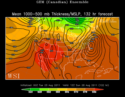
I don't want to downplay this storm too much, though I don't think this storm will have as big of an impact as some forecasts portend. Let's look at the data. I'm going to post the ensemble forecasts of GFS, ECMWF and GEM. The first is from last night's data and the second is from this evening's data. Here are the forecasts for Friday evening:
Now here are the forecasts for Sunday morning:
The data this evening compared to yesterday evening shows a stronger Irene moving faster. In addition, the track has shifted slightly eastward. If these forecasts were to hold true, then Irene would be worse than hurricane Earl last year, but not nearly as bad as Isabel in 2003.
No area would get a direct hit from this storm (the right front quadrant), though North Carolina will be close. This means that the worse storm surge will stay out to sea. Also, there are no signs of this storm slowing down or stalling, which will decrease rain totals.
Lastly, this track would be different than Isabel, which hit the North Carolina coast at almost a 90 degree angle. Isabel also tracked straight into Virginia. Irene doesn't look like it will take this path. Instead, it looks like it will hug the coast, or possibly *just* off the coast. Here is the track of Isabel for reference:
Again, I want to emphasize that I haven't been watching the data too carefully. If you live along the South Carolina, North Carolina or Virginia coasts, you need to watch for the latest info from local meteorologists. However, you should be skeptical of any doomsday forecasts...for now...
Hopefully I will be able to have another update tomorrow.


