
El Niño is a warm ocean current along the equatorial Pacific, while La Niña is a cool current. These currents can have a dramatic impact on weather patterns within the United States, especially during the winter.
The equatorial Pacific is categorized into four regions. Most of the focus is on the area between region 3 and 4, or what is called 3.4, which you can see on the map below. This area is roughly between 120W and 170W along the equator.
| NINO REGIONS ALONG THE EQUATORIAL PACIFIC OCEAN |
 |
The following maps below show the current water temperatures on the surface and also below the surface of the ocean.
| GLOBAL SEA SURFACE ANOMALIES - UPDATED DAILY |
 |
| CURRENT SEA SURFACE TEMPERATURE ANOMALIES - ANIMATED |
 |
ADVERTISEMENT
| CURRENT TEMPERATURE ANOMALIES BELOW SEA SURFACE- ANIMATED |
 |
| CURRENT TEMPERATURE ANOMALIES ACROSS EQUATORIAL PACIFIC |
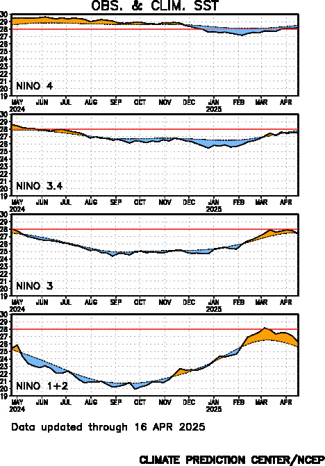 |
The maps below show average temperature and precipitation anomalies for both El Nino and La Nina. For San Diego and Southern California, El Nino can equate to near normal temperatures and above average rainfall. La Nina can bring cooler weather and extremely dry conditions.
Remember, these are averages. Every El Nino and La Nina are unique and there are several other factors that can affect our weather pattern. So take these maps with a grain of salt.
| TEMPERATURE ANOMALY FOR EL NINO YEARS |
 |
| PRECIPITATION ANOMALY FOR EL NINO YEARS |
 |
| TEMPERATURE ANOMALY DURING LA NINA |
 |
| PRECIPITATION ANOMALY DURING LA NINA |
 |
A cool PDO can enhance the effects of La Nina, or decrease the
effects of El Nino. The opposite is true for a warm PDO, which enhances
El Nino and diminishes La Nina. This is accomplished through an
atmospheric bridge (shown below).

I've included two great examples of the ENSO/PDO connection below: November 1988 (La Nina) and November 1997 (El Nino).
| HISTORIC LA NINA IN 1988 |
 |
| HISTORIC EL NINO IN 1997 |
 |
No comments:
Post a Comment