ADVERTISEMENT

WEATHER UPDATE: SATURDAY 12-28-2019

 **Updated to further decrease rain and snow chances on Monday**

Latest computer data is starting to pull the next storm system farther off the coast. If this trend continues, it will dramatically alter our forecast for Monday and Tuesday. At this point, I'll keep rain showers in the forecast on Monday (20%). Tuesday is now looking completely dry.

Snow levels will still hover around 4,500 to 5,000 feet. With the moisture migrating farther east, the chances for snow accumulations are very slim.

I'll keep an eye on this storm and bring more updates if needed. It's a challenging forecast to say the least!


Most moisture is staying off the coast

NEXT RAIN CHANCE SAN DIEGO: UPDATED FRIDAY 12-27-2019

More rain is headed our way for next Monday into early Tuesday (12/30-12/31). A system will dive out of the Gulf of Alaska and glide along the West Coast into our area. You can spot the system in the satellite loop below.

The computer forecasts have been very consistent with this scenario. Showers and isolated downpours will overspread the area Monday morning and persist through most of the day. Showers will still be possible on Tuesday, however, they will be more spotty in nature. We should be dry by Tuesday afternoon. Rain totals could approach 1". I've included a projection below.

Snow levels will start at around 5,000 feet Monday morning, then drop to 4,000 feet by Monday afternoon. Local mountains will get another accumulating snow from this system, though it's still too early to give precise amounts.

As always, get the latest weather warnings from National Weather Service:

https://www.weather.gov/sgx/

And road conditions from Caltrans:

https://roads.dot.ca.gov/

Storm system spinning in the Gulf of Alaska is headed our way


Projected rain totals through next Tuesday

Projected snow totals through next Tuesday

SOUTHERN CALIFORNIA SNOWFALL REPORTS: THURSDAY 12-26-2019

The webcam on top of Mount Laguna shows a healthy amount of snow in our local mountains! Here are the snow reports from yesterday.


        STATION            SNOW(IN)  ELEVATION(FT)  LAST UPDATED

        TOP MT BALDY RD      28          7800       0100 PM THU
        WRIGHTWOOD           25          5900       0630 AM THU
        BIG BEAR RESORT   12-18     6000-7000       0700 PM THU
        CRESTLINE            18          4700       1109 AM THU
        CEDAR PINES PARK     18          5200       1106 AM THU
        LAKE ARROWHEAD NW    15          5600       1100 AM THU
        CRESTLINE (EAST)     14          5000       1108 AM THU
        LAKE ARROWHEAD       13          5300       1112 AM THU
        SKYFOREST            13          5900       1119 AM THU
        BALDWIN LAKE         12          6700       0643 PM THU
        PHELAN               12          3993       0630 AM THU
        RUNNING SPRINGS      12          6200       1114 AM THU
        IDYLLWILD            10-15       5380       0150 PM THU
        PALOMAR MTN          10          5400       0630 AM THU
        BIRCH HILL PALOMAR   10          5600       1130 AM THU
        MT SAN JACINTO-
        LONG VALLEY          10          8400       0930 AM THU
        BIG BEAR CITY         9          6600       0643 PM THU
        PIONEERTOWN           8          4070       1100 AM THU
        JULIAN                8          4215       0345 PM THU
        TWIN PEAKS            8          5200       0430 AM THU
        GREEN VALLEY LAKE     8          6873       0630 AM THU
        OAK HILLS             7          3799       0630 AM THU
        ARROWBEAR LAKE        6          6190       0630 AM THU
        CEDARPINES PARK       4          4700       0700 AM THU
        RANCHITA              4          4100       0645 AM THU
        BALDY MESA            3          3358       0630 AM THU
        VICTORVILLE           3          2726       0630 AM THU
        HESPERIA              2          3212       0400 PM THU
        PINE VALLEY           2          3900       0645 AM THU
        POTRERO               1          2600       0910 AM THU

WEATHER UPDATE: TUESDAY 12-24-2019

A stray shower is possible for this afternoon and evening. Then periods of light to moderate rainfall will be possible on-and-off tonight and through Christmas Day.

However, the heaviest rain is headed this way Wednesday night into early Thursday as the core of the storm system blasts through our area. Rain and isolated downpours will be possible during this time. We should easily receive an additional 1-2" of rainfall.

Snow levels will range from 4,000 to 5,000 feet through most of this event. Local mountains will get a healthy accumulation of snow. Current computer projections have Cuyamaca getting well over a foot of snow. Taller mountains to the north (San Jacinto and San Bernardino) will approach 3 feet of snow. I've included the rain and snow projections below.

Rain and snow will dissipate by Friday morning. Afterwards, I'm watching for another chance for rain headed this way  Monday 12/30.

NAM rain projections through Friday morning

NAM snow projections through Friday


RPM snow projections through Thursday afternoon

SAN DIEGO RAIN TOTALS: MONDAY 12-23-2019 TO THURSDAY 12-26-2019

I'm going to use this blog post to keep a running total of rainfall from Monday 12/23 to Thursday 12/26.

Here is the last update at 7 AM Friday.


Alpine (ANEC1)2.12
Barona (BNAC1)1.90
Barret Lake (BRTC1)2.16
Barrett Junction (BAJC1)2.36
Birch Hill (IRCC1)1.01
Bonita (BNNC1)2.42
Bonsall (BOSC1)1.99
Brown Field (SDM)2.93
Cactus County Park (CCPC1)1.89
Cuyamaca Reservoir (CYDC1)2.46
Deer Springs (DRGC1)2.62
Descanso (DENC1)2.38
Descanso RS (DSCC1)2.00
Dulzura Summit (DULC1)2.62
Echo Dell (ECDC1)2.42
El Cajon (LCKC1)1.92
El Camino Del Norte (ECMC1)2.24
El Capitan Dam (ELPC1)1.51
Encinitas (ENCC1)2.71
Escondido (ESOC1)3.33
Fashion Valley (FSNC1)2.41
Flinn Springs (FLYC1)1.88
Goose Valley (GOSC1)1.98
Granite Hills (GRHC1)1.78
Harbison Canyon (HARC1)1.70
Henshaw Dam (HAWC1)2.15
Julian (JLNC1)1.55
Julian (JULC1)1.82
Kearny Mesa (KEAC1)2.67
La Jolla Amago (LJOC1)2.04
La Mesa (LMSC1)2.14
Lake Hodges (HODC1)3.07
Las Flores (LSFC1)2.77
Lindbergh Int'l Airport (SAN)2.63
Marron Valley (MAVC1)1.42
Mesa Grande (MEGC1)2.09
Miramar Lake (MMRC1)2.75
Mission Valley (BVDC1)2.54
Montgomery Field (MYF)2.38
Mt Woodson Rd - Ramona (RMAC1)2.43
Oceanside (OCNC1)2.78
Oceanside (OKB)2.27
Palomar Airport (CRQ)2.33
Palomar Airport (PLMC1)2.18
Palomar Mountain CRS (PMMC1)1.19
Pine Hills (PIHC1)2.15
Pine Hills Fire Station (PHIC1)2.48
Point Loma (L13)2.57
Potrero (PRCC1)2.19
Poway (PWYC1)2.71
Ramona (RMNC1)2.23
Ramona (RNM)2.27
Rancho Bernardo (RNBC1)2.68
Rincon Springs (RINC1)0.59
Roads Division 1 HQ (RDHC1)2.18
San Diego Estates (ESTC1)1.57
San Marcos Cnty Rd Stn (SMXC1)2.59
San Marcos Landfill (NMLC1)2.44
San Miguel (MIGC1)1.96
San Pasqual (PSQC1)2.53
Santa Ysabel (SYSC1)1.94
Santee - Mast Rd (STEC1)2.56
Skyline Ranch (SKLC1)2.41
Sutherland Dam (SUDC1)1.87
Valley Center (VALC1)2.36
Volcano Mountain (VCNC1)1.51
Warner Springs (WSGC1)1.80
Wire Mountain (WIRC1)2.38
Witch Creek Fire Stn (WCHC1)2.06
Wohlford Dam (WHLC1)2.14


NEXT RAIN CHANCE SAN DIEGO: UPDATED TUESDAY 12-17-2019

It's looking like the weather pattern will become active for the final two weeks of the year. I've been watching this over the past few days and the computer forecasts have been fairly consistent with this scenario.

A small storm system will bring rain to Northern California tomorrow. Unfortunately, this system won't bring any rain into our area. I'm keeping a closer eye in the Gulf of Alaska, where the upper atmosphere is becoming energized. Eventually a series of systems will dive out of this region and bring us our next chance for rain.

Showers should develop Sunday night (12/22) and persist on-and-off through Monday (12/23). Isolated showers could linger into Tuesday (12/24) as well. This system doesn't look cold, so snow levels will be moderately high.

The second wave of energy moves in late Christmas Day. Right now it looks like the heaviest rain will move in Wednesday night (12/25) and into Thursday (12/26). This will be a colder system, so some local mountains could get some snow.

Obviously this is still far away, so there could be some changes to the timing of the rainfall.  I'll have more updates in the coming days. This pattern could persist into New Year's.


SAN DIEGO RAIN TOTALS: SATURDAY 12-7-2019 TO SUNDAY 12-8-2019


Alpine (ANEC1)0.86
Barona (BNAC1)0.48
Barret Lake (BRTC1)0.48
Barrett Junction (BAJC1)0.67
Birch Hill (IRCC1)2.22
Bonita (BNNC1)0.55
Bonsall (BOSC1)0.49
Brown Field (SDM)0.37
Cactus County Park (CCPC1)0.33
Camp Pendleton (NFG)0.28
Cuyamaca Reservoir (CYDC1)2.09
Deer Springs (DRGC1)0.24
Descanso (DENC1)1.19
Descanso RS (DSCC1)1.29
Dulzura Summit (DULC1)0.60
Echo Dell (ECDC1)1.07
El Cajon (LCKC1)0.68
El Camino Del Norte (ECMC1)0.18
El Capitan Dam (ELPC1)0.56
Encinitas (ENCC1)0.20
Escondido (ESOC1)0.30
Fashion Valley (FSNC1)0.22
Flinn Springs (FLYC1)0.50
Goose Valley (GOSC1)0.24
Granite Hills (GRHC1)0.61
Harbison Canyon (HARC1)0.53
Henshaw Dam (HAWC1)0.67
Julian (JLNC1)1.20
Julian (JULC1)1.16
Kearny Mesa (KEAC1)0.17
La Jolla Amago (LJOC1)0.66
La Mesa (LMSC1)0.29
Lake Hodges (HODC1)0.12
Las Flores (LSFC1)0.00
Lindbergh Int'l Airport (SAN)0.22
Marron Valley (MAVC1)0.08
MCOLF - Red Beach (NXF)0.20
Mesa Grande (MEGC1)0.67
Mission Valley (BVDC1)0.35
Montgomery Field (MYF)0.20
Mt Woodson Rd - Ramona (RMAC1)0.39
Oceanside (OCNC1)0.27
Oceanside (OKB)0.30
Otay Mountain (OTYC1)0.72
Palomar Airport (CRQ)0.52
Palomar Airport (PLMC1)0.47
Palomar Mountain CRS (PMMC1)2.07
Pine Hills (PIHC1)1.59
Pine Hills Fire Station (PHIC1)1.79
Point Loma (L13)0.27
Potrero (PRCC1)0.34
Potrero CDF (POTC1)0.31
Poway (PWYC1)0.39
Ramona (RMNC1)0.38
Ramona (RNM)0.41
Rancho Bernardo (RNBC1)0.30
Red Gate Repeater (RGPC1)0.39
Rincon Springs (RINC1)0.27
Roads Division 1 HQ (RDHC1)0.44
San Diego Estates (ESTC1)0.75
San Marcos Cnty Rd Stn (SMXC1)0.23
San Marcos Landfill (NMLC1)0.19
San Miguel (MIGC1)0.43
San Pasqual (PSQC1)0.16
Santa Ysabel (SYSC1)0.83
Santee - Mast Rd (STEC1)0.29
Skyline Ranch (SKLC1)0.48
Sutherland Dam (SUDC1)0.46
Vallecitos Repeater (VCIC1)0.79
Valley Center (VALC1)0.34
Valley Center (VLCC1)0.21
Volcano Mountain (VCNC1)1.58
Warner Springs (WSGC1)0.48
Wire Mountain (WIRC1)0.23
Witch Creek Fire Stn (WCHC1)0.67
Wohlford Dam (WHLC1)0.42


NEXT RAIN CHANCE SAN DIEGO: UPDATED THURSDAY 12-5-2019

The forecast is still on track with this next storm system. You can see it spinning off the coast of Northern California on the first map below.

A few sprinkles could develop on Friday, but a better chance for rain will arrive on Saturday as the core of the system approaches. Intermittent showers will be possible through the day on Saturday. A quick downpour could also develop.

The chance for sporadic showers will persist through Sunday.  Rain totals will range from 0.25 to 0.5".

Snow levels will be around 10,000 feet for most of the weekend.

Afterwards, the weather pattern looks dry for most of next workweek with warming temperatures.


SAN DIEGO RAIN TOTALS: WEDNESDAY 12-4-2019

Here are the totals from Tuesday night and through the day on Wednesday.


Alpine (ANEC1)2.01
Barona (BNAC1)1.59
Barret Lake (BRTC1)1.62
Barrett Junction (BAJC1)1.93
Birch Hill (IRCC1)3.39
Bonita (BNNC1)1.26
Bonsall (BOSC1)1.23
Brown Field (SDM)1.65
Cactus County Park (CCPC1)1.56
Cuyamaca Reservoir (CYDC1)3.35
Deer Springs (DRGC1)1.42
Descanso (DENC1)2.45
Descanso RS (DSCC1)2.44
Dulzura Summit (DULC1)1.79
Echo Dell (ECDC1)2.11
El Cajon (LCKC1)1.65
El Camino Del Norte (ECMC1)0.88
El Capitan Dam (ELPC1)1.80
Encinitas (ENCC1)0.88
Escondido (ESOC1)1.55
Fashion Valley (FSNC1)1.17
Flinn Springs (FLYC1)1.78
Goose Valley (GOSC1)1.60
Granite Hills (GRHC1)1.67
Harbison Canyon (HARC1)1.89
Henshaw Dam (HAWC1)2.12
Julian (JLNC1)2.15
Julian (JULC1)2.11
Kearny Mesa (KEAC1)0.81
La Jolla Amago (LJOC1)1.94
La Mesa (LMSC1)1.33
Lake Hodges (HODC1)1.39
Las Flores (LSFC1)0.00
Lindbergh Int'l Airport (SAN)1.20
Mesa Grande (MEGC1)2.09
Miramar Lake (MMRC1)1.05
Mission Valley (BVDC1)1.20
Montgomery Field (MYF)0.76
Mt Woodson Rd - Ramona (RMAC1)1.43
Oceanside (OCNC1)1.21
Oceanside (OKB)1.06
Palomar Airport (CRQ)1.17
Palomar Airport (PLMC1)1.13
Palomar Mountain CRS (PMMC1)3.13
Pine Hills (PIHC1)2.71
Pine Hills Fire Station (PHIC1)3.06
Point Loma (L13)1.15
Potrero (PRCC1)2.63
Poway (PWYC1)1.05
Ramona (RMNC1)1.50
Ramona (RNM)1.19
Rancho Bernardo (RNBC1)1.12
Red Gate Repeater (RGPC1)1.74
Rincon Springs (RINC1)1.59
Roads Division 1 HQ (RDHC1)1.37
San Diego Estates (ESTC1)1.77
San Marcos Cnty Rd Stn (SMXC1)1.19
San Marcos Landfill (NMLC1)1.09
San Miguel (MIGC1)1.46
San Pasqual (PSQC1)1.18
Santa Ysabel (SYSC1)2.21
Skyline Ranch (SKLC1)1.63
Solana Beach (SOB)0.00
Sutherland Dam (SUDC1)1.92
Vallecitos Repeater (VCIC1)1.84
Valley Center (VALC1)1.45
Volcano Mountain (VCNC1)2.28
Warner Springs (WSGC1)1.51
Wire Mountain (WIRC1)1.16
Witch Creek Fire Stn (WCHC1)2.06
Wohlford Dam (WHLC1)1.60

NEXT RAIN CHANCE SAN DIEGO: UPDATED SATURDAY 11-30-2019

A couple storm systems will merge together and bring our area another chance for rain next Tuesday night into Wednesday. You can spot them on the satellite loop below. One is spinning off the Pacific Northwest coastline. Another is spiraling in the Pacific Ocean off the California coast.

Computer forecasts have been fairly consistent with this scenario and have both systems merging and bringing rain to Southern California Tuesday night. Periods of rain and isolated downpours/thunderstorms will be possible through Wednesday. 0.5" to 1.0" of rainfall is possible. I've posted projected rain totals below. You can see that the Central Coast will get the lion's share of the rainfall.

This system is warm-cored, so snow levels will remain high. I'm not expecting any significant snow in local mountains.

I'll bring more updates as the system approaches. I'm also watching for another rain chance possibly arriving next weekend.


SNOW TOTALS: THURSDAY 11-28-2019 TO SATURDAY 11-30-2019

.SNOWFALL REPORTS (HIGHEST) BY LOCATION...

STATION                        PRECIP(IN)  ELEV.(FT)  LAST UPDATED

BIG BEAR RESORTS                   48          7100   0900 FRIDAY   
RUNNING SPRINGS                    48          6300   1400 FRIDAY
GREEN VALLEY LAKE               36-40          7000   1400 FRIDAY
YUCAIPA RIDGE/FOREST FALLS         36          9000   0900 FRIDAY
SNOW VALLEY                        36          6800   0900 FRIDAY
LAKE ARROWHEAD                  26-36          5600   0000 SATURDAY
MOUNTAIN HIGH RESORT            24-36          7000   0900 FRIDAY
ARROWBEAR                        33.5          6200   0000 FRIDAY
MT BALDY                           32          6300   0900 FRIDAY
BIG BEAR CITY                   20-30          6700   1400 FRIDAY
WRIGHTWOOD                      24-28          6400   0000 FRIDAY
ANGELUS OAKS                       27          5800   0900 FRIDAY
TWIN PEAKS                         26          5725   1400 FRIDAY
BLUE JAY (NEAR GOLF COURSE)        26          5200   2100 THURSDAY
GRASS VALLEY LAKE               24-26          5300   1700 FRIDAY
CEDAR PINES PARK                   24          5200   1400 FRIDAY
BARTON FLATS                       24          8900   0900 FRIDAY
BIRCH HILL (PALOMAR MTN)         22.5          5700   0000 SATURDAY
BIG BEAR LAKE                      22          6800   0000 FRIDAY
MT LAGUNA                          18          5920   1700 FRIDAY
CRESTLINE                          18          4700   1400 FRIDAY
IDYLLWILD                          20          5400   0900 FRIDAY
OAK GLEN                           12          4900   0900 FRIDAY
PHELAN                            8.5          4300   2200 FRIDAY
LYTLE CREEK                         7          3400   0900 FRIDAY
JULIAN                              6          4240   1700 FRIDAY
ANZA-BORREGO DRC                    4          2500   0900 FRIDAY
YUCAIPA                             3          3000   0000 FRIDAY
DESCANSO                            2          3300   1400 FRIDAY
PINE VALLEY                         2          3800   0000 FRIDAY
BEAUMONT                          1-2          2600   0000 FRIDAY
VICTORVILLE                       1-2          2900   0000 FRIDAY
APPLE VALLEY                     0.75          2700   1200 THURSDAY

SAN DIEGO RAIN TOTALS: WEDNESDAY 11-27-2019 TO FRIDAY 11-29-2019

I'll use this post to keep a three day running total of rainfall. Here are the totals as of 10 AM Saturday.


Alpine (ANEC1)2.62
Barona (BNAC1)2.03
Barret Lake (BRTC1)1.81
Barrett Junction (BAJC1)2.10
Birch Hill (IRCC1)0.84
Bonita (BNNC1)2.46
Bonsall (BOSC1)2.61
Brown Field (SDM)2.36
Cuyamaca Reservoir (CYDC1)1.25
Deer Springs (DRGC1)2.09
Descanso (DENC1)2.99
Descanso RS (DSCC1)2.81
Dulzura Summit (DULC1)1.61
Eastern Tanks (ETKC1)2.72
Echo Dell (ECDC1)3.01
El Cajon (LCKC1)2.26
El Camino Del Norte (ECMC1)2.26
El Capitan Dam (ELPC1)1.87
Encinitas (ENCC1)2.68
Escondido (ESOC1)2.55
Fashion Valley (FSNC1)1.97
Flinn Springs (FLYC1)2.10
Goose Valley (GOSC1)2.16
Granite Hills (GRHC1)2.29
Harbison Canyon (HARC1)2.32
Henshaw Dam (HAWC1)3.05
Julian (JLNC1)2.40
Julian (JULC1)2.39
Kearny Mesa (KEAC1)1.96
La Jolla Amago (LJOC1)2.94
La Mesa (LMSC1)2.13
Lake Hodges (HODC1)2.21
Las Flores (LSFC1)0.07
Lindbergh Int'l Airport (SAN)1.96
Mesa Grande (MEGC1)2.66
Miramar Lake (MMRC1)2.13
Mission Valley (BVDC1)2.46
Mt Woodson Rd - Ramona (RMAC1)2.38
Oceanside (OCNC1)2.80
Palomar Airport (CRQ)2.54
Palomar Airport (PLMC1)2.55
Palomar Mountain CRS (PMMC1)1.21
Pine Hills Fire Station (PHIC1)3.28
Point Loma (L13)1.61
Poway (PWYC1)2.22
Ramona (RMNC1)2.04
Ramona (RNM)2.21
Rancho Bernardo (RNBC1)1.86
Red Gate Repeater (RGPC1)2.60
Roads Division 1 HQ (RDHC1)2.20
San Marcos Cnty Rd Stn (SMXC1)2.50
San Miguel (MIGC1)1.13
San Pasqual (PSQC1)2.00
Santa Ysabel (SYSC1)2.46
Santee - Mast Rd (STEC1)0.20
Skyline Ranch (SKLC1)2.44
Solana Beach (SOB)0.00
Sutherland Dam (SUDC1)2.65
Vallecitos Repeater (VCIC1)2.77
Valley Center (VALC1)2.61
Volcano Mountain (VCNC1)0.59
Warner Springs (WSGC1)1.98
Wire Mountain (WIRC1)2.03
Witch Creek Fire Stn (WCHC1)2.17
Wohlford Dam (WHLC1)2.28

WEATHER UPDATE: 10 AM WEDNESDAY 11-27-2019

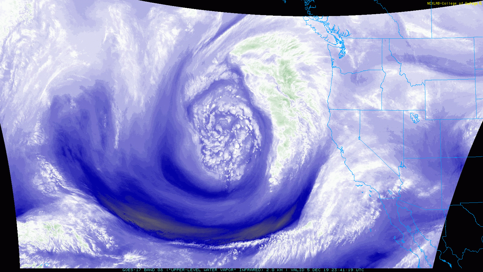
There are no major changes to the forecast. Coastal and inland areas should get 2-3" of total rainfall (map below). Areas in the mountains will exceed 4-5" of precipitation (rain/snow combined). Local mountains will get several inches of snow (map below). Taller mountains to the north will get as much as 2 feet. Rain will exit the region Friday night.

As always, visit the National Weather Service for all the latest weather advisories and warnings in our area. Stay safe!

https://www.weather.gov/sgx/


Wednesday Afternoon
Showers will approach from the north around noon today. This rainfall will persist into the early evening. Winds 15-25, up to 40 in the mountains. Snow levels 6,000-7,000.

Wednesday Night
Intermittent showers. Winds 5-15, up to 30 in the mountains. Snow levels 5,000 to 6,000 feet.

Thursday Morning
Rain with embedded downpours and isolated thunderstorms will overspread the area starting at 5-6 AM. Winds 25-35, gusts up to 55 in the mountains. Snow levels 5,000 to 6,000 feet.

Thursday Afternoon
Rain with isolated downpours/thunderstorms move through the area. Showers will become more intermittent by the evening. Winds 15-25, gusts up to 50 in the mountains. Snow levels 4,500 to 5,500 feet.

Thursday Night
Periods of rain, occasional downpour possible. Winds 15-25, gusts up to 50 in the mountains. Snow levels 3,500 to 4,500 feet.

Friday Morning 
Lingering showers. Winds 10-20, gusts up to 45 in the mountains. Snow levels 3,000 to 4,000 feet.

Friday Afternoon
Isolated showers.  Winds 15-25, gusts up to 50 in the mountains. Snow levels 3,500 to 4,500 feet.

Friday Night 
Rain chance diminishes.  Winds 5-15, gusts up to 40 in the mountains. Snow levels 3,500 to 4,500 feet.

Computer projected rain totals from this storm system

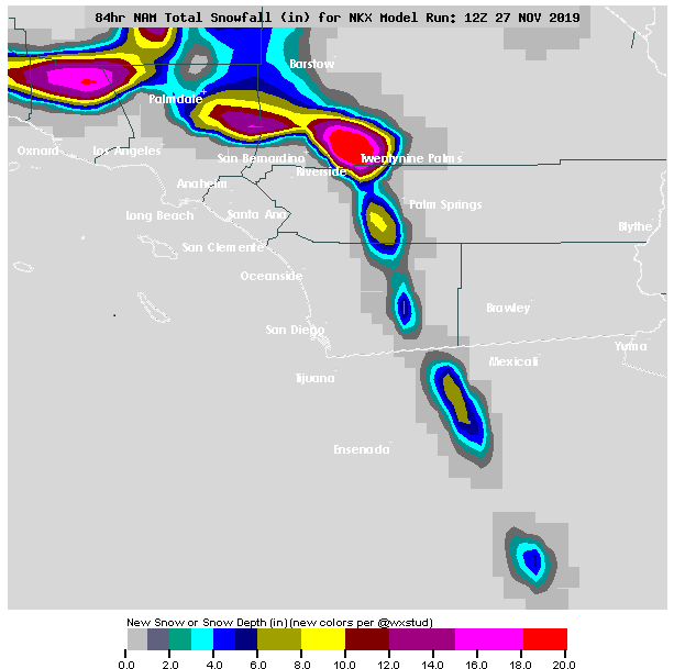
Computer projected snow totals from this storm system

NEXT RAIN CHANCE SAN DIEGO: UPDATED SUNDAY 11-24-2019

I've sifted through all the latest data this morning. A forecast like this is always challenging because the slightest shift in storm track can dramatically affect rain and snow totals. Computer forecasts have been a little inconsistent with the track of the core of this system. There has been some wobbling east and west, though this is to be expected. Regardless, not much has changed with the forecast - rain is likely for the upcoming week with significant snow in the mountains.

Showers could start as early as late morning Wednesday (40%), then rain is likely Wednesday afternoon/evening (100%). Periods of rain with embedded heavy downpours will then persist on-and-off through the day Thanksgiving (100%). It will be a raw and windy day. Wind gusts in the mountains will be intense.

Intermittent showers will linger on Friday (80%). The rain chance then diminishes Friday night.

Snow levels will start at 7,000 feet Wednesday morning, then steadily drop through the day to 5,000 feet Wednesday night. Snow levels will range from 4,000 to 5,000 Thursday, then fall as low as 3,000 feet on Friday. The tallest mountains in San Diego County could easily get a few inches. Peaks in the San Jacinto and San Bernardino mountains should exceed a foot of snow.

I've included the latest computer forecast for rain and snow totals. This system is still far away, so there will be some adjustments to this forecast in the coming days.


NEXT RAIN CHANCE SAN DIEGO: UPDATED FRIDAY 11-22-2019

I'm keeping a close eye on our next storm system, which could bring significant rainfall to Southern California heading into Thanksgiving. There will be an enormous buckle in the jet stream, which will allow a powerful storm system to dive south from the Gulf of Alaska and settle right off the coast of California. You can spot it on the first map below.

Most computer forecasts have rain arriving in our area midday Wednesday. We will then experience several rounds of rain with embedded downpours that will persist through the day on Thanksgiving.

Intermittent showers and isolated thunderstorms will be possible on Friday, then lingering showers will diminish Saturday. If this system takes the current projected path, rain totals could easily approach 3-4" with higher amounts in the mountains. I've included one computer outlook below.

Snow levels will be high though Thanksgiving, then levels will drop as the core of the system passes overhead. This should bring snow to the taller mountains in San Diego County.

This storm system is still far away, so a lot can change with the forecast. Given the upcoming Holiday, you should start planning for bad road conditions. Better safe than sorry!

I'll bring more updates in the coming days.


SNOW TOTALS SOUTHERN CALIFORNIA: TUESDAY 11-19-2019 TO THURSDAY 11-21-2019

STATION                        SNOW(IN)   ELEVATION(FT)

GREEN VALLEY LAKE                 13           6900
ARROWBEAR                          9           6200
RUNNING SPRINGS                    9           6200
BIG BEAR RESORTS                   5           7100
END OF BALDY ROAD                  5           6400
BARTON FLATS                       4           8800
WRIGHTWOOD                         4           6040
LAKE ARROWHEAD                     3           5400
FOREST FALLS                       3           6000
BLUE JAY                           3           5400
BIG BEAR LAKE                      3           6800
WRIGHTWOOD                         3           5900
BIG BEAR CITY                      3           6800
RUNNING SPRINGS                    2-3         6100
PALOMAR MTN                        2           5580
ANGELUS OAKS                       2           5700
BIRCH HILL                         2           5645
MT. LAGUNA LODGE                   2           5918
CRESTLINE                          1.5         4500
LAKE ARROWHEAD                     1.5         5200

SAN DIEGO RAIN TOTALS: TUESDAY 11-19-2019 TO THURSDAY 11-21-2019

Here are the 3-day rain totals at 5 PM Thursday.


Barona (BNAC1)2.79
Barret Lake (BRTC1)3.07
Birch Hill (IRCC1)4.42
Bonita (BNNC1)1.52
Bonsall (BOSC1)1.35
Brown Field (SDM)2.08
Cactus County Park (CCPC1)1.76
Camp Pendleton (NFG)1.09
Cuyamaca Reservoir (CYDC1)4.35
Deer Springs (DRGC1)2.74
Descanso (DENC1)4.43
Echo Dell (ECDC1)3.59
El Cajon (LCKC1)2.19
El Camino Del Norte (ECMC1)1.21
El Capitan Dam (ELPC1)2.36
Encinitas (ENCC1)0.87
Escondido (ESOC1)2.40
Fashion Valley (FSNC1)0.99
Flinn Springs (FLYC1)2.61
Goose Valley (GOSC1)3.05
Granite Hills (GRHC1)2.13
Harbison Canyon (HARC1)2.80
Henshaw Dam (HAWC1)4.69
Julian (JLNC1)3.28
Kearny Mesa (KEAC1)0.83
La Jolla Amago (LJOC1)3.20
La Mesa (LMSC1)1.30
Lake Hodges (HODC1)2.89
Las Flores (LSFC1)0.24
Lindbergh Int'l Airport (SAN)0.78
Marron Valley (MAVC1)1.10
Mesa Grande (MEGC1)3.91
Miramar Lake (MMRC1)1.84
Mission Valley (BVDC1)1.20
Mt Woodson Rd - Ramona (RMAC1)2.89
Oceanside (OCNC1)0.67
Oceanside (OKB)0.87
Otay Mountain (OTYC1)4.52
Palomar Airport (CRQ)1.03
Palomar Airport (PLMC1)1.05
Palomar Mountain CRS (PMMC1)4.31
Pine Hills (PIHC1)3.84
Pine Hills Fire Station (PHIC1)4.21
Point Loma (L13)1.11
Potrero (PRCC1)3.45
Poway (PWYC1)2.47
Ramona (RMNC1)3.70
Ramona (RNM)2.15
Rancho Bernardo (RNBC1)2.12
Rincon Springs (RINC1)3.04
Roads Division 1 HQ (RDHC1)1.97
San Diego Estates (ESTC1)2.02
San Marcos Cnty Rd Stn (SMXC1)1.52
San Marcos Landfill (NMLC1)1.21
San Miguel (MIGC1)0.91
San Pasqual (PSQC1)2.58
Santa Ysabel (SYSC1)3.40
Santee - Mast Rd (STEC1)0.24
Skyline Ranch (SKLC1)3.19
Solana Beach (SOB)0.13
Sutherland Dam (SUDC1)4.11
Vallecitos Repeater (VCIC1)2.35
Valley Center (VALC1)4.33
Valley Center (VLCC1)4.14
Volcano Mountain (VCNC1)3.67
Warner Springs (WSGC1)3.18
Wire Mountain (WIRC1)0.70
Witch Creek Fire Stn (WCHC1)3.79
Wohlford Dam (WHLC1)2.18

NEXT RAIN CHANCE SAN DIEGO: UPDATED MONDAY 11-18-2019

There are no major changes from the initial forecast. The storm system is on our doorstep and will bring the first substantial rainfall to Southern California this rain season.

On the satellite image below, you can spot a system spinning to our south. This will provide some moisture to our area tomorrow. An isolated shower could pop up Tuesday, especially in the afternoon (40%).

A better chance for rain arrives Tuesday night and persists through the day on Wednesday as a more potent system dives from the north (also spotted on the satellite image below). Periods of rain are likely during this time period (90%). Isolated downpours and thunderstorms are also possible.

Lingering showers are possible Thursday, especially in the morning, as the system exits the region (60%). The rain chance completely diminishes by late Thursday afternoon.

Rain totals will range from 0.5" to 1.0" for coastal and inland areas. Isolated areas in the mountains could easily exceed 2.0". I've posted a computer forecast of rain totals below.

Snow levels will drop as low as 5,500 feet on Wednesday. Some wet snow is possible on the tallest mountains in San Diego County, though it probably won't accumulate. Taller mountains to the north (above 8,000 feet) will get a few inches of wet snow.

Stay safe out there!


NEXT RAIN CHANCE SAN DIEGO: UPDATED THURSDAY 11-14-2019

Computer forecasts continue to show a storm system diving out of the Gulf of Alaska and bringing rain to Southern California next week. I was a tad skeptical of this scenario. It's a challenging forecast, especially given our current weather pattern (dry and warm). Regardless, the computers are persistent, so it can't be neglected.

Given the current data, isolated showers will develop next Tuesday night (20%), then the best chance for rain will arrive Wednesday (40%). Isolated thunderstorms will also be possible. Lingering showers will exit the region Thursday afternoon (30%).

We are in a turbulent weather pattern, so I am certain that there will be some adjustments on the timing of this system. I'll keep watching it and bring more updates in the coming days.


NEXT RAIN CHANCE SAN DIEGO: UPDATED THURSDAY 10-24-2019

During this time of the year, all eyes are up near the Gulf of Alaska and out in the Pacific. These are where almost all of our storm systems originate. I've been closely watching a system brewing up near Alaska (seen on the satellite loop below). This will bring us a brief chance for rain Sunday night.

Latest computer forecasts have this system clipping our area Sunday evening into Sunday night. The storm track isn't ideal, in fact, most energy will be focused east of our area. Also, moisture will be limited. Regardless, it's a potent system that will bring winds and a slight chance for rain, or even a brief thunderstorm (30% chance for rain). Afterwards, the rest of next workweek looks dry and warm.

I'll keep watching it and bring more updates if there are any changes to the forecast.


SAN DIEGO RAIN TOTALS: SATURDAY 9-28-2019


Alpine (ANEC1)0.03
Barona (BNAC1)0.05
Barret Lake (BRTC1)0.00
Barrett Junction (BAJC1)0.00
Birch Hill (IRCC1)0.22
Bonita (BNNC1)0.01
Bonsall (BOSC1)0.00
Brown Field (SDM)0.00
Cactus County Park (CCPC1)0.11
Camp Pendleton (NFG)0.00
Cuyamaca Reservoir (CYDC1)0.03
Deer Springs (DRGC1)0.09
Descanso (DENC1)0.04
Descanso RS (DSCC1)0.00
Dulzura Summit (DULC1)0.00
Eastern Tanks (ETKC1)0.28
Echo Dell (ECDC1)0.02
El Cajon (LCKC1)0.07
El Camino Del Norte (ECMC1)0.06
El Capitan Dam (ELPC1)0.25
Encinitas (ENCC1)0.04
Escondido (ESOC1)0.10
Fashion Valley (FSNC1)0.01
Flinn Springs (FLYC1)0.24
Goose Valley (GOSC1)0.06
Granite Hills (GRHC1)0.06
Harbison Canyon (HARC1)0.10
Henshaw Dam (HAWC1)0.07
Julian (JLNC1)0.13
Julian (JULC1)0.11
Kearny Mesa (KEAC1)0.03
La Jolla Amago (LJOC1)0.20
La Mesa (LMSC1)0.11
Lake Hodges (HODC1)0.03
Lake Murray (MUYC1)0.20
Las Flores (LSFC1)0.00
Lindbergh Int'l Airport (SAN)0.01
Marron Valley (MAVC1)0.00
Mesa Grande (MEGC1)0.10
Miramar Lake (MMRC1)0.15
Miramar Marine Corps Stn (NKX)0.04
Mission Valley (BVDC1)0.02
Montgomery Field (MYF)0.01
Mt Woodson Rd - Ramona (RMAC1)0.15
North Island NAS (NZY)0.00
Oceanside (OCNC1)0.01
Oceanside (OKB)0.02
Otay Mountain (OTYC1)0.04
Palomar Airport (CRQ)0.04
Palomar Airport (PLMC1)0.03
Palomar Mountain CRS (PMMC1)0.45
Pine Hills (PIHC1)0.12
Pine Hills Fire Station (PHIC1)0.11
Point Loma (L13)0.00
Potrero (PRCC1)0.00
Potrero CDF (POTC1)0.00
Poway (PWYC1)0.06
Ramona (RMNC1)0.15
Ramona (RNM)0.06
Rancho Bernardo (RNBC1)0.03
Red Gate Repeater (RGPC1)0.31
Rincon Springs (RINC1)0.21
Roads Division 1 HQ (RDHC1)0.02
San Diego Estates (ESTC1)0.08
San Marcos Cnty Rd Stn (SMXC1)0.04
San Marcos Landfill (NMLC1)0.13
San Miguel (MIGC1)0.01
San Pasqual (PSQC1)0.06
San Ysidro (YSDC1)0.00
Santa Ysabel (SYSC1)0.05
Santee - Mast Rd (STEC1)0.01
Skyline Ranch (SKLC1)0.18
Solana Beach (SOB)0.04
Sutherland Dam (SUDC1)0.17
Tijuana R - Int'l Bndry (TIJC1)0.00
Vallecitos Repeater (VCIC1)0.28
Valley Center (VALC1)0.19
Valley Center (VLCC1)0.25
Volcano Mountain (VCNC1)0.07
Warner Springs (WSGC1)0.03
Wire Mountain (WIRC1)0.00
Witch Creek Fire Stn (WCHC1)0.09
Wohlford Dam (WHLC1)0.25

NEXT RAIN CHANCE SAN DIEGO: UPDATED MONDAY 9-23-2019

It's been awhile since I've updated this blog. Rain season has returned!

A small storm system is settling into the SW United States. You can spot it on the satellite image below. Most computer forecasts have this system drifting around our area for the next few days.

It will be close enough to Southern California to bring a chance for a few showers and isolated downpours on Wednesday and Thursday. The atmosphere will be unstable enough to support thunderstorms as well.

The rain chance diminishes by Friday. We have a cold front headed this way for Sunday into the start of the next workweek. This will bring in more fall-like weather.


SAN DIEGO RAIN TOTALS: THURSDAY 9-5-2019


Volcano Mountain (VCNC1)0.44
Keenwild (KNWC1)0.33
Mount Laguna (LGMC1)0.30
Mount Laguna (MLGC1)0.19
Mount San Jacinto (MSJC1)0.13
Ranchita (RTAC1)0.06
Julian (JULC1)0.06
Mountain Springs Grade (TNSC1)0.04
Warner Springs (WSGC1)0.02
Anza (NZAC1)0.02
Ranchita CDF (RCHC1)0.01
Pine Valley County Park (PNVC1)0.01

SAN DIEGO RAIN TOTALS: WEDNESDAY 9-4-2019


Alpine (ANEC1)0.23
Barona (BNAC1)0.01
Barret Lake (BRTC1)0.24
Barrett Junction (BAJC1)0.07
Birch Hill (IRCC1)0.00
Bonita (BNNC1)0.15
Bonsall (BOSC1)0.00
Brown Field (SDM)0.14
Cuyamaca Reservoir (CYDC1)0.00
Deer Springs (DRGC1)0.00
Descanso (DENC1)0.36
Dulzura Summit (DULC1)0.00
Eastern Tanks (ETKC1)0.03
El Cajon (LCKC1)0.38
El Camino Del Norte (ECMC1)0.00
El Capitan Dam (ELPC1)0.00
Encinitas (ENCC1)0.00
Escondido (ESOC1)0.33
Fashion Valley (FSNC1)0.00
Goose Valley (GOSC1)0.00
Granite Hills (GRHC1)0.18
Harbison Canyon (HARC1)0.20
Henshaw Dam (HAWC1)0.01
Julian (JLNC1)0.00
Julian (JULC1)0.00
Kearny Mesa (KEAC1)0.02
La Jolla Amago (LJOC1)0.08
La Mesa (LMSC1)0.11
Lake Murray (MUYC1)0.11
Las Flores (LSFC1)0.00
Lindbergh Int'l Airport (SAN)0.01
Mesa Grande (MEGC1)0.00
Miramar Lake (MMRC1)0.01
Mission Valley (BVDC1)0.06
Montgomery Field (MYF)0.01
North Island NAS (NZY)0.00
Oceanside (OCNC1)0.00
Oceanside (OKB)0.00
Otay Mountain (OTYC1)0.00
Palomar Airport (CRQ)0.00
Palomar Airport (PLMC1)0.00
Palomar Mountain CRS (PMMC1)0.02
Pine Hills (PIHC1)0.00
Pine Hills Fire Station (PHIC1)0.00
Point Loma (L13)0.00
Potrero (PRCC1)0.11
Potrero CDF (POTC1)0.01
Poway (PWYC1)0.00
Ramona (RMNC1)0.00
Ramona (RNM)0.00
Rancho Bernardo (RNBC1)0.09
Red Gate Repeater (RGPC1)0.00
Rincon Springs (RINC1)0.00
Roads Division 1 HQ (RDHC1)0.07
San Diego Estates (ESTC1)0.00
San Marcos Cnty Rd Stn (SMXC1)0.00
San Marcos Landfill (NMLC1)0.00
San Miguel (MIGC1)0.01
San Pasqual (PSQC1)0.00
San Ysidro (YSDC1)0.00
Santa Ysabel (SYSC1)0.00
Santee - Mast Rd (STEC1)0.01
Skyline Ranch (SKLC1)0.00
Smugglers Gulch (UGGC1)0.00
Solana Beach (SOB)0.00
Tijuana R - Int'l Bndry (TIJC1)0.00
Vallecitos Repeater (VCIC1)0.07
Valley Center (VALC1)0.00
Valley Center (VLCC1)0.00
Volcano Mountain (VCNC1)0.00
Warner Springs (WSGC1)0.00
Wire Mountain (WIRC1)0.00
Wohlford Dam (WHLC1)0.00

SAN DIEGO RAIN TOTALS: FRIDAY 6-21-2019


Alpine (ANEC1)0.00
Barona (BNAC1)0.00
Barret Lake (BRTC1)0.00
Barrett Junction (BAJC1)0.00
Birch Hill (IRCC1)0.00
Bonita (BNNC1)0.03
Bonsall (BOSC1)0.00
Brown Field (SDM)0.03
Cactus County Park (CCPC1)0.00
Camp Pendleton (NFG)0.09
Cuyamaca Reservoir (CYDC1)0.00
Deer Springs (DRGC1)0.01
Descanso (DENC1)0.00
Descanso RS (DSCC1)0.00
Dulzura Summit (DULC1)0.00
Eastern Tanks (ETKC1)0.00
Echo Dell (ECDC1)0.00
El Cajon (LCKC1)0.00
El Camino Del Norte (ECMC1)0.01
El Capitan Dam (ELPC1)0.00
Encinitas (ENCC1)0.09
Escondido (ESOC1)0.01
Fashion Valley (FSNC1)0.02
Flinn Springs (FLYC1)0.00
Goose Valley (GOSC1)0.00
Granite Hills (GRHC1)0.00
Harbison Canyon (HARC1)0.00
Henshaw Dam (HAWC1)0.00
Julian (JLNC1)0.00
Julian (JULC1)0.01
Kearny Mesa (KEAC1)0.08
La Jolla Amago (LJOC1)0.00
La Mesa (LMSC1)0.03
Lake Hodges (HODC1)0.01
Lake Murray (MUYC1)0.00
Las Flores (LSFC1)0.09
Marron Valley (MAVC1)0.00
Mesa Grande (MEGC1)0.02
Miramar Lake (MMRC1)0.06
Miramar Marine Corps Stn (NKX)0.07
Mission Valley (BVDC1)0.07
Montgomery Field (MYF)0.08
Mt Woodson Rd - Ramona (RMAC1)0.00
North Island NAS (NZY)0.03
Oceanside (OCNC1)0.08
Oceanside (OKB)0.05
Otay Mountain (OTYC1)0.01
Palomar Airport (CRQ)0.06
Palomar Airport (PLMC1)0.05
Palomar Mountain CRS (PMMC1)0.00
Pine Hills (PIHC1)0.00
Pine Hills Fire Station (PHIC1)0.00
Potrero (PRCC1)0.00
Potrero CDF (POTC1)0.00
Poway (PWYC1)0.01
Ramona (RMNC1)0.00
Ramona (RNM)0.00
Rancho Bernardo (RNBC1)0.00
Red Gate Repeater (RGPC1)0.00
Rincon Springs (RINC1)0.00
Roads Division 1 HQ (RDHC1)0.00
San Diego Estates (ESTC1)0.00
San Marcos Cnty Rd Stn (SMXC1)0.01
San Marcos Landfill (NMLC1)0.03
San Miguel (MIGC1)0.04
San Pasqual (PSQC1)0.01
San Ysidro (YSDC1)0.00
Santa Ysabel (SYSC1)0.02
Santee - Mast Rd (STEC1)0.02
Skyline Ranch (SKLC1)0.01
Solana Beach (SOB)0.06
Sutherland Dam (SUDC1)0.01
Tijuana R - Int'l Bndry (TIJC1)0.01
Vallecitos Repeater (VCIC1)0.00
Valley Center (VALC1)0.02
Valley Center (VLCC1)0.01
Volcano Mountain (VCNC1)0.02
Warner Springs (WSGC1)0.00
Wire Mountain (WIRC1)0.10
Witch Creek Fire Stn (WCHC1)0.01
Wohlford Dam (WHLC1)0.04

SAN DIEGO RAIN TOTALS: SUNDAY 5-26-2019 TO MONDAY 5-27-2019


Alpine (ANEC1)0.36
Barona (BNAC1)0.18
Barret Lake (BRTC1)0.26
Barrett Junction (BAJC1)0.35
Birch Hill (IRCC1)0.79
Bonita (BNNC1)0.08
Bonsall (BOSC1)0.08
Brown Field (SDM)0.14
Cactus County Park (CCPC1)0.18
Camp Pendleton (NFG)0.06
Cuyamaca Reservoir (CYDC1)0.88
Deer Springs (DRGC1)0.09
Descanso (DENC1)0.48
Descanso RS (DSCC1)0.65
Dulzura Summit (DULC1)0.23
Eastern Tanks (ETKC1)0.63
Echo Dell (ECDC1)0.42
El Cajon (LCKC1)0.16
El Camino Del Norte (ECMC1)0.08
El Capitan Dam (ELPC1)0.28
Encinitas (ENCC1)0.04
Escondido (ESOC1)0.12
Flinn Springs (FLYC1)0.25
Goose Valley (GOSC1)0.00
Granite Hills (GRHC1)0.18
Harbison Canyon (HARC1)0.26
Henshaw Dam (HAWC1)0.43
Julian (JLNC1)0.70
Julian (JULC1)0.64
Kearny Mesa (KEAC1)0.16
La Jolla Amago (LJOC1)0.58
La Mesa (LMSC1)0.06
Lake Hodges (HODC1)0.18
Lake Murray (MUYC1)0.04
Las Flores (LSFC1)0.00
Lindbergh Int'l Airport (SAN)0.05
Marron Valley (MAVC1)0.16
Mesa Grande (MEGC1)0.66
Miramar Lake (MMRC1)0.12
Mission Valley (BVDC1)0.09
Missle (MSXC1)0.00
Montgomery Field (MYF)0.14
Mt Woodson Rd - Ramona (RMAC1)0.45
North Island NAS (NZY)0.02
Oceanside (OCNC1)0.02
Otay Mountain (OTYC1)0.40
Palomar Airport (CRQ)0.09
Palomar Airport (PLMC1)0.09
Palomar Mountain CRS (PMMC1)0.95
Pine Hills (PIHC1)0.86
Pine Hills Fire Station (PHIC1)0.90
Potrero (PRCC1)0.36
Poway (PWYC1)0.17
Ramona (RMNC1)0.29
Ramona (RNM)0.21
Rancho Bernardo (RNBC1)0.09
Red Gate Repeater (RGPC1)0.38
Rincon Springs (RINC1)0.22
Roads Division 1 HQ (RDHC1)0.15
San Diego Estates (ESTC1)0.23
San Marcos Cnty Rd Stn (SMXC1)0.08
San Marcos Landfill (NMLC1)0.09
San Miguel (MIGC1)0.10
San Pasqual (PSQC1)0.21
Santa Ysabel (SYSC1)0.49
Santee - Mast Rd (STEC1)0.00
Skyline Ranch (SKLC1)0.37
Solana Beach (SOB)0.04
Sutherland Dam (SUDC1)0.73
Tijuana Estuary (TJEC1)0.08
Vallecitos Repeater (VCIC1)0.50
Valley Center (VALC1)0.20
Valley Center (VLCC1)0.15
Volcano Mountain (VCNC1)0.83
Warner Springs (WSGC1)0.22
Wire Mountain (WIRC1)0.06
Witch Creek Fire Stn (WCHC1)0.54
Wohlford Dam (WHLC1)0.28

FORECAST

HOURLY TEMPERATURE FORECAST

COAST INLAND

BLOG ARCHIVE