ADVERTISEMENT

Early February Outlook For San Diego & Southern California

We are going to see a blocking pattern develop in the jet stream for the first half of February. This will deflect storm systems away from the West Coast. In other words, San Diego and most of California will stay dry and mild.

You can spot the Omega-shaped ridge on the first map below. The second map shows this pattern eroding by Friday, February 10, but I remain skeptical. Once a pattern like this develops, it takes a long time for it to break down. Regardless, we could see rain return by mid to late February.

Lastly, with such a calm pattern, foggy nights/mornings will return to the coast.


Extended Outlook For Southern California - Thursday, 1/26 to Wednesday, 2/8

Summary
Southern California is headed towards an extended period of dry and mild weather. We could see some clouds and a few sprinkles next Tuesday into Wednesday, otherwise, we should stay dry through the first week of February. The average high temperature is 66 for San Diego in late January. I'm expecting our highs to remain near or above this for the next two weeks. In addition, several days will have highs climbing into the mid and upper 70s.

Technical
Things are looking pretty grim this rain season. You can see on the map below that most of the state is well below normal for rainfall this season.


Temperatures have been cooler than normal along the coast for most of rain season, but it has been very warm inland.


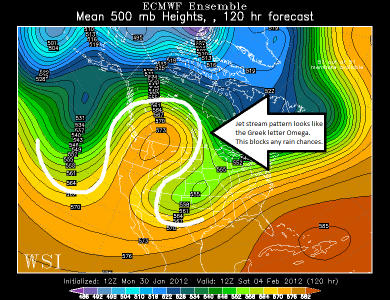
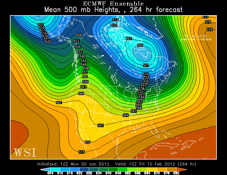
The upper-level weather pattern might become more favorable for rain by the middle of February, unless we get stuck in a blocking pattern. I have embedded my analysis in the maps below (click to enlarge).


Update On Possible Mid-Atlantic Snow

As expected, the ECMWF has shifted the snow off the coast on Sunday. It will probably flip-flop over the next couple days, so it is still worth watching.


First Real Snow For Mid-Atlantic?

This is only one run of the ECMWF, and it is still very far away (things will change), but...

This looks extremely interesting for next Sunday:


Rain Outlook For California Today Through Saturday 1/21

Wow, and this is only the beginning for Northern California! San Diego and most of Southern California will see a few showers Saturday, but it won't amount to much.


Late January Outlook: Southern California, Pacific Northwest, East Coast

Summary
  • Southern California - After an extended period of warm and dry weather, the second half of January will feature some cooler weather mixed with seasonably mild conditions. An occasional chance for a shower will pop up, but it will remain drier than average.
  • Northern California - Finally some rain! This is great news for everyone in NorCal and the Pacific Northwest. There will be a parade of storm systems bringing periods of heavy rain for the last half of this month.
  • East Coast - Mild weather will continue with a few chances for rain, which is always good news. However, it's bad news for snow lovers. Things could briefly change for early February, but don't hold your breath!
My technical discussion is embedded within the maps below (ECMWF ensemble 500 mb heights/anomalies). Be sure to click the images to enlarge so that you can read the text. Enjoy!


Mid January Outlook for Southern California

I recently sent out a Twitter update about this - the weather pattern is about to shift. The impacts will be minimal in Southern California, though the record-breaking heat will not return for the rest of the month. Instead, San Diego and surrounding areas will remain dry and seasonably mild through at least January 25.

However, the Pacific Northwest and Eastern U.S. will see some big changes. A persistent ridge (highlighted below) has been the dominant feature over the past three weeks for San Diego and all of California. This has kept the entire state hot and extremely dry.

FORECAST

HOURLY TEMPERATURE FORECAST

COAST INLAND

BLOG ARCHIVE