ADVERTISEMENT

SAN DIEGO RAIN TOTALS: MONDAY 3-28-2022

Rain totals ranged from 0.5" to 1.5" with isolated areas receiving near 2.0".

Agua Caliente (AGUC1)0.21
Alpine (ANEC1)1.18
Barona (BNAC1)0.96
Barret Lake (BRTC1)1.41
Barrett Junction (BAJC1)1.63
Birch Hill (IRCC1)1.51
Bonita (BNNC1)1.86
Bonsall (BOSC1)0.92
Borrego Palm Canyon (BRPC1)0.05
Borrego Springs (BGOC1)0.01
Brown Field (SDM)1.85
Cactus County Park (CCPC1)0.58
Cameron Guard Station (CMNC1)1.13
Camp Elliot (MPEC1)0.73
Campo (CMFC1)1.24
Case Springs (CSPC1)1.12
CMP Target Range (CTGC1)1.07
Core Grade Road (OLEC1)0.72
Couser Canyon (OUSC1)0.76
Coyote Cyn Creek (CCYC1)0.05
Cuyamaca Reservoir (CYDC1)2.67
Deer Springs (DRGC1)1.27
Descanso (DENC1)1.57
Descanso RS (DSCC1)1.71
Dulzura Summit (DULC1)1.02
Eastern Tanks (ETKC1)0.95
Echo Dell (ECDC1)1.51
El Cajon (LCKC1)0.61
El Camino Del Norte (ECMC1)0.71
El Capitan Dam (ELPC1)1.10
Encinitas (ENCC1)0.60
Fallbrook (FBZC1)1.44
Fallbrook (FLBC1)0.76
Fashion Valley (FSNC1)0.80
Flinn Springs (FLYC1)1.09
Goose Valley (GOSC1)0.95
Granite Hills (GRHC1)0.98
Harbison Canyon (HARC1)1.43
Henshaw Dam (HAWC1)1.55
Japatul Fire Station (JFSC1)1.76
Julian (JULC1)1.48
Kearny Mesa (KEAC1)0.73
La Jolla Amago (LJOC1)0.89
La Mesa (LMSC1)0.44
Lake Hodges (HODC1)0.70
Lake Morena (MRAC1)1.26
Las Flores (LSFC1)0.69
Lindbergh Int'l Airport (SAN)0.69
Loma Tova (LMTB1)0.04
Lower Oat Flats (OFLC1)1.66
Miramar Lake (MMRC1)0.71
Mission Valley (BVDC1)0.71
Missle (MSXC1)1.07
Montgomery Field (MYF)0.71
Mount Laguna (LGMC1)0.72
Mount Laguna (MLGC1)0.76
Mt Woodson Rd - Ramona (RMAC1)1.51
Oak Grove (OGVC1)0.56
Oceanside (OCNC1)0.46
Pala 2W (PZAC1)0.88
Palomar Airport (CRQ)0.93
Palomar Airport (PLMC1)0.95
Palomar Mountain (PRMC1)1.88
Palomar Mountain CRS (PMMC1)1.68
Pine Hills (PIHC1)1.71
Pine Hills Fire Station (PHIC1)1.76
Pine Valley County Park (PNVC1)1.35
Point Loma (L13)0.58
Potrero (PRCC1)1.21
Potrero CDF (POTC1)1.06
Poway (PWYC1)0.73
Rainbow Camp (RAIC1)1.12
Rainbow County Park (RABC1)0.87
Ramona (RMNC1)0.84
Ramona (RNM)0.98
Ranchita (RTAC1)0.32
Ranchita CDF (RCHC1)0.30
Ranchita Margarita (RMGC1)1.68
Rancho Bernardo (RNBC1)0.70
Red Gate Repeater (RGPC1)0.71
Rincon Springs (RINC1)0.74
Roads Division 1 HQ (RDHC1)1.35
San Diego Estates (ESTC1)1.10
San Marcos Cnty Rd Station (SMXC1)0.68
San Marcos Landfill (NMLC1)0.76
San Miguel (MIGC1)2.02
San Pasqual (PSQC1)0.70
San Ysidro (YSDC1)1.57
Santa Rosa Plateau (SRUC1)1.13
Santa Ysabel (SYSC1)1.09
Santee - Mast Rd (STEC1)0.72
Skyline Ranch (SKLC1)1.06
Smugglers Gulch (UGGC1)1.93
Sutherland Dam (SUDC1)1.03
Talega (TLGC1)0.57
Temecula (TEMC1)0.79
Thousand Trails - Jamul (TTRC1)2.11
Tierra Del Sol (TRRC1)0.68
Tijuana Estuary (TJEC1)1.69
Valley Center (VALC1)1.11
Volcano Mountain (VCNC1)1.05
Warner Springs (WSGC1)0.71
Wire Mountain (WIRC1)0.65
Witch Creek Fire Station (WCHC1)1.06
Wohlford Dam (WHLC1)1.10


NEXT RAIN CHANCE SAN DIEGO: UPDATED THURSDAY 3-24-2022

*Updated at 9 AM Monday to change timing of rainfall*

Computer projections have been very consistent over the past couple days, so I can confidently say that some much needed rainfall will return to our area next Monday into early Tuesday. 

It's looking like this will come in two waves. The first round of rainfall will arrive around 11 AM Monday, where showers and isolated thunderstorms are possible. This round will exit around 5 PM.

The second wave will arrive Monday evening and Monday night, when the core of the system passes overhead. There is a better chance for thunderstorms during this time. These can bring downpours, wind and possibly hail.

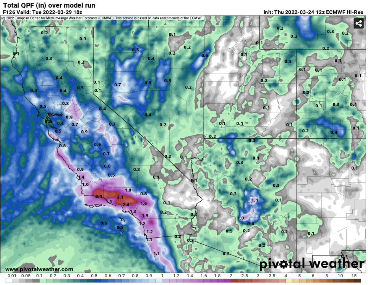
Rain totals will range from 0.5 to 1.5" across the area, with isolated areas getting 2.0"

Snow levels will stay fairly high with this system, so local mountains might see some snow, but no accumulations. However, the highest peaks in the San Bernardino and San Gabriel Mountains will receive several inches of snow.

Most of the precipitation will exit by early Tuesday morning. I'll keep an eye on this storm and bring updates if needed.

Computer projected rain totals through next Tuesday morning
 
Computer projected rain totals through next Tuesday morning

Computer projected snow totals through next Tuesday morning

SAN DIEGO RAIN TOTALS: SUNDAY 3-20-2022

Agua Caliente (AGUC1)0.00
Alpine (ANEC1)0.25
Barona (BNAC1)0.16
Barret Lake (BRTC1)0.30
Barrett Junction (BAJC1)0.38
Birch Hill (IRCC1)0.51
Bonita (BNNC1)0.20
Bonsall (BOSC1)0.18
Borrego Palm Canyon (BRPC1)0.00
Borrego Springs (BGOC1)0.00
Brown Field (SDM)0.26
Cactus County Park (CCPC1)0.32
Cameron Guard Station (CMNC1)0.24
Camp Elliot (MPEC1)0.36
Campo (CMFC1)0.13
Case Springs (CSPC1)0.22
CMP Target Range (CTGC1)0.21
Core Grade Road (OLEC1)0.44
Couser Canyon (OUSC1)0.22
Coyote Cyn Creek (CCYC1)0.01
Cuyamaca Reservoir (CYDC1)0.45
Deer Springs (DRGC1)0.30
Descanso (DENC1)0.31
Descanso RS (DSCC1)0.35
Dulzura Summit (DULC1)0.25
Eastern Tanks (ETKC1)0.55
Echo Dell (ECDC1)0.38
El Cajon (LCKC1)0.23
El Camino Del Norte (ECMC1)0.18
El Capitan Dam (ELPC1)0.60
Encinitas (ENCC1)0.17
Fallbrook 5NE (FBOC1)0.05
Fallbrook (FBZC1)0.20
Fallbrook (FLBC1)0.15
Fallbrook Community AP (L18)0.15
Fashion Valley (FSNC1)0.24
Flinn Springs (FLYC1)0.35
Goat Canyon (GOCC1)0.20
Goose Valley (GOSC1)0.21
Granite Hills (GRHC1)0.22
Harbison Canyon (HARC1)0.29
Henshaw Dam (HAWC1)0.12
Japatul Fire Station (JFSC1)0.26
Julian (JULC1)0.31
Kearny Mesa (KEAC1)0.34
La Jolla Amago (LJOC1)0.61
La Mesa (LMSC1)0.29
Lake Hodges (HODC1)0.18
Lake Morena (MRAC1)0.16
Lake Murray (MUYC1)0.19
Las Flores (LSFC1)0.18
Lindbergh Int'l Airport (SAN)0.29
Loma Tova (LMTB1)0.00
Lower Oat Flats (OFLC1)0.31
Marron Valley (MAVC1)0.20
Mesa Grande (MEGC1)0.34
Miramar Lake (MMRC1)0.34
Mission Valley (BVDC1)0.25
Missle (MSXC1)0.28
Montgomery Field (MYF)0.26
Mount Laguna (LGMC1)0.18
Mount Laguna (MLGC1)0.19
Mt Woodson Rd - Ramona (RMAC1)0.37
Oak Grove (OGVC1)0.17
Oceanside (OCNC1)0.44
Oceanside (OKB)0.40
Otay Mountain (OTYC1)0.48
Pala 2W (PZAC1)0.19
Palomar Airport (CRQ)0.19
Palomar Airport (PLMC1)0.21
Palomar Mountain (PRMC1)0.43
Palomar Mountain CRS (PMMC1)0.59
Palomar Mountain USFS (PAMC1)0.40
Pine Hills (PIHC1)0.41
Pine Hills Fire Station (PHIC1)0.41
Pine Valley County Park (PNVC1)0.27
Point Loma (L13)0.24
Potrero (PRCC1)0.24
Potrero CDF (POTC1)0.19
Poway (PWYC1)0.26
Rainbow Camp (RAIC1)0.12
Rainbow County Park (RABC1)0.17
Ramona (RMNC1)0.28
Ramona (RNM)0.21
Ranchita (RTAC1)0.04
Ranchita CDF (RCHC1)0.08
Ranchita Margarita (RMGC1)0.33
Rancho Bernardo (RNBC1)0.25
Red Gate Repeater (RGPC1)0.48
Rincon Springs (RINC1)0.50
Roads Division 1 HQ (RDHC1)0.20
San Diego Estates (ESTC1)0.20
San Felipe Valley (SFVC1)0.04
San Marcos Cnty Rd Station (SMXC1)0.19
San Marcos Landfill (NMLC1)0.18
San Miguel (MIGC1)0.27
San Pasqual (PSQC1)0.20
San Ysidro (YSDC1)0.24
Santa Rosa Plateau (SRUC1)0.06
Santa Ysabel (SYSC1)0.28
Santee - Mast Rd (STEC1)0.26
Skyline Ranch (SKLC1)0.16
Smugglers Gulch (UGGC1)0.20
Sutherland Dam (SUDC1)0.37
Talega (TLGC1)0.17
Temecula (TEMC1)0.00
Thousand Trails - Jamul (TTRC1)0.30
Tierra Del Sol (TRRC1)0.16
Tijuana Estuary (TJEC1)0.24
Tijuana R - Int'l Boundary (TIJC1)0.15
Valley Center (VALC1)0.33
Valley Center (VLCC1)0.32
Volcano Mountain (VCNC1)0.34
Warner Springs (WSGC1)0.09
Wire Mountain (WIRC1)0.33
Witch Creek Fire Station (WCHC1)0.35
Wohlford Dam (WHLC1)0.31

NEXT RAIN CHANCE SAN DIEGO: UPDATED FRIDAY 3-18-2022

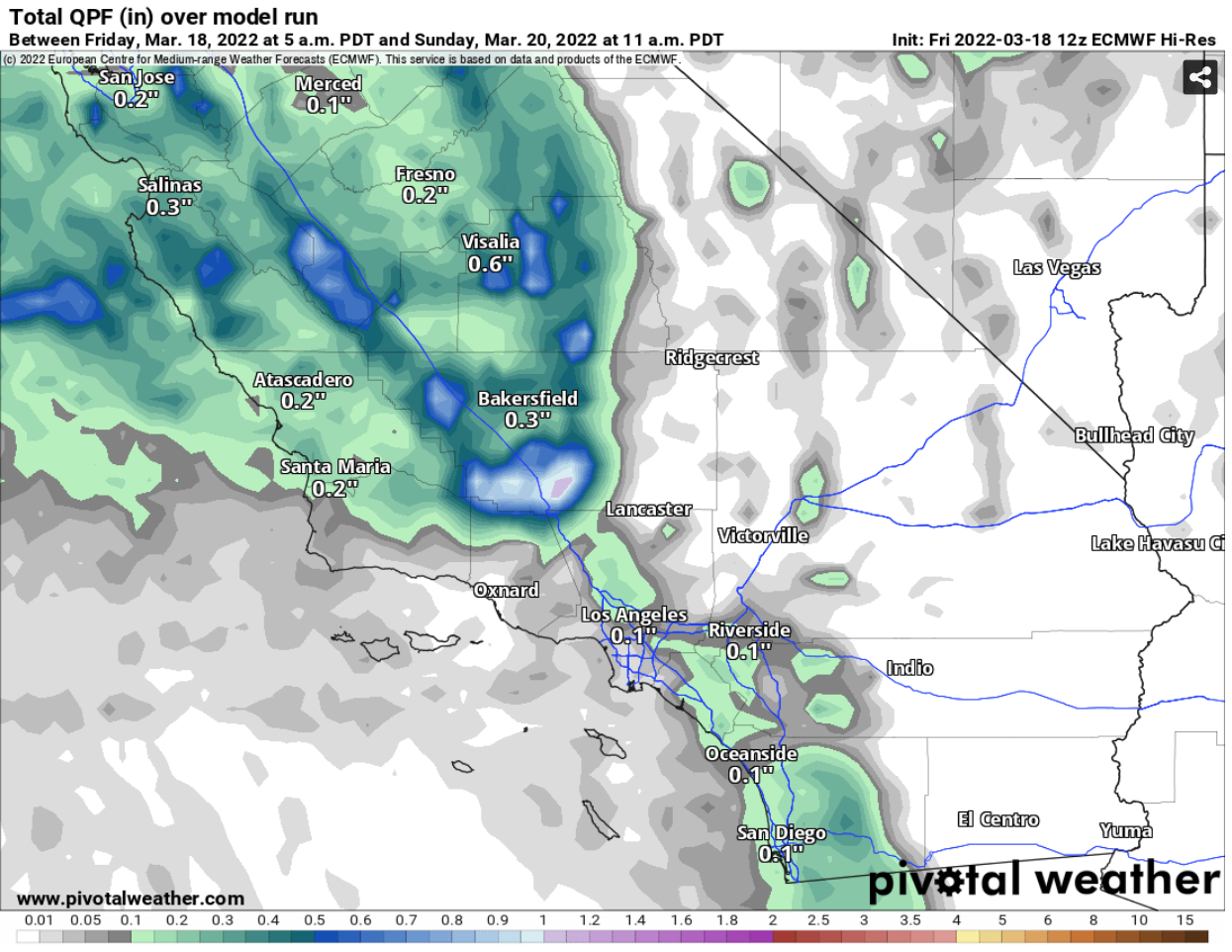
A small storm system will pass the area this weekend and bring a chance for a few showers from 9 PM Saturday to 9 AM Sunday. Rain totals will stay below 0.25" across the area. Snow levels will range from 7,000 to 9,000 feet, so local mountains won't see any snow.

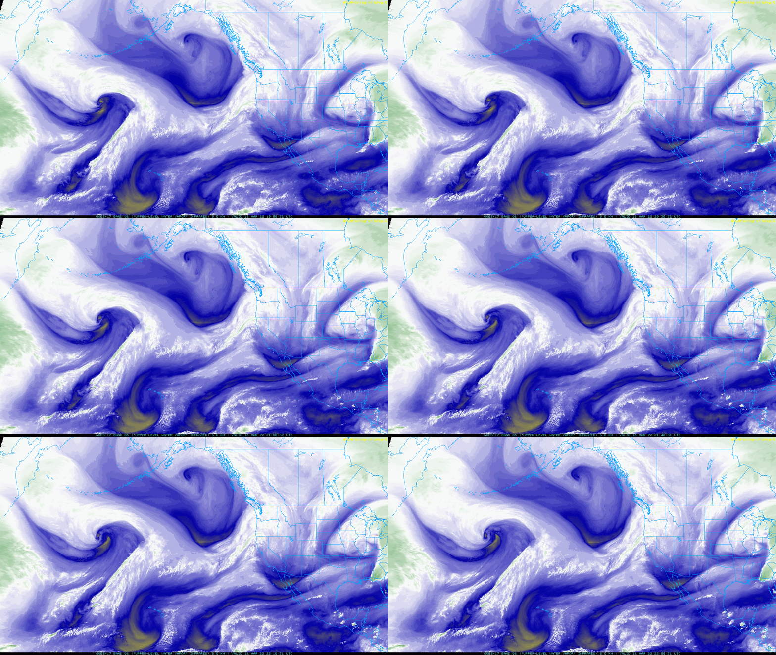
You can see a storm system spinning in the Gulf of Alaska in the satellite loop below. A piece of energy in the southern region of this system will break away and head southward towards Southern California.

This is a small system with limited moisture, so it won't bring the rainfall that we desperately need. I've posted the computer projected rain totals below. Some isolated areas in the mountains could receive a quarter inch of rainfall, otherwise, most areas will be much less, or see no rain at all.


NEXT RAIN CHANCE SAN DIEGO: UPDATED TUESDAY 3-8-2022

Over the next two days, a small storm system will dive southward along the western coastline of Canada and the United States. It will bring Southern California a quick chance for rain on Thursday.

An isolated light shower is possible Thursday morning (20%), then a better chance for a shower or quick downpour will arrive in the afternoon and early evening (40%). The rain chance will exit by 10 PM.

Snow levels will be fairly high for this event, 6,000 to 7,000 feet, so accumulations will be minimal to none.

SOUTHERN CALIFORNIA SNOW TOTALS: FRIDAY 3-4-2022 TO SATURDAY 3-6-2022

Here are the snow totals as of 9 AM this morning.

STATION               SNOWFALL(IN)         ELEVATION(FT)

BEAR MTN SNOW SUMMIT     15                    7200
SNOW VALLEY             10-12                  7000
BIG BEAR CITY            6-9                   6800
ARROWBEAR                6                     6200
RUNNING SPRINGS          6                     6200
PALOMAR MTN BIRCH HILL   5                     5600
CRESTLINE                4                     5200
CRESTLINE                4                     4600
TWIN PEAKS               4                     5700
MOUNT LAGUNA             3                     6000
WRIGHTWOOD               2                     6300
LUCERNE VALLEY           1                     3500
JULIAN                   1                     4000

SAN DIEGO RAIN TOTALS: SATURDAY 3-5-2022

Agua Caliente (AGUC1)0.07
Alpine (ANEC1)0.27
Barona (BNAC1)0.15
Barret Lake (BRTC1)0.61
Barrett Junction (BAJC1)0.59
Birch Hill (IRCC1)0.03
Bonita (BNNC1)0.11
Bonsall (BOSC1)0.06
Borrego Palm Canyon (BRPC1)0.02
Borrego Springs (BGOC1)0.00
Brown Field (SDM)0.01
Cactus County Park (CCPC1)0.15
Cameron Guard Station (CMNC1)0.64
Camp Elliot (MPEC1)0.03
Campo (CMFC1)0.42
Case Springs (CSPC1)0.09
CMP Target Range (CTGC1)0.03
Core Grade Road (OLEC1)0.05
Couser Canyon (OUSC1)0.08
Coyote Cyn Creek (CCYC1)0.00
Cuyamaca Reservoir (CYDC1)0.10
Deer Springs (DRGC1)0.22
Descanso (DENC1)0.30
Descanso RS (DSCC1)0.39
Dulzura Summit (DULC1)0.21
Eastern Tanks (ETKC1)0.35
Echo Dell (ECDC1)0.31
El Cajon (LCKC1)0.07
El Camino Del Norte (ECMC1)0.07
El Capitan Dam (ELPC1)0.16
Encinitas (ENCC1)0.01
Escondido (ESOC1)0.01
Fallbrook 5NE (FBOC1)0.03
Fallbrook (FBZC1)0.03
Fallbrook (FLBC1)0.05
Fallbrook Community AP (L18)0.03
Fashion Valley (FSNC1)0.00
Flinn Springs (FLYC1)0.13
Goat Canyon (GOCC1)0.00
Goose Valley (GOSC1)0.14
Granite Hills (GRHC1)0.07
Harbison Canyon (HARC1)0.00
Henshaw Dam (HAWC1)0.66
Japatul Fire Station (JFSC1)0.46
Julian (JLNC1)0.14
Julian (JULC1)0.08
Kearny Mesa (KEAC1)0.01
La Jolla Amago (LJOC1)0.37
La Mesa (LMSC1)0.00
Lake Hodges (HODC1)0.04
Lake Morena (MRAC1)0.48
Lake Murray (MUYC1)0.00
Las Flores (LSFC1)0.06
Lindbergh Int'l Airport (SAN)0.01
Loma Tova (LMTB1)0.00
Lower Oat Flats (OFLC1)0.05
Mesa Grande (MEGC1)0.58
Miramar Lake (MMRC1)0.05
Miramar Marine Corps Station (NKX)0.04
Mission Valley (BVDC1)0.00
Missle (MSXC1)0.09
Montgomery Field (MYF)0.02
Mount Laguna (LGMC1)0.01
Mt Woodson Rd - Ramona (RMAC1)0.19
North Island NAS (NZY)0.04
Oak Grove (OGVC1)0.03
Oceanside (OCNC1)0.09
Oceanside (OKB)0.02
Otay Mountain (OTYC1)0.14
Pala 2W (PZAC1)0.04
Palomar Airport (CRQ)0.00
Palomar Airport (PLMC1)0.00
Palomar Mountain (PRMC1)0.04
Palomar Mountain CRS (PMMC1)0.07
Palomar Mountain USFS (PAMC1)0.04
Pine Hills (PIHC1)0.58
Pine Hills Fire Station (PHIC1)0.77
Pine Valley County Park (PNVC1)0.34
Point Loma (L13)0.02
Potrero (PRCC1)0.33
Potrero CDF (POTC1)0.27
Poway (PWYC1)0.03
Rainbow Camp (RAIC1)0.06
Rainbow County Park (RABC1)0.06
Ramona (RMNC1)0.25
Ramona (RNM)0.22
Ranchita (RTAC1)0.15
Ranchita CDF (RCHC1)0.04
Ranchita Margarita (RMGC1)0.50
Rancho Bernardo (RNBC1)0.14
Red Gate Repeater (RGPC1)0.15
Rincon Springs (RINC1)0.13
Roads Division 1 HQ (RDHC1)0.06
San Diego Estates (ESTC1)0.24
San Felipe Valley (SFVC1)0.08
San Marcos Cnty Rd Station (SMXC1)0.02
San Marcos Landfill (NMLC1)0.01
San Miguel (MIGC1)0.07
San Pasqual (PSQC1)0.03
San Ysidro (YSDC1)0.04
Santa Rosa Plateau (SRUC1)0.02
Santa Ysabel (SYSC1)0.26
Santee - Mast Rd (STEC1)0.04
Skyline Ranch (SKLC1)0.45
Smugglers Gulch (UGGC1)0.00
Sutherland Dam (SUDC1)0.19
Talega (TLGC1)0.00
Temecula (TEMC1)0.04
Thousand Trails - Jamul (TTRC1)0.15
Tierra Del Sol (TRRC1)0.16
Tijuana Estuary (TJEC1)0.08
Tijuana R - Int'l Boundary (TIJC1)0.05
Valley Center (VALC1)0.25
Valley Center (VLCC1)0.38
Volcano Mountain (VCNC1)0.03
Warner Springs (WSGC1)0.23
Wire Mountain (WIRC1)0.00
Witch Creek Fire Station (WCHC1)0.18
Wohlford Dam (WHLC1)0.07

SAN DIEGO RAIN TOTALS: FRIDAY 3-4-2022


Agua Caliente (AGUC1)0.00
Alpine (ANEC1)0.47
Barona (BNAC1)0.65
Barret Lake (BRTC1)0.61
Birch Hill (IRCC1)0.84
Bonita (BNNC1)0.74
Bonsall (BOSC1)0.24
Borrego Palm Canyon (BRPC1)0.03
Borrego Springs (BGOC1)0.00
Brown Field (SDM)0.82
Cactus County Park (CCPC1)0.84
Camp Elliot (MPEC1)0.67
Campo (CMFC1)0.93
Case Springs (CSPC1)0.12
CMP Target Range (CTGC1)0.56
Core Grade Road (OLEC1)0.45
Couser Canyon (OUSC1)0.43
Coyote Cyn Creek (CCYC1)0.06
Cuyamaca Reservoir (CYDC1)0.96
Deer Springs (DRGC1)0.89
Descanso RS (DSCC1)0.61
Dulzura Summit (DULC1)0.50
Eastern Tanks (ETKC1)0.47
Echo Dell (ECDC1)0.53
El Cajon (LCKC1)0.85
El Camino Del Norte (ECMC1)0.88
El Capitan Dam (ELPC1)0.60
Encinitas (ENCC1)1.27
Escondido (ESOC1)0.74
Fallbrook 5NE (FBOC1)0.40
Fallbrook (FBZC1)0.17
Fallbrook (FLBC1)0.34
Fallbrook Community AP (L18)0.38
Fashion Valley (FSNC1)0.48
Flinn Springs (FLYC1)0.73
Goose Valley (GOSC1)0.62
Granite Hills (GRHC1)0.69
Harbison Canyon (HARC1)0.00
Henshaw Dam (HAWC1)0.86
Japatul Fire Station (JFSC1)0.62
Julian (JLNC1)0.44
Julian (JULC1)0.58
Kearny Mesa (KEAC1)0.64
La Jolla Amago (LJOC1)0.63
La Mesa (LMSC1)0.81
Lake Hodges (HODC1)0.82
Lake Morena (MRAC1)0.69
Lake Murray (MUYC1)1.18
Las Flores (LSFC1)0.22
Loma Tova (LMTB1)0.04
Lower Oat Flats (OFLC1)0.64
Marron Valley (MAVC1)0.35
Mesa Grande (MEGC1)0.68
Miramar Lake (MMRC1)0.47
Miramar Marine Corps Station (NKX)0.58
Missle (MSXC1)0.66
Montgomery Field (MYF)0.46
Mount Laguna (LGMC1)0.57
Mt Woodson Rd - Ramona (RMAC1)0.63
North Island NAS (NZY)0.31
Oak Grove (OGVC1)0.40
Oceanside (OCNC1)0.28
Oceanside (OKB)0.28
Otay Mountain (OTYC1)0.95
Palomar Airport (CRQ)0.51
Palomar Airport (PLMC1)0.54
Palomar Mountain (PRMC1)0.77
Palomar Mountain CRS (PMMC1)0.94
Pine Hills Fire Station (PHIC1)0.86
Pine Valley County Park (PNVC1)0.60
Point Loma (L13)0.47
Potrero (PRCC1)0.80
Potrero CDF (POTC1)0.91
Poway (PWYC1)0.64
Rainbow Camp (RAIC1)0.23
Rainbow County Park (RABC1)0.41
Ramona (RMNC1)0.63
Ramona (RNM)0.56
Ranchita (RTAC1)0.27
Ranchita CDF (RCHC1)0.25
Ranchita Margarita (RMGC1)0.78
Rancho Bernardo (RNBC1)0.62
Red Gate Repeater (RGPC1)0.71
Rincon Springs (RINC1)0.81
Roads Division 1 HQ (RDHC1)0.98
San Diego Estates (ESTC1)0.47
San Felipe Valley (SFVC1)0.12
San Marcos Cnty Rd Station (SMXC1)0.87
San Marcos Landfill (NMLC1)0.98
San Ysidro (YSDC1)0.47
Santa Rosa Plateau (SRUC1)0.52
Santa Ysabel (SYSC1)0.71
Santee - Mast Rd (STEC1)0.93
Skyline Ranch (SKLC1)0.57
Smugglers Gulch (UGGC1)0.27
Sutherland Dam (SUDC1)0.59
Talega (TLGC1)0.05
Temecula (TEMC1)0.51
Thousand Trails - Jamul (TTRC1)0.44
Tierra Del Sol (TRRC1)0.69
Tijuana Estuary (TJEC1)0.23
Valley Center (VALC1)0.87
Valley Center (VLCC1)0.92
Volcano Mountain (VCNC1)0.48
Warner Springs (WSGC1)0.50
Wire Mountain (WIRC1)0.30
Witch Creek Fire Station (WCHC1)0.61
Wohlford Dam (WHLC1)0.69


WEATHER UPDATE: FRIDAY 3-4-2022

Here is what to expect for the rest of this rain event:

Friday
The initial round of heavy rain and thunderstorms have exited. Another round of showers and isolated downpours will move through the area 7 AM to 11 AM. Then an isolated shower will be possible for the rest of the day, especially in the mountains. Snow levels will range from 5,500 to 6,500 feet.

Saturday
Isolated showers are possible in the morning, then scattered showers are possible in the afternoon and especially in the evening. Rain chance exits Saturday night. Snow levels will range from 4,500 to 5,500 feet.

NEXT RAIN CHANCE SAN DIEGO: UPDATED TUESDAY 3-1-2022

A couple storm systems will pass the area and bring rain back to our area Thursday night into early Friday. Periods of rain will then persist intermittently through Saturday. 

In the satellite loop below, you can see the first system several hundred miles off the coast in the Pacific Ocean. The second system is farther north developing in the Gulf of Alaska.

Rain totals will range from 0.25" to 1" for coastal and inland areas. Mountains could receive 1 to 2". Snow levels should drop low enough for a few inches of snowfall in local mountains.

I've posted the computer projected rain and snow totals below.


FORECAST

HOURLY TEMPERATURE FORECAST

COAST INLAND

BLOG ARCHIVE