Here a few webcam shots from the mountains this morning: Mount Laguna, Boucher Hill and Sky Oaks.
 |
| Mount Laguna |
 |
| Mount Laguna |
 |
| Boucher Hill |
 |
| Sky Oaks |
 |
| Sky Oaks |

Here a few webcam shots from the mountains this morning: Mount Laguna, Boucher Hill and Sky Oaks.
|
| Mount Laguna |
|
| Mount Laguna |
|
| Boucher Hill |
|
| Sky Oaks |
|
| Sky Oaks |
Here are the snow totals at 5 PM Wednesday. As always, you can find the latest road conditions at the following link: https://roads.dot.ca.gov/
STATION              SNOWFALL(IN)    ELEVATION(FT)  TIME/DATE

MT LAGUNA                   14          6000         800AM 2/23
BIG BEAR MTN RESORT        12-13        7000         300PM 2/23
SNOW SUMMIT                 12          7000         300PM 2/23
BAY TREE SPGS (HWY 243)     12          6000         700AM 2/23
BIRCH HILL (PALOMAR MTN)    12.5        5700         100PM 2/23
PINE COVE                   10.5        6000         830AM 2/23
PALOMAR OBSERVATORY         10          6100         900AM 2/23
LAKE ARROWHEAD               8          5200        1100AM 2/23
PALOMAR MTN                  7          5500         730AM 2/23
ARROWBEAR                   7-8         6086         640AM 2/23
BIG BEAR CITY               6-8         6800         300PM 2/23
GREEN VALLEY LAKE            7          7000         800AM 2/23
FOREST FALLS                 6          9000         800AM 2/23
BARTON FLATS                 6          6900         800AM 2/23
BIG BEAR YARD                6          6800         800AM 2/23
WRIGHTWOOD                   6          5900         800AM 2/23
CRESTLINE YARD              5.5         4850         800AM 2/23
SNOW VALLEY                  5          7000-7500    630PM 2/22
RUNNING SPRINGS              5          6200         800AM 2/23
ARROWBEAR LAKE               5          6190         800AM 2/23
ANGELUS OAKS                 5          5780         800AM 2/23
OAK GLEN                     5          4900         800AM 2/23
JULIAN                       3          4100         700AM 2/23
MT BALDY (SNOW SPORTS)      2-3         7000         800AM 2/23
CRESTLINE                    2          4800         730AM 2/23
END OF MT BALDY RD           2          6300         800AM 2/23
LAKE MORENA                  2          3100        1000AM 2/23
GUATAY (NEAR PINE VALLEY)    1          4000         650AM 2/23
CHERRY VALLEY                1          3000         300AM 2/23
DESCANSO                     1          3400         730AM 2/23
MT BALDY VILLAGE             1          4200         800AM 2/23
CAMPO                       0.5         2600         730AM 2/23
Here are the rain totals at 7 AM Wednesday. Isolated showers are still possible until midday, so I'll update the numbers later today. Coastal and inland areas received 0.2 to 1.0", while the mountains received 1.0 to 2.0" rain equivalent of snowfall. I'll post snow totals later today.
 |
| Click to enlarge map |
| Agua Caliente (AGUC1) | 0.33 |
| Alpine (ANEC1) | 1.16 |
| Barona (BNAC1) | 0.68 |
| Barret Lake (BRTC1) | 1.44 |
| Barrett Junction (BAJC1) | 1.74 |
| Birch Hill (IRCC1) | 0.01 |
| Bonita (BNNC1) | 0.69 |
| Bonsall (BOSC1) | 0.28 |
| Borrego Palm Canyon (BRPC1) | 0.56 |
| Borrego Springs (BGOC1) | 0.12 |
| Brown Field (SDM) | 0.91 |
| Cactus County Park (CCPC1) | 0.90 |
| Cameron Guard Station (CMNC1) | 1.47 |
| Camp Elliot (MPEC1) | 0.76 |
| Campo (CMFC1) | 1.54 |
| Case Springs (CSPC1) | 0.48 |
| CMP Target Range (CTGC1) | 0.19 |
| Core Grade Road (OLEC1) | 0.86 |
| Couser Canyon (OUSC1) | 0.33 |
| Coyote Cyn Creek (CCYC1) | 0.23 |
| Cuyamaca Reservoir (CYDC1) | 1.74 |
| Deer Springs (DRGC1) | 0.35 |
| Descanso (DENC1) | 1.21 |
| Descanso RS (DSCC1) | 1.69 |
| Dulzura Summit (DULC1) | 0.92 |
| Eastern Tanks (ETKC1) | 1.03 |
| Echo Dell (ECDC1) | 1.55 |
| El Cajon (LCKC1) | 0.71 |
| El Capitan Dam (ELPC1) | 1.40 |
| Encinitas (ENCC1) | 0.24 |
| Escondido (ESOC1) | 0.51 |
| Fallbrook 5NE (FBOC1) | 0.21 |
| Fallbrook (FBZC1) | 0.37 |
| Fallbrook (FLBC1) | 0.33 |
| Fallbrook Community AP (L18) | 0.23 |
| Fashion Valley (FSNC1) | 0.34 |
| Flinn Springs (FLYC1) | 1.00 |
| Goose Valley (GOSC1) | 0.92 |
| Granite Hills (GRHC1) | 0.57 |
| Harbison Canyon (HARC1) | 0.00 |
| Henshaw Dam (HAWC1) | 1.29 |
| Japatul Fire Station (JFSC1) | 1.90 |
| Julian (JLNC1) | 1.02 |
| Julian (JULC1) | 1.21 |
| Kearny Mesa (KEAC1) | 0.32 |
| La Jolla Amago (LJOC1) | 0.20 |
| La Mesa (LMSC1) | 0.68 |
| Lake Hodges (HODC1) | 0.52 |
| Lake Morena (MRAC1) | 0.92 |
| Lake Murray (MUYC1) | 0.56 |
| Las Flores (LSFC1) | 0.20 |
| Lindbergh Int'l Airport (SAN) | 0.48 |
| Loma Tova (LMTB1) | 0.04 |
| Lower Oat Flats (OFLC1) | 0.48 |
| Marron Valley (MAVC1) | 1.06 |
| Mesa Grande (MEGC1) | 1.48 |
| Miramar Lake (MMRC1) | 0.44 |
| Miramar Marine Corps Station (NKX) | 0.41 |
| Mission Valley (BVDC1) | 0.48 |
| Missle (MSXC1) | 0.79 |
| Montgomery Field (MYF) | 0.29 |
| Mount Laguna (LGMC1) | 0.17 |
| Mount Laguna (MLGC1) | 0.19 |
| Mt Woodson Rd - Ramona (RMAC1) | 1.03 |
| Oceanside (OKB) | 0.18 |
| Otay Mountain (OTYC1) | 1.68 |
| Pala 2W (PZAC1) | 0.33 |
| Palomar Airport (CRQ) | 0.24 |
| Palomar Airport (PLMC1) | 0.22 |
| Palomar Mountain (PRMC1) | 0.20 |
| Palomar Mountain CRS (PMMC1) | 0.41 |
| Pine Hills (PIHC1) | 1.72 |
| Pine Hills Fire Station (PHIC1) | 1.84 |
| Pine Valley County Park (PNVC1) | 1.85 |
| Point Loma (L13) | 0.31 |
| Potrero (PRCC1) | 1.98 |
| Potrero CDF (POTC1) | 1.60 |
| Poway (PWYC1) | 0.62 |
| Rainbow Camp (RAIC1) | 0.41 |
| Rainbow County Park (RABC1) | 0.39 |
| Ramona (RMNC1) | 0.86 |
| Ramona (RNM) | 1.02 |
| Ranchita (RTAC1) | 0.33 |
| Ranchita CDF (RCHC1) | 0.19 |
| Ranchita Margarita (RMGC1) | 1.83 |
| Rancho Bernardo (RNBC1) | 0.67 |
| Red Gate Repeater (RGPC1) | 0.71 |
| Rincon Springs (RINC1) | 0.36 |
| Roads Division 1 HQ (RDHC1) | 0.54 |
| San Diego Estates (ESTC1) | 0.51 |
| San Felipe Valley (SFVC1) | 0.48 |
| San Marcos Cnty Rd Station (SMXC1) | 0.37 |
| San Marcos Landfill (NMLC1) | 0.39 |
| San Pasqual (PSQC1) | 0.41 |
| San Ysidro (YSDC1) | 0.79 |
| Santa Rosa Plateau (SRUC1) | 0.41 |
| Santa Ysabel (SYSC1) | 1.44 |
| Santee - Mast Rd (STEC1) | 0.59 |
| Skyline Ranch (SKLC1) | 0.75 |
| Smugglers Gulch (UGGC1) | 0.67 |
| Sutherland Dam (SUDC1) | 1.23 |
| Talega (TLGC1) | 0.45 |
| Temecula (TEMC1) | 0.43 |
| Thousand Trails - Jamul (TTRC1) | 1.22 |
| Tierra Del Sol (TRRC1) | 1.25 |
| Tijuana Estuary (TJEC1) | 0.63 |
| Valley Center (VLCC1) | 0.64 |
| Volcano Mountain (VCNC1) | 0.41 |
| Warner Springs (WSGC1) | 0.57 |
| Wire Mountain (WIRC1) | 0.11 |
| Witch Creek Fire Station (WCHC1) | 1.25 |
| Wohlford Dam (WHLC1) | 0.57 |
Computer projections have remained solid, so there are no changes to the forecast. Rain totals will range from 1.0" to 1.5" for coastal and inland areas. Several inches of snow are possible above 4,000 feet, with totals easily approaching over 12" above 6,000 feet.
Here is a timeline for Tuesday and Wednesday:
Tuesday 7 AM to Noon
A few showers along the coast and inland, especially near midday. Patchy rain in the mountains. Snow levels 4,500 to 5,500 feet.
Tuesday Noon to 5 PM
Intermittent showers and isolated downpours. Snow levels 4,500 to 5,000 feet.
Tuesday 5 PM to 10 PM
Rain likely, heavy at times, isolated thunderstorms. Snow levels 4,000 to 5,000 feet.
Tuesday Night
Scattered showers, isolated downpours and thunderstorms. Snow levels 3,000 to 4,000 feet.
Wednesday 7 AM to Noon
Intermittent showers taper to isolated showers. Persistent rain and snow in higher elevations. Snow levels 3,000 to 4,000 feet.
Wednesday Noon to 5 PM
Showers exit along the coast and inland. Mountain snow showers taper. Snow levels 3,000 to 4,000 feet.
 |
| Computer projections for rainfall through Wednesday evening |
 |
| Computer projections for snowfall through Wednesday evening |
Rain showers and mountain snow should return to the area early next week. Computer projections have been consistent over the past few days, which gives me some confidence with this forecast.
Isolated light showers are possible Monday through early Tuesday. Snow levels will range from 9,000 feet to 10,000 feet during this time period.
The core of the system will then settle in late Tuesday and bring more scattered showers to the area. Snow levels will rapidly drop to 4,000 to 5,000 feet Tuesday night. Some isolated areas could be lower.
Intermittent showers and mountain snow will persist through early Wednesday, then taper by Wednesday evening.
Unfortunately, there won't be much moisture associated with this system - the atmospheric river will be almost nonexistent. This will limit the rain potential, but we'll take whatever we can get! It will also be nice to see some snow in our local mountains.
I've included the computer projections for total rain and snow below. These totals are heavily dependent on the track of this system, so I will bring updates if/when needed.
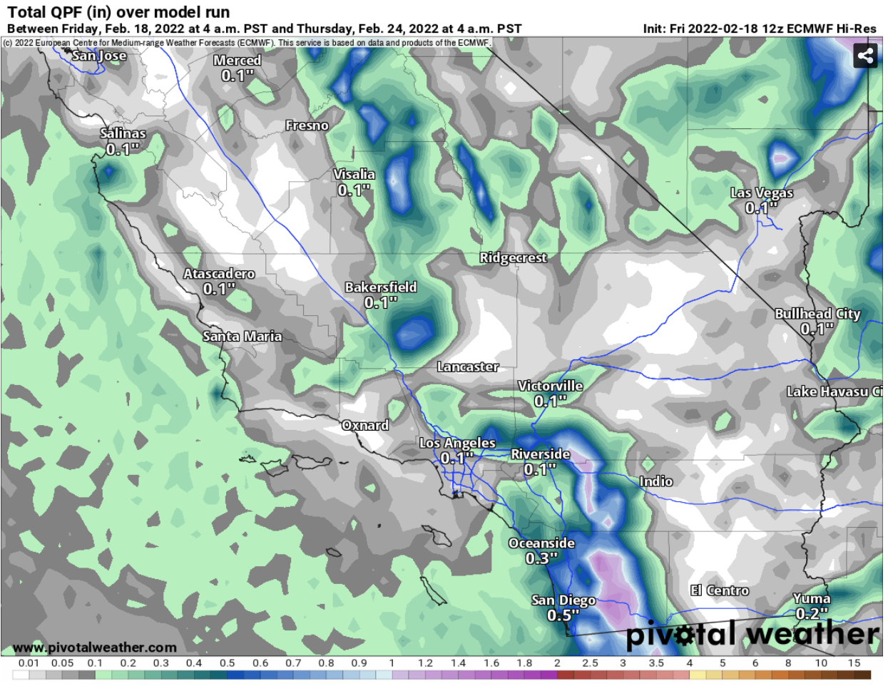 |
| Computer projected rainfall through next Thursday morning |
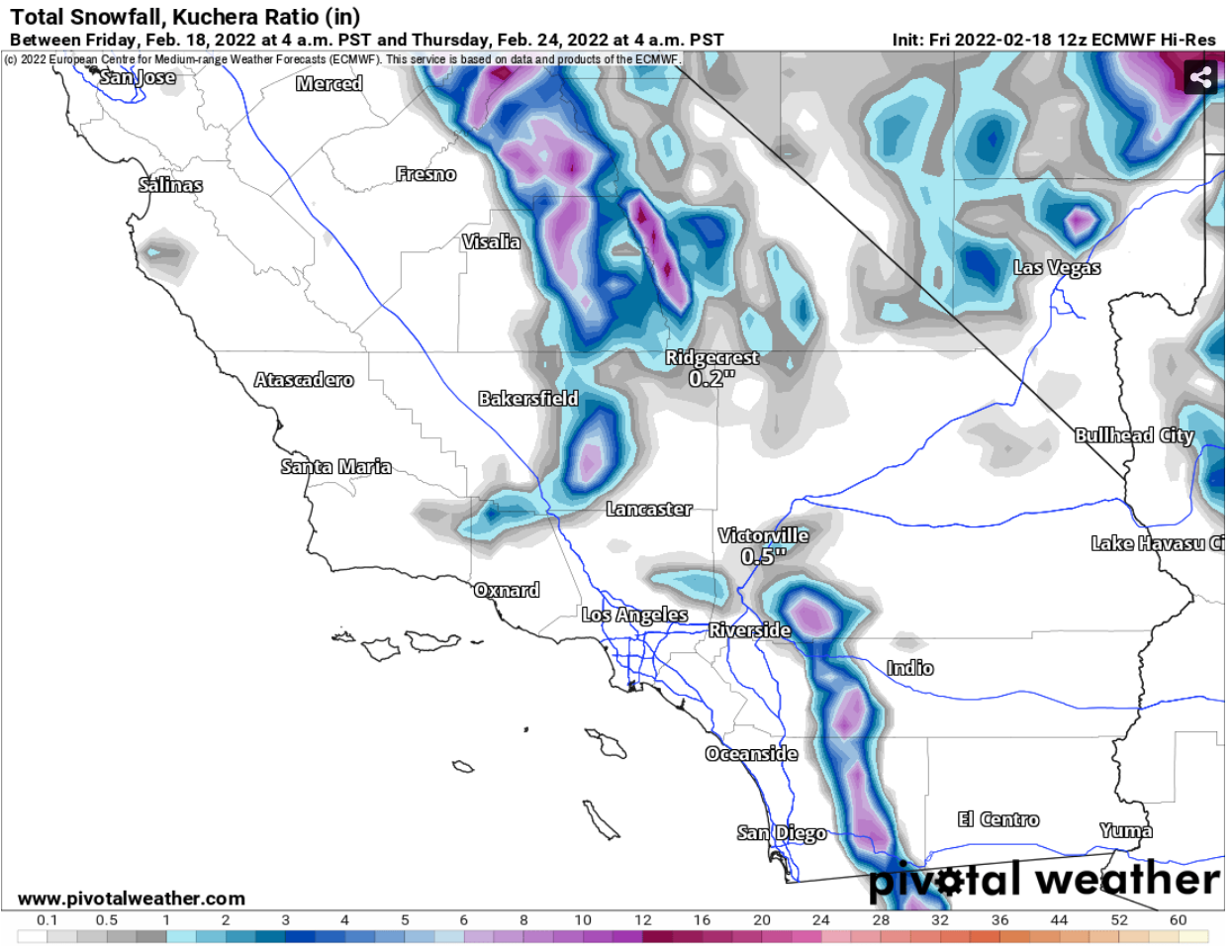 |
| Computer projected snowfall through next Thursday morning |
Here are some images from webcams of snow on local mountains.
 |
| Mount Laguna looking north |
 |
| Mount Laguna looking north |
 |
| Cuyamaca looking north |
 |
| Santiago Peak looking north |
 |
| Sky Oaks looking north |
 |
| Mount Wilson Observatory looking north |
 |
| Boucher Hill looking north |
Coastal and inland rain totals were 0.1 to 0.3", while mountain areas received 0.5 to 1.0".
 |
| Click map to enlarge |
| Agua Caliente (AGUC1) | 0.08 |
| Barona (BNAC1) | 0.42 |
| Barret Lake (BRTC1) | 0.27 |
| Barrett Junction (BAJC1) | 0.40 |
| Birch Hill (IRCC1) | 0.20 |
| Bonita (BNNC1) | 0.20 |
| Bonsall (BOSC1) | 0.03 |
| Borrego Palm Canyon (BRPC1) | 0.06 |
| Borrego Springs (BGOC1) | 0.03 |
| Brown Field (SDM) | 0.42 |
| Cactus County Park (CCPC1) | 0.20 |
| Camp Elliot (MPEC1) | 0.32 |
| Campo (CMFC1) | 0.47 |
| Case Springs (CSPC1) | 0.32 |
| CMP Target Range (CTGC1) | 0.14 |
| Core Grade Road (OLEC1) | 0.15 |
| Couser Canyon (OUSC1) | 0.11 |
| Coyote Cyn Creek (CCYC1) | 0.00 |
| Cuyamaca Reservoir (CYDC1) | 0.46 |
| Deer Springs (DRGC1) | 0.25 |
| Descanso (DENC1) | 0.38 |
| Descanso RS (DSCC1) | 0.44 |
| Dulzura Summit (DULC1) | 0.27 |
| Eastern Tanks (ETKC1) | 0.27 |
| Echo Dell (ECDC1) | 0.44 |
| El Cajon (LCKC1) | 0.35 |
| El Capitan Dam (ELPC1) | 0.56 |
| Encinitas (ENCC1) | 0.04 |
| Escondido (ESOC1) | 0.26 |
| Fallbrook 5NE (FBOC1) | 0.15 |
| Fallbrook (FBZC1) | 0.20 |
| Fallbrook (FLBC1) | 0.08 |
| Fallbrook Community AP (L18) | 0.05 |
| Fashion Valley (FSNC1) | 0.16 |
| Flinn Springs (FLYC1) | 0.43 |
| Goat Canyon (GOCC1) | 0.04 |
| Goose Valley (GOSC1) | 0.47 |
| Granite Hills (GRHC1) | 0.29 |
| Harbison Canyon (HARC1) | 0.22 |
| Henshaw Dam (HAWC1) | 0.37 |
| Japatul Fire Station (JFSC1) | 0.47 |
| Julian (JLNC1) | 0.47 |
| Julian (JULC1) | 0.43 |
| Kearny Mesa (KEAC1) | 0.27 |
| La Jolla Amago (LJOC1) | 0.28 |
| La Mesa (LMSC1) | 0.17 |
| Lake Hodges (HODC1) | 0.33 |
| Lake Morena (MRAC1) | 0.64 |
| Lake Murray (MUYC1) | 0.15 |
| Las Flores (LSFC1) | 0.00 |
| Lindbergh Int'l Airport (SAN) | 0.18 |
| Loma Tova (LMTB1) | 0.00 |
| Lower Oat Flats (OFLC1) | 0.40 |
| Marron Valley (MAVC1) | 0.08 |
| Mesa Grande (MEGC1) | 0.60 |
| Miramar Lake (MMRC1) | 0.24 |
| Mission Valley (BVDC1) | 0.17 |
| Missle (MSXC1) | 0.40 |
| Montgomery Field (MYF) | 0.57 |
| Mount Laguna (LGMC1) | 0.06 |
| Mount Laguna (MLGC1) | 0.08 |
| Mt Woodson Rd - Ramona (RMAC1) | 0.70 |
| North Island NAS (NZY) | 0.16 |
| Oak Grove (OGVC1) | 0.13 |
| Oceanside (OCNC1) | 0.00 |
| Oceanside (OKB) | 0.03 |
| Otay Mountain (OTYC1) | 0.78 |
| Pala 2W (PZAC1) | 0.33 |
| Palomar Airport (CRQ) | 0.03 |
| Palomar Airport (PLMC1) | 0.03 |
| Palomar Mountain (PRMC1) | 0.16 |
| Palomar Mountain CRS (PMMC1) | 0.55 |
| Palomar Mountain USFS (PAMC1) | 0.15 |
| Pine Hills (PIHC1) | 0.74 |
| Pine Hills Fire Station (PHIC1) | 0.81 |
| Pine Valley County Park (PNVC1) | 0.42 |
| Point Loma (L13) | 0.10 |
| Potrero (PRCC1) | 0.49 |
| Potrero CDF (POTC1) | 0.39 |
| Poway (PWYC1) | 0.39 |
| Rainbow Camp (RAIC1) | 0.28 |
| Rainbow County Park (RABC1) | 0.23 |
| Ramona (RMNC1) | 0.56 |
| Ramona (RNM) | 0.56 |
| Ranchita (RTAC1) | 0.07 |
| Ranchita CDF (RCHC1) | 0.03 |
| Ranchita Margarita (RMGC1) | 0.84 |
| Rancho Bernardo (RNBC1) | 0.19 |
| Red Gate Repeater (RGPC1) | 0.16 |
| Rincon Springs (RINC1) | 0.15 |
| Roads Division 1 HQ (RDHC1) | 0.15 |
| San Diego Estates (ESTC1) | 0.60 |
| San Felipe Valley (SFVC1) | 0.15 |
| San Marcos Cnty Rd Station (SMXC1) | 0.11 |
| San Marcos Landfill (NMLC1) | 0.10 |
| San Miguel (MIGC1) | 0.22 |
| San Pasqual (PSQC1) | 0.19 |
| San Ysidro (YSDC1) | 0.08 |
| Santa Rosa Plateau (SRUC1) | 0.17 |
| Santa Ysabel (SYSC1) | 0.75 |
| Santee - Mast Rd (STEC1) | 0.31 |
| Skyline Ranch (SKLC1) | 0.25 |
| Smugglers Gulch (UGGC1) | 0.04 |
| Sutherland Dam (SUDC1) | 0.50 |
| Talega (TLGC1) | 0.16 |
| Temecula (TEMC1) | 0.24 |
| Thousand Trails - Jamul (TTRC1) | 0.43 |
| Tierra Del Sol (TRRC1) | 0.20 |
| Tijuana Estuary (TJEC1) | 0.04 |
| Valley Center (VALC1) | 0.25 |
| Valley Center (VLCC1) | 0.22 |
| Volcano Mountain (VCNC1) | 0.15 |
| Warner Springs (WSGC1) | 0.17 |
| Wire Mountain (WIRC1) | 0.01 |
| Witch Creek Fire Station (WCHC1) | 0.63 |
| Wohlford Dam (WHLC1) | 0.31 |
The high temperature in San Diego was 91, which shatters the record of 86. Here are the highs across the county.

| Alpine (ANEC1) | 78 |
| Barrett Junction (BAJC1) | 78 |
| Borrego Valley Airport (L08) | 59 |
| Brown Field (SDM) | 89 |
| Cameron Guard Station (CMNC1) | 73 |
| Camp Elliot (MPEC1) | 90 |
| Camp Pendleton (NFG) | 95 |
| Camp Pendleton (PPDC1) | 89 |
| Case Springs (CSPC1) | 80 |
| CMP Target Range (CTGC1) | 88 |
| Cuyamaca Reservoir (CYDC1) | 61 |
| Descanso (DENC1) | 75 |
| Eastern Tanks (ETKC1) | 75 |
| Fallbrook 5NE (FBOC1) | 88 |
| Fallbrook (FBZC1) | 87 |
| Fallbrook Community AP (L18) | 89 |
| Gillespie Field Airport (SEE) | 90 |
| Goose Valley (GOSC1) | 83 |
| Imperial Beach (TIXC1) | 91 |
| Japatul Fire Station (JFSC1) | 80 |
| Julian (JLNC1) | 68 |
| Julian (JULC1) | 67 |
| Lake Murray (MUYC1) | 90 |
| Las Flores (LSFC1) | 85 |
| Lindbergh Int'l Airport (SAN) | 91 |
| MCOLF - Red Beach (NXF) | 75 |
| Miramar Marine Corps Station (NKX) | 88 |
| Mission Valley (BVDC1) | 89 |
| Missle (MSXC1) | 88 |
| Montgomery Field (MYF) | 89 |
| Mount Laguna (MLGC1) | 62 |
| North Island NAS (NZY) | 90 |
| Oak Grove (OGVC1) | 79 |
| Oceanside (OKB) | 82 |
| Otay Mountain (OTYC1) | 72 |
| Pala 2W (PZAC1) | 91 |
| Palomar Airport (CRQ) | 86 |
| Palomar Mountain USFS (PAMC1) | 66 |
| Pine Hills (PIHC1) | 72 |
| Potrero CDF (POTC1) | 77 |
| Ramona (RNM) | 85 |
| Ranchita CDF (RCHC1) | 68 |
| San Marcos Landfill (NMLC1) | 88 |
| San Miguel (MIGC1) | 89 |
| San Pasqual (PSQC1) | 90 |
| Santa Rosa Plateau (SRUC1) | 83 |
| Talega (TLGC1) | 88 |
| Tijuana Estuary (TJEC1) | 90 |
| Valley Center (VLCC1) | 83 |
| Wire Mountain (WIRC1) | 88 |
I'm watching a small storm system in the Gulf of Alaska (highlighted in the map below). This system will dive southward for the start of the upcoming workweek and bring a slight chance for an isolated shower on Tuesday (30%). Unfortunately, the track is too far inland to bring us the rainfall we need. At least this front will drop our temperatures back into the 60s and 70s for the workweek.
Another system will take a similar track the following week. It will have more strength, though the track is still uncertain - this is several days away. Right now, the computer forecasts are showing a chance for rain around Monday 2/21 or Tuesday 2/22. I'll keep watching and bring updates as it approaches.


Although California had a wet end to last December, most areas have been mainly dry since. La Niña persists in the equatorial Pacific, which usually equates to dry conditions across the state. Unfortunately, it looks like this type of pattern will persist through most of this month. The first map below shows that most of California is drier than average for this rain season, especially in the southern third of the state.

Computer projections show a blocking pattern in the upper atmosphere, which means that most of the West Coast will remain dry.

This blocking pattern also means we will see warmer than normal temperatures.

This is a terrible pattern for rainfall. Looking at long range computer projections, most of California will stay dry for the next couple weeks.

La Niña persists in the equatorial Pacific. This will have a big influence on our weather.

This next map shows water temperatures below the surface. A warm ocean current is developing, indicating a potential El Niño in the future. Unfortunately, it might come too late for this rain season.

 INLAND
