ADVERTISEMENT

SANTA BARBARA QUESTION

Someone on this blog recently posted an interesting question about one of the climate maps.

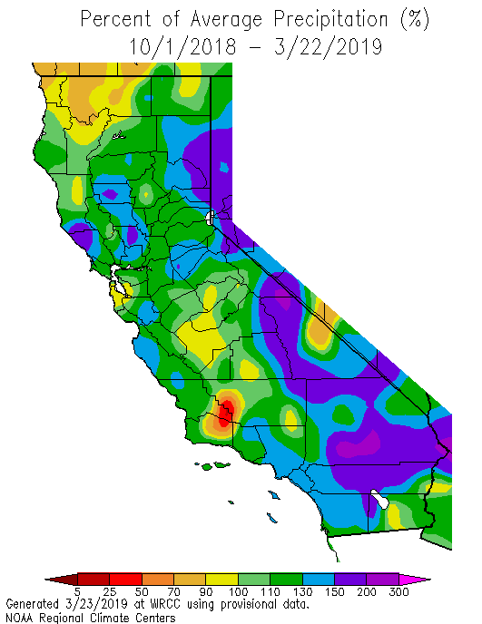
I don’t even live in San Diego anymore, but still like to reference your website to see what is happening with CA rainfall. I notice that for several weeks that the percentage of average rainfall maps have a red (very below average) spot north/northeast of Santa Barbara. Do you think that is an error in reporting from that weather station, or is that area really so short on rainfall?

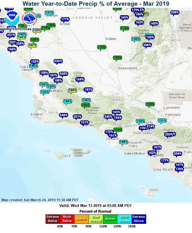
The first map below is the one in question. I'm guessing it's a plotting error, because I've posted two more maps below that show that most areas around Santa Barbara are well above normal for rainfall.

Great question and good eye!


SAN DIEGO RAIN TOTALS: WEDNESDAY 3-20-2019 TO THURSDAY 3-21-2019

I'm going to use this blog post for a 2 day running total of rainfall Wednesday and Thursday.

**Updated 7 PM Thursday.


Barona (BNAC1)0.20
Birch Hill (IRCC1)0.54
Bonita (BNNC1)0.33
Bonsall (BOSC1)0.05
Cactus County Park (CCPC1)0.19
Camp Pendleton (NFG)0.36
Cuyamaca Reservoir (CYDC1)0.83
Deer Springs (DRGC1)0.38
Descanso RS (DSCC1)0.88
Dulzura Summit (DULC1)0.40
Eastern Tanks (ETKC1)0.24
Echo Dell (ECDC1)0.33
El Cajon (LCKC1)0.16
El Camino Del Norte (ECMC1)0.11
El Capitan Dam (ELPC1)0.25
Encinitas (ENCC1)0.16
Escondido (ESOC1)0.56
Fashion Valley (FSNC1)0.16
Flinn Springs (FLYC1)0.51
Granite Hills (GRHC1)0.17
Harbison Canyon (HARC1)0.21
Henshaw Dam (HAWC1)0.28
Julian (JLNC1)0.79
Kearny Mesa (KEAC1)0.26
La Jolla Amago (LJOC1)0.29
La Mesa (LMSC1)0.22
Lake Hodges (HODC1)0.48
Las Flores (LSFC1)0.08
Lindbergh Int'l Airport (SAN)0.39
Mesa Grande (MEGC1)0.37
Miramar Lake (MMRC1)0.52
Mission Valley (BVDC1)0.29
Mt Woodson Rd - Ramona (RMAC1)0.33
Oceanside (OCNC1)0.12
Palomar Airport (PLMC1)0.33
Palomar Mountain CRS (PMMC1)0.63
Pine Hills Fire Station (PHIC1)0.79
Potrero (PRCC1)0.36
Poway (PWYC1)0.22
Ramona (RMNC1)0.71
Rancho Bernardo (RNBC1)0.20
Red Gate Repeater (RGPC1)0.16
Rincon Springs (RINC1)0.37
Roads Division 1 HQ (RDHC1)0.47
San Diego Estates (ESTC1)0.27
San Marcos Landfill (NMLC1)0.19
San Pasqual (PSQC1)0.91
Santa Ysabel (SYSC1)0.36
Santee - Mast Rd (STEC1)0.23
Skyline Ranch (SKLC1)0.44
Solana Beach (SOB)0.26
Sutherland Dam (SUDC1)0.45
Tijuana Estuary (TJEC1)0.08
Vallecitos Repeater (VCIC1)0.24
Valley Center (VALC1)0.15
Volcano Mountain (VCNC1)0.69
Warner Springs (WSGC1)0.12
Wire Mountain (WIRC1)0.05
Witch Creek Fire Stn (WCHC1)0.59
Wohlford Dam (WHLC1)0.37

NEXT RAIN CHANCE SAN DIEGO: UPDATED SUNDAY 3-17-2019

The next storm system is now showing up on the Pacific satellite loop below. You can see that it doesn't have a moisture stream connecting from the south. This will significantly limit our rain amounts for the middle of the workweek.

Light showers will develop Tuesday night, then periods of rain will be possible through Wednesday. An isolated shower will be possible on Thursday as the center of the system passes overhead. Rain totals will generally be less than a half inch (map below).

Snow levels will range form 6,000-6,500 feet Tuesday night and drop to 5,000-5,000 feet by Thursday morning.

We could see another rain chance arriving by next weekend. I'll have another update as it approaches.


SAN DIEGO RAIN TOTALS: WEDNESDAY 3-13-2019

Here are the rain totals from last night.


Alpine (ANEC1)0.06
Barona (BNAC1)0.03
Barret Lake (BRTC1)0.05
Barrett Junction (BAJC1)0.04
Birch Hill (IRCC1)0.13
Bonita (BNNC1)0.00
Bonsall (BOSC1)0.05
Brown Field (SDM)0.02
Cactus County Park (CCPC1)0.02
Camp Pendleton (NFG)0.02
Cuyamaca Reservoir (CYDC1)0.07
Deer Springs (DRGC1)0.00
Descanso (DENC1)0.09
Descanso RS (DSCC1)0.10
Dulzura Summit (DULC1)0.04
Eastern Tanks (ETKC1)0.04
Echo Dell (ECDC1)0.03
El Cajon (LCKC1)0.04
El Camino Del Norte (ECMC1)0.03
Encinitas (ENCC1)0.00
Escondido (ESOC1)0.01
Fashion Valley (FSNC1)0.00
Flinn Springs (FLYC1)0.07
Goose Valley (GOSC1)0.02
Granite Hills (GRHC1)0.06
Harbison Canyon (HARC1)0.05
Henshaw Dam (HAWC1)0.05
Julian (JLNC1)0.08
Julian (JULC1)0.09
Kearny Mesa (KEAC1)0.04
La Jolla Amago (LJOC1)0.03
La Mesa (LMSC1)0.06
Lake Hodges (HODC1)0.00
Lake Murray (MUYC1)0.04
Las Flores (LSFC1)0.00
Lindbergh Int'l Airport (SAN)0.00
Marron Valley (MAVC1)0.11
Mesa Grande (MEGC1)0.10
Miramar Lake (MMRC1)0.03
Mission Valley (BVDC1)0.01
Montgomery Field (MYF)0.02
Mt Woodson Rd - Ramona (RMAC1)0.07
Oceanside (OCNC1)0.00
Oceanside (OKB)0.00
Palomar Airport (CRQ)0.00
Palomar Airport (PLMC1)0.00
Palomar Mountain CRS (PMMC1)0.12
Pine Hills (PIHC1)0.09
Potrero (PRCC1)0.06
Poway (PWYC1)0.01
Ramona (RMNC1)0.07
Ramona (RNM)0.06
Rancho Bernardo (RNBC1)0.03
Red Gate Repeater (RGPC1)0.04
Rincon Springs (RINC1)0.00
Roads Division 1 HQ (RDHC1)0.04
San Diego Estates (ESTC1)0.04
San Marcos Cnty Rd Stn (SMXC1)0.00
San Marcos Landfill (NMLC1)0.05
San Miguel (MIGC1)0.01
San Pasqual (PSQC1)0.01
San Ysidro (YSDC1)0.00
Santa Ysabel (SYSC1)0.05
Santee - Mast Rd (STEC1)0.05
Skyline Ranch (SKLC1)0.01
Sutherland Dam (SUDC1)0.04
Tijuana Estuary (TJEC1)0.00
Vallecitos Repeater (VCIC1)0.04
Valley Center (VALC1)0.02
Volcano Mountain (VCNC1)0.10
Warner Springs (WSGC1)0.01
Wire Mountain (WIRC1)0.00
Witch Creek Fire Stn (WCHC1)0.05
Wohlford Dam (WHLC1)0.01

SAN DIEGO RAIN TOTALS: MONDAY 3-11-2019 TO TUESDAY 3-12-2019

Showers have mostly dissipated across the area. Another quick round of light rain will develop this evening and tonight. Those showers will taper by early Wednesday morning. Here are the rain totals at 9 AM Tuesday.


Alpine (ANEC1)0.20
Barona (BNAC1)0.22
Barret Lake (BRTC1)0.16
Barrett Junction (BAJC1)0.19
Birch Hill (IRCC1)0.00
Bonita (BNNC1)0.36
Brown Field (SDM)0.42
Cactus County Park (CCPC1)0.23
Camp Pendleton (NFG)0.20
Cuyamaca Reservoir (CYDC1)0.20
Deer Springs (DRGC1)0.36
Descanso (DENC1)0.14
Descanso RS (DSCC1)0.15
Dulzura Summit (DULC1)0.16
Eastern Tanks (ETKC1)0.31
Echo Dell (ECDC1)0.19
El Cajon (LCKC1)0.17
El Camino Del Norte (ECMC1)0.37
El Capitan Dam (ELPC1)0.22
Encinitas (ENCC1)0.30
Escondido (ESOC1)0.35
Fashion Valley (FSNC1)0.62
Flinn Springs (FLYC1)0.20
Goose Valley (GOSC1)0.35
Granite Hills (GRHC1)0.15
Harbison Canyon (HARC1)0.22
Henshaw Dam (HAWC1)0.19
Julian (JLNC1)0.18
Julian (JULC1)0.17
La Jolla Amago (LJOC1)0.28
La Mesa (LMSC1)0.14
Lake Hodges (HODC1)0.34
Las Flores (LSFC1)0.20
Lindbergh Int'l Airport (SAN)0.62
Marron Valley (MAVC1)0.08
Mesa Grande (MEGC1)0.32
Miramar Lake (MMRC1)0.34
Mission Valley (BVDC1)0.49
Montgomery Field (MYF)0.40
Mt Woodson Rd - Ramona (RMAC1)0.39
North Island NAS (NZY)0.92
Oceanside (OCNC1)0.27
Oceanside (OKB)0.25
Otay Mountain (OTYC1)0.26
Palomar Airport (CRQ)0.35
Palomar Mountain CRS (PMMC1)0.09
Pine Hills (PIHC1)0.09
Pine Hills Fire Station (PHIC1)0.08
Potrero (PRCC1)0.20
Poway (PWYC1)0.38
Ramona (RMNC1)0.26
Ramona (RNM)0.27
Red Gate Repeater (RGPC1)0.23
Roads Division 1 HQ (RDHC1)0.10
San Diego Estates (ESTC1)0.20
San Marcos Cnty Rd Stn (SMXC1)0.30
San Marcos Landfill (NMLC1)0.33
San Miguel (MIGC1)0.11
San Pasqual (PSQC1)0.35
San Ysidro (YSDC1)0.66
Santa Ysabel (SYSC1)0.09
Santee - Mast Rd (STEC1)0.27
Skyline Ranch (SKLC1)0.38
Sutherland Dam (SUDC1)0.31
Tijuana Estuary (TJEC1)0.67
Vallecitos Repeater (VCIC1)0.23
Valley Center (VALC1)0.33
Valley Center (VLCC1)0.29
Volcano Mountain (VCNC1)0.08
Warner Springs (WSGC1)0.25
Wire Mountain (WIRC1)0.23
Wohlford Dam (WHLC1)0.35

NEXT RAIN CHANCE SAN DIEGO: UPDATED SATURDAY 3-9-2019

A large storm system (seen on the satellite loop below) is going to dive down the West Coast over the next 24 hours. Most of the moisture and energy from this system will miss us to the south. Regardless, we will have a chance for isolated showers on Sunday.

A better chance for scattered light showers will arrive on Monday. A lingering shower is still possible Tuesday and Wednesday. Rain totals will be a half inch or less. Mountains could see around an inch (map below).

Snow levels could briefly dip to 4,500 to 5,000 feet Sunday night, so local mountains could see some light snow.


SAN DIEGO RAIN TOTALS: TUESDAY 3-5-2019 TO FRIDAY 3-8-2019

I'm going to use this blog post to keep a running total of rainfall from Tuesday 3/5 to Friday 3/8. Here are the latest at 9 AM Friday.


Alpine (ANEC1)0.42
Barona (BNAC1)0.50
Barret Lake (BRTC1)0.18
Barrett Junction (BAJC1)0.22
Birch Hill (IRCC1)0.93
Bonita (BNNC1)0.34
Bonsall (BOSC1)0.42
Brown Field (SDM)0.26
Cactus County Park (CCPC1)0.40
Cuyamaca Reservoir (CYDC1)0.87
Deer Springs (DRGC1)0.45
Descanso (DENC1)0.56
Descanso RS (DSCC1)0.69
Dulzura Summit (DULC1)0.44
Eastern Tanks (ETKC1)0.63
Echo Dell (ECDC1)0.43
El Cajon (LCKC1)0.39
El Camino Del Norte (ECMC1)0.58
Encinitas (ENCC1)0.40
Escondido (ESOC1)0.55
Fashion Valley (FSNC1)0.13
Flinn Springs (FLYC1)0.40
Goose Valley (GOSC1)0.48
Granite Hills (GRHC1)0.29
Harbison Canyon (HARC1)0.53
Henshaw Dam (HAWC1)0.63
Julian (JLNC1)0.89
Julian (JULC1)0.94
Kearny Mesa (KEAC1)0.22
La Jolla Amago (LJOC1)0.69
La Mesa (LMSC1)0.27
Lake Hodges (HODC1)0.41
Lake Murray (MUYC1)0.20
Las Flores (LSFC1)0.45
Lindbergh Int'l Airport (SAN)0.06
Marron Valley (MAVC1)0.20
Mesa Grande (MEGC1)0.85
Miramar Lake (MMRC1)0.36
Mission Valley (BVDC1)0.21
Montgomery Field (MYF)0.19
Mt Woodson Rd - Ramona (RMAC1)0.69
Oceanside (OCNC1)0.47
Oceanside (OKB)0.45
Palomar Airport (CRQ)0.32
Palomar Airport (PLMC1)0.31
Palomar Mountain CRS (PMMC1)0.88
Pine Hills (PIHC1)0.99
Pine Hills Fire Station (PHIC1)1.01
Potrero (PRCC1)0.33
Poway (PWYC1)0.45
Ramona (RMNC1)0.52
Ramona (RNM)0.38
Rancho Bernardo (RNBC1)0.44
Red Gate Repeater (RGPC1)0.39
Rincon Springs (RINC1)0.31
Roads Division 1 HQ (RDHC1)0.26
San Diego Estates (ESTC1)0.32
San Marcos Cnty Rd Stn (SMXC1)0.41
San Marcos Landfill (NMLC1)0.37
San Miguel (MIGC1)0.39
San Pasqual (PSQC1)0.31
San Ysidro (YSDC1)0.16
Santa Ysabel (SYSC1)0.74
Santee - Mast Rd (STEC1)0.43
Skyline Ranch (SKLC1)0.77
Solana Beach (SOB)0.12
Sutherland Dam (SUDC1)0.58
Tijuana Estuary (TJEC1)0.08
Vallecitos Repeater (VCIC1)0.78
Valley Center (VALC1)0.50
Volcano Mountain (VCNC1)0.54
Warner Springs (WSGC1)0.49
Wire Mountain (WIRC1)0.35
Witch Creek Fire Stn (WCHC1)0.72
Wohlford Dam (WHLC1)0.51

NEXT RAIN CHANCE SAN DIEGO: UPDATED MONDAY 3-4-2019

The weather pattern remains active in the Pacific. You can see a menacing storm system spiraling on the satellite loop below. Also notice a lot of moisture is being shoved south of our area. The is going to limit the amount of rain that we will receive. Regardless, isolated showers will be possible Tuesday with a better chance for scattered showers Wednesday into early Thursday. Yet another system will bring a chance for showers on Friday. Snow levels will stay high through Thursday, though they could drop to 4,500 to 5,500 feet on Friday.


SAN DIEGO RAIN TOTALS: FRIDAY 3-1-2019 TO SATURDAY 3-2-2019


Alpine (ANEC1)0.70
Barona (BNAC1)0.54
Barret Lake (BRTC1)0.47
Barrett Junction (BAJC1)0.58
Birch Hill (IRCC1)3.11
Bonita (BNNC1)0.27
Bonsall (BOSC1)0.71
Brown Field (SDM)0.15
Cactus County Park (CCPC1)0.32
Cuyamaca Reservoir (CYDC1)1.35
Deer Springs (DRGC1)0.76
Descanso (DENC1)1.11
Descanso RS (DSCC1)1.13
Dulzura Summit (DULC1)0.30
Eastern Tanks (ETKC1)1.50
Echo Dell (ECDC1)0.74
El Cajon (LCKC1)0.42
El Camino Del Norte (ECMC1)0.43
Encinitas (ENCC1)0.40
Escondido (ESOC1)0.62
Fashion Valley (FSNC1)0.24
Flinn Springs (FLYC1)0.49
Goose Valley (GOSC1)0.55
Granite Hills (GRHC1)0.30
Harbison Canyon (HARC1)0.45
Henshaw Dam (HAWC1)1.25
Julian (JLNC1)1.32
Julian (JULC1)1.16
Kearny Mesa (KEAC1)0.25
La Jolla Amago (LJOC1)1.20
La Mesa (LMSC1)0.33
Lake Hodges (HODC1)0.70
Lake Murray (MUYC1)0.28
Las Flores (LSFC1)0.78
Lindbergh Int'l Airport (SAN)0.18
Marron Valley (MAVC1)0.28
Mesa Grande (MEGC1)1.64
Miramar Lake (MMRC1)0.33
Miramar Marine Corps Stn (NKX)0.31
Mission Valley (BVDC1)0.28
Montgomery Field (MYF)0.23
Mt Woodson Rd - Ramona (RMAC1)0.72
Oceanside (OCNC1)0.56
Oceanside (OKB)0.40
Otay Mountain (OTYC1)0.55
Palomar Airport (CRQ)0.44
Palomar Airport (PLMC1)0.47
Palomar Mountain CRS (PMMC1)2.65
Pine Hills (PIHC1)1.44
Pine Hills Fire Station (PHIC1)1.47
Potrero (PRCC1)0.45
Potrero CDF (POTC1)0.38
Poway (PWYC1)0.22
Ramona (RMNC1)0.56
Ramona (RNM)0.46
Rancho Bernardo (RNBC1)0.41
Red Gate Repeater (RGPC1)1.16
Rincon Springs (RINC1)0.70
Roads Division 1 HQ (RDHC1)0.24
San Diego Estates (ESTC1)0.52
San Marcos Cnty Rd Stn (SMXC1)0.45
San Marcos Landfill (NMLC1)0.45
San Miguel (MIGC1)0.28
San Pasqual (PSQC1)0.50
San Ysidro (YSDC1)0.12
Santa Ysabel (SYSC1)1.26
Santee - Mast Rd (STEC1)0.36
Skyline Ranch (SKLC1)1.01
Solana Beach (SOB)0.36
Sutherland Dam (SUDC1)1.04
Tijuana Estuary (TJEC1)0.12
Tijuana R - Int'l Bndry (TIJC1)0.09
Vallecitos Repeater (VCIC1)0.95
Valley Center (VALC1)0.78
Valley Center (VLCC1)0.68
Volcano Mountain (VCNC1)1.25
Warner Springs (WSGC1)0.56
Wire Mountain (WIRC1)0.57
Witch Creek Fire Stn (WCHC1)1.04
Wohlford Dam (WHLC1)0.88

FORECAST

HOURLY TEMPERATURE FORECAST

COAST INLAND

BLOG ARCHIVE