ADVERTISEMENT

Winter Outlook Part 6 - Forecast

Summary

San Diego
Last winter was cooler and wetter than average. This December-February should have below average temperatures and slightly above average precipitation. The southern stream will be weak, so we might not see any major rain events (exceeding 2"). Instead, I expect occasional moderate events through the winter. This could eat away at snow totals in the mountains, but colder air in the upper atmosphere could compensate a little.

Richmond
Last winter was cooler than average (cool Dec-Jan, warm in Feb) and drier than average (Dec was wet, Jan-Feb dry). Snow last year was *just* below average with a total of 10.7". I expect December-February temperatures to stay slightly above average and precipitation to hover near or slightly below average. There should be two to three cold blasts, though I don't think there will be any prolonged cold weather (over two weeks). After watching the storm track over the past couple months, I wouldn't be surprised if there will be a couple threats for a significant snow storm. Regardless, snow totals should stay near or below average at roughly 6 to 12".


Winter 2011-2012 Temperature Outlook
(TEMPERATURE FORECAST FOR DECEMBER-FEBRUARY)
Winter 2011-2012 Precipitation Outlook
(PRECIPITATION FORECAST FOR DECEMBER-FEBRUARY)

Technical

The Arctic Oscillation (AO) and the North Atlantic Oscillation (NAO) have been generally neutral or positive for the past couple months. Although there will be an occasional break in this pattern, I think both will hover around neutral for the next three months. Consequently, cold air will not travel as far south as we've seen over the past couple years in the eastern half of the United States.

Last year's moderate La Nina was weakened by a slightly positive PDO. I think this can partly explain why La Nina's effect on last winter was completely overshadowed by a strongly negative AO. Conversely, PDO should remain negative this winter, which could enhance the effect of La Nina...especially considering that AO is almost nonexistent so far this autumn.

For these reasons, my winter forecast represents a combination of La Nina and persistence.

Over the past month, we have seen a persistent weather pattern. Upper-level lows will dive almost straight south out of the Gulf of Alaska and settle into southern California. We have yet to see a massive coastal low or a strong southern stream develop. This is why NorCal has stayed drier than average, while SoCal has been wetter than average.

(PRECIPITATION DEPARTURE FROM AVERAGE - PAST 30 DAYS)
The upper low over SoCal will then phase with the northern stream and dump rain from Arkansas up to the Great Lakes, which you can see on the map above. This type of pattern could bring some major snow if there was cold air, but as you can see on the map below, temps have been very warm.

(TEMPERATURE DEPARTURE FROM AVERAGE - PAST 30 DAYS)

I expect the pattern to briefly shift and then return later this winter. During that time, we could see the worst snow storms of the season across the Midwest and possibly farther east...depending on the storm track and availability of cold air.

Over the next two weeks, cold weather will overspread the central U.S. and then spread farther east. The middle of the month will be interesting because the jet stream will become more zonal. This will give a brief break from the cold, but we could see an abrupt change in the overall pattern by the end of the month.

(DEC 7 - JET STREAM RIDGES EAST AND WEST PUSHING COLD AIR SOUTHWARD)
(DEC 15 - ZONAL FLOW WITH NO MAJOR FEATURES)
(DEC 9 - COLDER THAN AVERAGE FOR MOST OF THE COUNTRY)
(DEC 15 - COLD AIR RETREATS...WHAT HAPPENS NEXT?)

Back On TV

I got to freelance at San Diego 6 XETV over the weekend. Great times!


Winter Outlook Part 5 - AO/NAO

This is my last update. I will issue my winter outlook before December 1st.

The Arctic Oscillation (AO) is an index which is used to monitor the polar vortex over the Arctic Circle. Here is a link to a table of the AO index since 1950:

http://www.cpc.ncep.noaa.gov/products/precip/CWlink/daily_ao_index/monthly.ao.index.b50.current.ascii.table

(POSITIVE AO LEFT AND NEGATIVE AO RIGHT)
The Arctic Oscillation can have a major impact on temperatures over the eastern half of the United States. All else being equal, a positive AO usually correlates with warm temperatures and a negative AO typically equates to cold.

(ARCTIC OSCILLATION AND TEMPERATURES)

Though the correlation with precip isn't as strong, a positive AO can bring wet conditions to the Tennessee River Valley and the Pacific Northwest, while negative will bring drier than average conditions to these same areas. 

(ARCTIC OSCILLATION AND PRECIPITATION)

There has been interesting research about early-season Siberian snow cover affecting the polar vortex and bringing cold and snowy conditions to the East Coast (a negative AO scenario). 

(POSSIBLE CONNECTION BETWEEN SIBERIAN SNOW AND EAST COAST WEATHER)

In fact, the historic winter of 2009-2010 showed strong snow anomalies in the Arctic during October (indicated by the blue and purple on the map below). AO quickly turned negative in December, January and February. This combined forces with El Nino, which provided moisture from the south, and the East Coast experienced record-breaking snowfall.

(SNOWFALL ANOMALIES OCTOBER 2009)

This October featured some areas within the Arctic Circle with above-normal snowfall. However, it doesn't come close to the amount of snowfall in October of 2009, especially in Canada.

(SNOWFALL ANOMALIES OCTOBER 2011)
AO has been generally in the positive phase since September, which is one of the reasons why the eastern half of the U.S. has seen a mild autumn.

(AO INDEX SINCE AUGUST)

Latest computer forecasts have been hinting at a drop in AO by early to mid December, which could lead to colder weather for the East Coast and Great Lakes region. 

(ECMWF ENSEMBLE FORECAST FOR AO)

The North Atlantic Oscillation (NAO) is somewhat related to the AO. This index is highly dependent on the  strength and placement of the Icelandic low and Azores high. This website does a good job explaining NAO:

http://www.nc-climate.ncsu.edu/climate/patterns/NAO.html

Also, here is a link to the NAO index since 1950:

http://www.cpc.ncep.noaa.gov/products/precip/CWlink/pna/norm.nao.monthly.b5001.current.ascii.table

If you want snow along the East Coast, then you want positive height anomalies in western Greenland and eastern Canada (west-based negative NAO). This will decrease the westerly flow of the jet stream and allow cold air to plunge into the eastern half of the United States.

(WEST-BASED NEGATIVE NAO)

(TEMPERATURES ASSOCIATED WITH WEST-BASED NEGATIVE NAO)

NAO has generally stayed positive over the past three months, which is not good news for snow lovers along the East Coast.


There are some indications of NAO becoming negative in December, though it doesn't look too promising.


Winter Outlook Part 4 - PDO

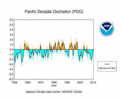
The Pacific Decadal Oscillation (PDO) can have a major impact on El Nino and La Nina. A negative PDO can enhance La Nina and a positive PDO can enhance El Nino. However, the opposite occurs if these are flipped - a positive PDO can greatly reduce the impacts of La Nina.
(NEGATIVE PDO)
Generally, we have been in a negative phase for the past few years, though last winter PDO was positive. This might have reduced the impact of last winter's moderate La Nina. Here is a month-by-month table of PDO for the past hundred years:

http://jisao.washington.edu/pdo/PDO.latest


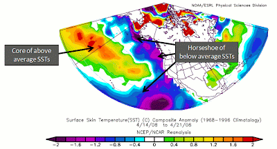
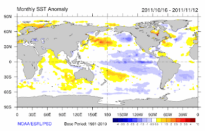
Cold waters prevail over the Gulf of Alaska and farther south off the coast of Mexico, so it looks like this winter will feature a slightly negative PDO, which could possibly enhance the weak La Nina. However, there has been no evidence of this occurring within the current weather pattern...yet.

(SEA SURFACE TEMPERATURE ANOMALIES FOR THE PAST MONTH)

24 Hour Rain Totals

(SAN DIEGO COUNTY)
(CALIFORNIA)

Winter Outlook Part 3 - La Nina

La Nina continues to strengthen as we head into winter. You can spot the cold waters off the South American west coast along the Equator. This La Nina is not nearly as strong as last year at this time.

(SEA SURFACE TEMPERATURE ANOMALIES IN OCTOBER)

The cold water extends well below the surface (200+ meters), so we will probably see some strengthening over the next couple months. Most computer forecasts also show this trend.

(TEMPERATURE ANOMALY BELOW THE SURFACE ALONG THE EQUATOR)

So what typically happens in a La Nina winter? As I stated in Part 1 of my outlook, there really isn't "normal" weather. We can calculate an average of all La Nina winters, so that you can get a general idea, but  I want to emphasize that each winter is unique.

You can see on the map below that La Nina will bring above average temps in parts of the Midwest and the Deep South. Below average temps prevail in the Northern Plains and Pacific Northwest. Unfortunately this map uses the 1971-2000 averages instead of the 1981-2010 averages.

(TEMPERATURE ANOMALY DURING  LA NINA)

Look at last winter's temperatures. They barely match the map above. It was cold across the entire eastern half of the United States. However, cold weather in the Northern Plains verified.

(TEMPERATURE ANOMALY FROM LAST WINTER)

Now let's look at the impact of La Nina on precipitation. La Nina winters on average will bring excessive rain to the Pacific Northwest and the Ohio River Valley. The Gulf Coast will remain extremely dry while the Midwest, Mid-Atlantic and Southwest U.S. will stay marginally dry.

(PRECIPITATION ANOMALY DURING  LA NINA)

The precipitation from last winter actually fit the averages fairly well. It was very dry in the Deep South with below average precip also in parts of the Midwest and Mid-Atlantic. However, Southern California and parts of Nevada received above average precip, which doesn't match the typical La Nina winter. In addition, Northern California stayed mysteriously dry.

(PRECIPITATION ANOMALY FROM LAST WINTER)

Now let's look at the Climate Prediction Center's forecast for this winter. You can see that their forecast is heavily influenced by La Nina conditions. They are going for heavy precipitation in the Pacific Northwest, Northern Plains and Ohio River Valley.

(CPC PRECIPITATION FORECAST FOR THIS WINTER)

CPC is forecasting a warmer than average winter in Texas and southern parts of the Midwest. They are expecting extremely cold conditions in the Northern Plains with slightly cooler than average temps along the entire West Coast.

(CPC TEMPERATURE FORECAST FOR THIS WINTER)

Although I agree with some parts of this forecast, I feel that they are taking the easy way out. It seems that they are just taking the average La Nina year and applying it to their forecast.

This year could easily end up being a "La Neutral" or a "La Nada" for a lot of people this winter. In other words, there are other factors that will impact this winter's weather and I will address them in my next update.

FORECAST

HOURLY TEMPERATURE FORECAST

COAST INLAND

BLOG ARCHIVE