ADVERTISEMENT

Irene - Forecast Verification

Although my track for Irene was correct, the storm's impact was more severe and farther west than I expected. I thought that the harshest part of the storm would remain within 50 miles of the eye. This was not the case. Irene had weakened a lot quicker than I expected, so it expanded. It's like a twirling figure skater who slows her spin by opening up her arms. This similar expansion allowed the heavy rains and powerful winds to extend nearly 80 miles from the center of the storm.

So let's recap my forecast made last Friday afternoon:

My forecast for Richmond remains the same. I think the city will see 1 to 3" of rain west to east. Some areas on the far eastern and southeastern edge could easily pick up over 4". I want to again emphasize that this will not be a continuous rain. Bands will bring occasional downpours.Winds will remain sustained 25 to 35 mph with gusts up to 45 mph at the peak of the storm Saturday night.

Norfolk, Virginia Beach and the Eastern Shore will see hurricane-force winds (70 to 90 mph) and rain totals from 6 to 10". If you live in between Richmond and these areas, you can pretty much take an average between the two.

A tornado watch will be issued Saturday evening and night for eastern VA as Irene interacts with the land. A brief weak tornado will be possible during this time. 

Here are some rain totals from the National Weather Service from west to east:
  • 2.2" Powhatan
  • 5.4" Richmond International
  • 8.2" Williamsburg
  • 11.0" Suffolk
  • 8.7" Norfolk
I was off by an inch or two around central Virginia, however, generally speaking the rain totals fit the forecast. In addition, there were two reports of tornadoes in eastern VA (Sand Bridge and Eastern Shore). So that part of the forecast also verified.


Winds were a different story. My forecast for southeast Virginia was generally acceptable but was terrible for central Virginia. Here are the hourly reports from Richmond International during the brunt of the storm.


Sustained winds ranged from 25 to 40 mph with gusts 50 to 60 mph. In fact, the max gust from RIC was 71 mph. Williamsburg had the highest gust in Virginia with 76 mph (which fell within my forecast range). Along with rain-soaked ground, these winds pushed over several trees and caused hundreds of thousands of Virginia residents to lose power.


I should have changed the forecast on Friday evening. I saw that Irene had weakened and expanded. I should have looked at surface observations across North Carolina and adjusted my wind forecast accordingly.


I am saddened to hear about the injuries and fatalities from this storm. While some of them could have been prevented (for instance the surfer), it make me sick thinking about that poor kid who died. I am a forecaster who prides himself in avoiding hype. I feel that people deserve the facts without having to be stirred up into a panic. However, downplaying this storm was like playing with fire and I got burned. On the flip side, just imagine if this storm had maintained its' strength and took the path of Isabel...the damage would have been devastating. We dodged a bullet in that regard.

Irene Update - Friday Evening

This will be my last update until after the storm. I'm leaving the forecast the same, so you can scroll down to see the details.

Looking at the satellite image of Irene, you can still see an area of strong convection (thunderstorms) near the center. You can also notice how Irene is starting to develop heavy precipitation along its' northern half. This is a sign that the storm is becoming an extra tropical system...in other words, it's weakening.


Nonetheless, Irene should remain a strong Category 1 hurricane as the eye passes just east of Virginia Beach and the Eastern Shore tomorrow afternoon and evening.

Here is a map of the forecast winds tomorrow evening around 7 PM. Notice how the winds are stronger along the right side of the storm. This is typical of every tropical system as forward momentum enhances wind speed (less friction over water helps also). This is why I downplayed this storm. Yes, Irene will cause a lot of damage. However, the violent right side of this system never really made landfall during peak intensity. Most historical hurricanes have the right front quadrant make landfall.


The next map shows the forecast rainfall at around 7 PM Saturday. Notice how the heaviest rain remains near the core of the storm. For this reason, the eastern third of Virginia will receive most of the rainfall.


The greatest danger from Irene will be flooding rains and the potential for isolated weak tornadoes Saturday afternoon and evening. Most of the rain will subside Sunday morning with winds gradually decreasing by midday.

Irene Update - Friday Afternoon

Irene will briefly maintain its' Category 2 status as it passes the Outer Banks, then it will gradually weaken as it moves north. In fact, it will probably be a strong Category 1 as the eye passes *just* east of Virginia Beach.


It is again important to note that the strongest winds and heaviest rains will reside within 50 miles of the eye of the storm. Winds and rain totals will drop off dramatically as you move farther west. That is why this is a tricky forecast...a 10 mile shift to the west could mean a lot. Here are the forecast images for Saturday evening and Saturday night. Notice how the heaviest rain stays generally in the eastern half of VA.


My forecast for Richmond remains the same. I think the city will see 1 to 3" of rain west to east. Some areas on the far eastern and southeastern edge could easily pick up over 4". I want to again emphasize that this will not be a continuous rain. Bands will bring occasional downpours.Winds will remain sustained 25 to 35 mph with gusts up to 45 mph at the peak of the storm Saturday night.

Norfolk, Virginia Beach and the Eastern Shore will see hurricane-force winds (70 to 90 mph) and rain totals from 6 to 10". If you live in between Richmond and these areas, you can pretty much take an average between the two.

A tornado watch will be issued Saturday evening and night for eastern VA as Irene interacts with the land. A brief weak tornado will be possible during this time. 

Although Irene will bring powerful winds and storm surge to the coast, ultimately speaking, I think it will be remembered for its' flooding rains. I still think New England will see some bad flooding (too much concrete). However, Irene is nothing like Isabel, especially for central VA.

Irene Update - Thursday Evening

The center of Irene will pass over the Outer Banks midday Saturday as a Category 3 hurricane. The eye will then pass over or *just* off the coast of Virginia Beach Saturday night as a Category 2 hurricane. Irene will then push fairly quickly up the coast Sunday afternoon.


If you are unfamiliar with the Saffir Simpson scale (Category 2 vs 3) you can visit the NHC website to see what to expect. There is no doubt that it will be bad in eastern North Carolina and Virginia.

http://www.nhc.noaa.gov/sshws.shtml

Here are the forecasted rain totals. I think Irene will move a little farther west than this computer forecast, but I think it paints a clear picture: rain totals will increase dramatically closer to the coast.


Norfolk, Virginia Beach and Eastern Shore could easily exceed 10". Northern Neck and Williamsburg could get 4 to 8". I'm still going 1 to 3" for Richmond. The rain will not be continuous for Richmond, but bands will bring periods of heavy rain. Here are a couple snap shots of the WSI RPM model for Saturday evening and night. I think the track will be slightly farther west, but I posted these images because it also shows how heavy rains stay near the center of a hurricane.


I should also mention that there will be a tornado watch issued Saturday night as the eye passes. Areas along and east of I-95 (Richmond included) should be aware of isolated weak tornadoes. This always happens with hurricanes because of strong wind shear.

Speaking of winds...

Just like rain, the strongest winds reside near the center of a hurricane. Look at the forecast below:


Again, I'm expecting a path a little farther west than this computer forecast. However, look how dramatically winds drop off from the center. Hurricane-force winds could extend all the way to Williamsburg, but will quickly drop off near Richmond. I'm going to stay with my original forecast for Richmond: 25 to 35 mph sustained winds with gusts up to maybe 45.

There is no need to panic if you live in Richmond. Probably the greatest severe weather threat will be the possibility of isolated tornadoes Saturday night. A couple trees might topple over, otherwise, if you just use your common sense, you will be fine! 

Quick Update - Thursday Morning

As a hurricane approaches, it is perfectly normal to see the path wobble a little. Last night and this morning we have seen a slight wobble westward. This won't have a dramatic affect on Richmond's forecast (sustained winds 25 to 35 with gusts up to 40 mph and 1 to 3" rain), but will make things much worse along the coastline if this path holds true. Remember, hurricanes do most of their damage from storm surge and flooding rains which are located near the center.

Forecast for the eye of the storm:

Right now, it looks like a Category 3 over the Outer Banks on Saturday evening. Then it will weaken to a strong Category 2 along the coast of VA Beach and Eastern Shore on Sunday morning. Irene then moves up into New England Sunday evening and night.

Note:

Bands will extend north of the storm, so rain will arrive earlier than the timeline posted above.


Irene Update - Wednesday Evening

Probably the biggest change with the latest data is the speed of Irene. Things have slowed down by about 12 hours. In addition, the operational ECMWF has shown a dramatic shift to the west with the eye over VA Beach Sunday morning, but when you look at the ECMWF ensemble mean (51 forecasts from the Euro averaged together) the track is back east off the coast. My bets are on it staying off the VA coast...for now.


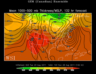
Let's look at the data. First we'll start with Saturday evening. Models generally agree on having Irene near the Outer Banks, though ECMWF is a little quicker and farther north. I do want to mention that the GEM has been terrible this entire event, but is finally coming together.


Now onto Sunday morning: all three models basically have Irene *just* off the coast of VA. Again, operational ECMWF has it 50 miles to the west. But I'm not buying that track...yet. Richmond is far from the center of Irene, so the impacts will not be as great. You can expect sustained winds of 25 to 35 with gusts up to 40 mph. Because Richmond is away from the center, the rain will not be continuous. Instead, rain bands will bring occasional downpours that will amount to 1 to 3". Rain totals will be significantly higher towards the coast, where isolated areas will pick up over 10" of rain. 


Last images are the forecast for Sunday evening. GFS pummels New England at this time. ECMWF and GEM are not as aggressive, but still have Irene as an impressive storm. I still contend that New England will get the most damage from this storm. Hurricanes have historically caused most of their damage from storm surge and flooding rains. New England will see a prolonged period of heavy rain that could amount to over 15" in less than a day!


Irene Update - Tuesday Evening

This will not be another Isabel for Richmond. In fact, the impacts on the Richmond area will be minimal with gusty winds 25 to 35 mph and isolated downpours. Virginia Beach will get hit hard, but will not see the brunt of the storm. I still think the hardest hit areas will be in New England (Philly, New York and Boston). These areas will see a prolonged period of heavy rain which will cause widespread flooding and damage.


Let's look at the data. Again, I will post the computer forecasts (ECMWF, GFS, GEM ensembles) for Friday evening and then Sunday morning. This will give you perspective on where the models are trending.

Friday evening:


Now Sunday morning:


The data continues to accelerate Irene. The intensity is about the same and the track is only slightly eastward. Historically speaking, tropical systems that have greatly affected Richmond in the past (Isabel, Gaston) did not take this path. Irene is moving fairly quickly and along the coast, so the brunt of the storm will miss central VA.

I don't want to give Richmond the "all clear" (data can sometimes change), but if I still lived there, I wouldn't be worried at all. Impacts along the Virginia coast will be greater with 70 mph wind gusts and rain totals as high as 9 inches (I'd be moderately worried). Farther north into New England, rain totals could easily exceed 15 inches in some isolated areas (I'd be worried).

My Thoughts On Irene - Monday Evening

I know I'm late in the game (I've been busy working two jobs), but I figured I'd give my two cents about Irene. People along the North Carolina and Virginia coasts should definitely keep a careful eye to the forecasts in the coming days. However, whenever a hurricane threatens the U.S. mainland, I'm always surprised about the amount of hoopla leading up to the storm. You have doomsday meteorologists and armchair forecasters screaming for attention and trying to scare people as much as possible.

I don't want to downplay this storm too much, though I don't think this storm will have as big of an impact as some forecasts portend. Let's look at the data. I'm going to post the ensemble forecasts of GFS, ECMWF and GEM. The first is from last night's data and the second is from this evening's data. Here are the forecasts for Friday evening:


Now here are the forecasts for Sunday morning:


The data this evening compared to yesterday evening shows a stronger Irene moving faster. In addition, the track has shifted slightly eastward. If these forecasts were to hold true, then Irene would be worse than hurricane Earl last year, but not nearly as bad as Isabel in 2003.

No area would get a direct hit from this storm (the right front quadrant), though North Carolina will be close. This means that the worse storm surge will stay out to sea. Also, there are no signs of this storm slowing down or stalling, which will decrease rain totals.

Lastly, this track would be different than Isabel, which hit the North Carolina coast at almost a 90 degree angle. Isabel also tracked straight into Virginia. Irene doesn't look like it will take this path. Instead, it looks like it will hug the coast, or possibly *just* off the coast. Here is the track of Isabel for reference:


Again, I want to emphasize that I haven't been watching the data too carefully. If you live along the South Carolina, North Carolina or Virginia coasts, you need to watch for the latest info from local meteorologists. However, you should be skeptical of any doomsday forecasts...for now...

Hopefully I will be able to have another update tomorrow.

FORECAST

HOURLY TEMPERATURE FORECAST

COAST INLAND

BLOG ARCHIVE